 March started on a dry note, paving way for hot weather conditions throughout the first half the month. Maximum temperatures across most of the country settled on the higher side, in fact, slightly above the normal average.
Relief was seen with the commencement of third week, as fairly widespread rains were recorded over several parts of the country. While northern parts saw rains on account of Western Disturbance and its induced cyclonic circulation, southern and central parts recorded rains due to depression that travelled from Bay of Bengal to Arabian Sea and a north-south trough running right from Central India to South India.
[yuzo_related]
With this, there was a drop in maximum temperatures and after long, mercury settled near normal mean over several parts of the country.
However, rains have bid adieu to the country now. As we enter into the fourth week of March, temperatures are likely to witness steep rise. According to weathermen, no significant weather system is likely to form over the country, thus, rains would not make a comeback anytime soon.
The only parts that could see some activities would be northeastern states or some isolated pockets of extreme South India. Rest parts of the country would now brace mainly for dry weather conditions.
In absence of any weather activity, temperatures would now start increasing. Meteorologists are predicting that initial days of the week would see hot weather conditions. The situation would become worse during the other half as rising mercury would amount to heatwave like conditions.
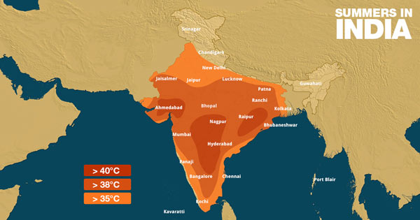
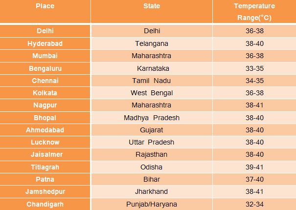
The worst affected areas would be Gujarat, Maharashtra, Telanagana, Andhra Pradesh and Odisha. Mercury is all set to reach 40-degree mark at most of the places including Delhi-NCR.
Let us have a look at the temperature profile across the major of the country next week:

Image Credit: NDTV
Any information taken from here should be credited to skymetweather.com


