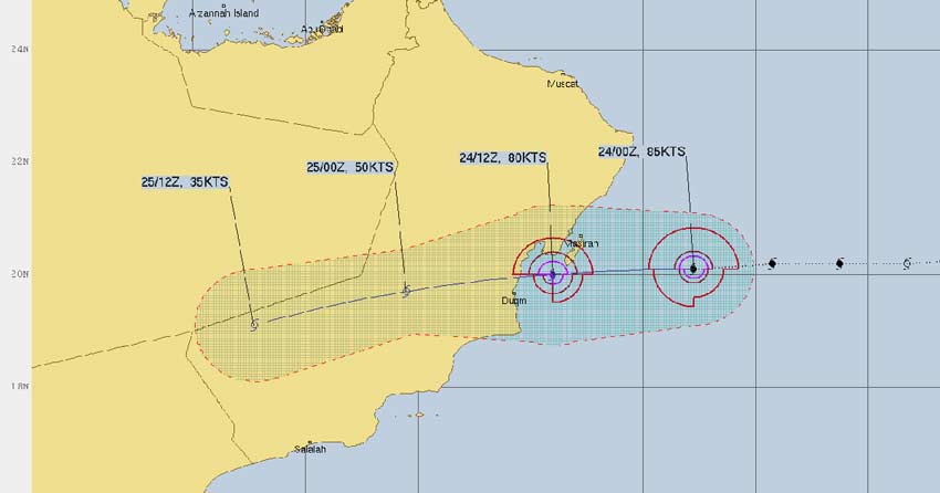
Cyclone Hikaa which formed yesterday has surprised us all. Hikaa has defied the model outputs which expected the storm to not intensify and were expecting the storm to remain a tropical Cyclone only.
Yesterday afternoon itself, Hikaa intensified into a Severe Cyclonic Storm. In fact, the storm underwent into another intensification today becoming a Very Severe Cyclonic Storm today, equivalent to Cat 2 Hurricane.
At present, Hikka is centered at 20.1°N, 60.9°E which is about 220 km east southeast of Masirah, Oman and 350 east northeast of Duqm.
The storm will continue to move in a west southwest direction because an Anti Cyclone is situated north of Arabian Sea and adjoining Arabian Peninsula which is a regular feature during this time of the year. That anti Cyclone is restricting its movement over the west northwestward side and pushing the storm southward.
Hikaa is expected to make landfall by tonight and is moving at a speed of 20 kmph with an oblong eye. The system is in favorable wind shear and high sea surface temperatures which will help the storm sustain it's strength until before the landfall.
However, during the time of landfall, Hikaa will slightly weaken, becoming a Tropical Cyclone. It will then move in a west Northwest direction, parallel to the Oman coast and go deep inside the country as a Tropical Cyclone.
The Cyclone will result in heavy rains, strong winds and even flash flooding in parts of Oman. After landfall, within 24 hours, Hikaa will move to the trijunction of Yemen, Oman and Saudi Arabia, giving rains over the other two nations as well.
Image Credit: JTWC
Please Note: Any information picked from here should be attributed to skymetweather.com


