Heavy rains to hit parts of Uttarakhand, Dehradun, Haridwar and Nainital, alert extended

July 9, 2019 12:39 PM|

Torrential Rains to lash Uttarakhand

The month of June was not a good one for Uttarakhand in terms of rainfall. However, from the past few days, intermittent rain and thundershowers are being witnessed in Uttarakhand with few moderate to heavy spells. In the past 24 hours, Pantnagar has recorded 36 mm of rain with 39 mm being observed in Mukteshwar.

From July 1 till date, Uttarakhand has recorded 133.2 mm of rains against the normal of 264.3 mm. According to our meteorologists, rainfall activity is going to increase gradually in Uttarakhand in the next 48 hours. A Trough is currently running from Punjab up to Northeast India across Haryana and Uttar Pradesh, which will Shif towards the foothills and increase activity in the region.

The shift in the movement of the Trough line will act as a catalyst and would give rains over the state until July 15 or July 16.

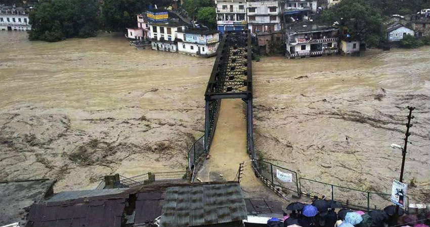
The southern districts of the state will be mainly affected with heavy to very heavy rains. We would like to extend caution for the residents ofDehradun, Haridwar, Tehri, Almora, Nainital, Udhamsingh Nagar, and Champawat against mudslides, landslides and cloud burst.

On the contrary, rain in Uttarkashi, Gangotri, Badrinath and Chamoli will be subdued with only a few good spells in pockets.

Weather Alert For Uttarakhand:

Moderate to heavy rain, thundershower and lightning strike would hit Almora, Bageshwar, Chamoli, Champawat, Dehradun, Garhwal, Hardwar, Nainital, Pithoragarh, Rudraprayag, Tehri Garhwal, Udham Singh Nagar, and Uttarkashi during the next 24 hours.

Image Credit: The Atlantic

Please Note: Any information picked from here must be attributed to skymetweather.com

Similar Articles

thumbnail image
March 20, Today Marks The Spring Equinox: Day-Night Duration Nearly Equal

The official transition from winter to spring, known as the SPRING EQUINOX, occurs today! It’s time when the Sun crosses the celestial equator precisely at 2:31 PM, delivering warmer, longer days to the Northern HemiSphere. As autumn arrives, the South enjoys colder evenings.

posted on:
thumbnail image
आज सूर्य करेगा भूमध्य रेखा पार, बसंत ऋतु की शुरुआत, दिन-रात की अवधि लगभग बराबर

आज, 20 मार्च 2025, बसंत विषुव (Spring Equinox 2025) का दिन है। सूर्य भूमध्य रेखा को पार करेगा, दिन बड़े और गर्म होंगे। उत्तर गोलार्ध में बसंत ऋतु की शुरुआत होगी, दक्षिण गोलार्ध में शरद ऋतु का आगमन होगा। वहीं, सितंबर में यह खगोलीय घटना फिर से होगी।

posted on:
thumbnail image
गर्मी का दायरा बढ़ा! ओडिशा, महाराष्ट्र, तेलंगाना और रायलसीमा में 40°C के पार तापमान, राहत की उम्मीद

देश में समय से पहले गर्मी असर बढ़ रहा है। ओडिशा, महाराष्ट्र, तेलंगाना, आंध्र प्रदेश में अभी तापमान से 40°C से ऊपर पहुंच गया है, जिस कारण इन राज्यों में भीषण गर्मी हो रही है। फरवरी 2025, पिछले 125 वर्षों में सबसे गर्म महीना रहा है। कई जगहों पर सामान्य से 6.4°C तक ज्यादा तापमान रिकॉर्ड हुआ है।

posted on:
thumbnail image
दिल्ली में बढ़ेगी गर्मी! शुष्क और तपता रहेगा वीकेंड, बारिश की संभावना हुई कम

दिल्ली में गर्मी बढ़ रही है, पिछले 3 दिनों में तापमान 4°C बढ़ा है। आज अधिकतम 34-35°C, न्यूनतम 17°C तक रह सकता है। मार्च अब तक लगभग शुष्क बना हुआ है, सिर्फ 2mm बारिश दर्ज हुई है। 26-28 मार्च को तापमान 40°C के करीब पहुंचने की संभावना है। वहीं,पश्चिमी विक्षोभ से मैदानी इलाकों में बारिश की संभावना नहीं है।

posted on: