Widespread rain and thundershowers have returned to the northwestern plains during the last 24 hours. These unseasonal rains can be attributed to an active Western Disturbance over the Western Himalayas and its induced cyclonic circulation over Northwest Rajasthan and adjoining parts of Punjab and Haryana.
Moreover, a trough is also seen extending from the above cyclonic circulation up to North Madhya Pradesh across Delhi and its nearby regions.
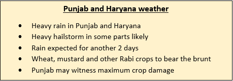
Now due to the combined effect of all these weather systems, few intense spells of rain and thundershowers along with isolated very heavy spells are likely over parts of Punjab. Several parts of Punjab and Haryana have already been reporting rain and thundershowers of varying intensity.
In Haryana, we expect scattered rain and thundershower activity to continue over most parts. However, intensity of rains over Haryana will be comparatively less than the rains over Punjab. The possibility of intense hailstorm activity cannot be ruled out over both these states.

By tomorrow i.e. February 15, as the above-mentioned weather systems will start moving away eastwards, rain intensity over Punjab and Haryana will reduce significantly. But still on and off rains will continue over the eastern parts of both these states.
From February 16 morning, weather conditions over the northwestern plains including the states of Punjab and Haryana will become dry. Temperatures will also once again start dropping and night temperatures will settle around 4˚C to 5˚C.
While these showers brought cheers for the residents, but farmers are on the receiving end. Rabi crop such as wheat, mustard and barley are in the standing stage and these spells of untimely rains accompanied with hailstorm and strong winds would lead to crop damage.
Thus, we can say that in agricultural perspective these rains and hailstorms are likely to cause huge losses to farmers of the region.
Image Credit: HTPunjab
Please Note: Any information picked from here must be attributed to skymetweather.com


