Update on December 6, 2017 6:50 AM: Cyclone Ockhi has weakened into a well marked low-pressure
As anticipated Cyclone Ockhi failed to give heavy to extremely heavy rains over Gujarat as the cyclone has dissipated before reaching Gujarat coast. The reason for its rapid weakening can be attributed to strong vertical wind shear in the order of 30 to 45 knots and moreover, it traveled over cooler sea surface temperatures which further aided in its weakening.
Dry winds from the west were also entering the system. Now, this weather system persists as a low over coastal areas of Gujarat. We do not expect moderate or heavy rains over Gujarat now but light rains may continue in some parts till today.
The weather is likely to clear up completely and the day will become sunny by December 7. Hence there is no threat in terms of strong winds or rain. The effect of Cyclone Ockhi was seen right from north coastal Karnataka to southwest Uttar Pradesh.
In the last 24 hours, rains were heavy over North Coastal Maharashtra and South Coastal Gujarat and light to moderate over Konkan and Goa, scattered light rains over observed over Gujarat region, southeast Rajasthan, parts of West Madhya Pradesh and Southwest Uttar Pradesh.
In the last 24 hours until 08.30 am Santa Cruz observatory of Mumbai has recorded rain to the tune of 54 mm, Colaba 82 mm, Dahanu 105 mm, Harnai 21 mm, Alibaug 7 mm, Thane 20 mm Vengurla 13 mm and Goa 6 mm rains. In the last 24 hours until 08.30 am Valsad has recorded rain to the tune of 49 mm, Surat 12 mm, and Ahmedabad 10 mm rains.
Update on December 5, 2017 6:50 PM: Cyclone Ockhi weakens into deep depression, may or may not cross Gujarat coast
Cyclone Ockhi continues to weaken gradually and is now seen as a Deep Depression over east-central Arabian Sea. It is centered at Latitude 19°N and Longitude 71.3°E, around 260 km southsouthwest of Surat and 140 km west ofMumbai.
According to Skymet Weather, the deep depression would continue to move northnortheastwards. During this time, the system would weaken further and cross the Indian coast between South Gujarat and adjoining North Maharashtra nearSuratas a Depression by tonight.
[yuzo_related]
In fact, there is also a possibility of dissipation of the system over the sea before making the landfall as the system is now tracking in unfavorable weather conditions. According to weathermen, the system has entered into relatively cooler sea surface temperatures and high vertical wind shear and both the factors does not support the system.
Update on December 5, 2017 10:50 AM: Very severe Cyclone Ockhi degenerates into cyclone, rains in Mumbai, Surat
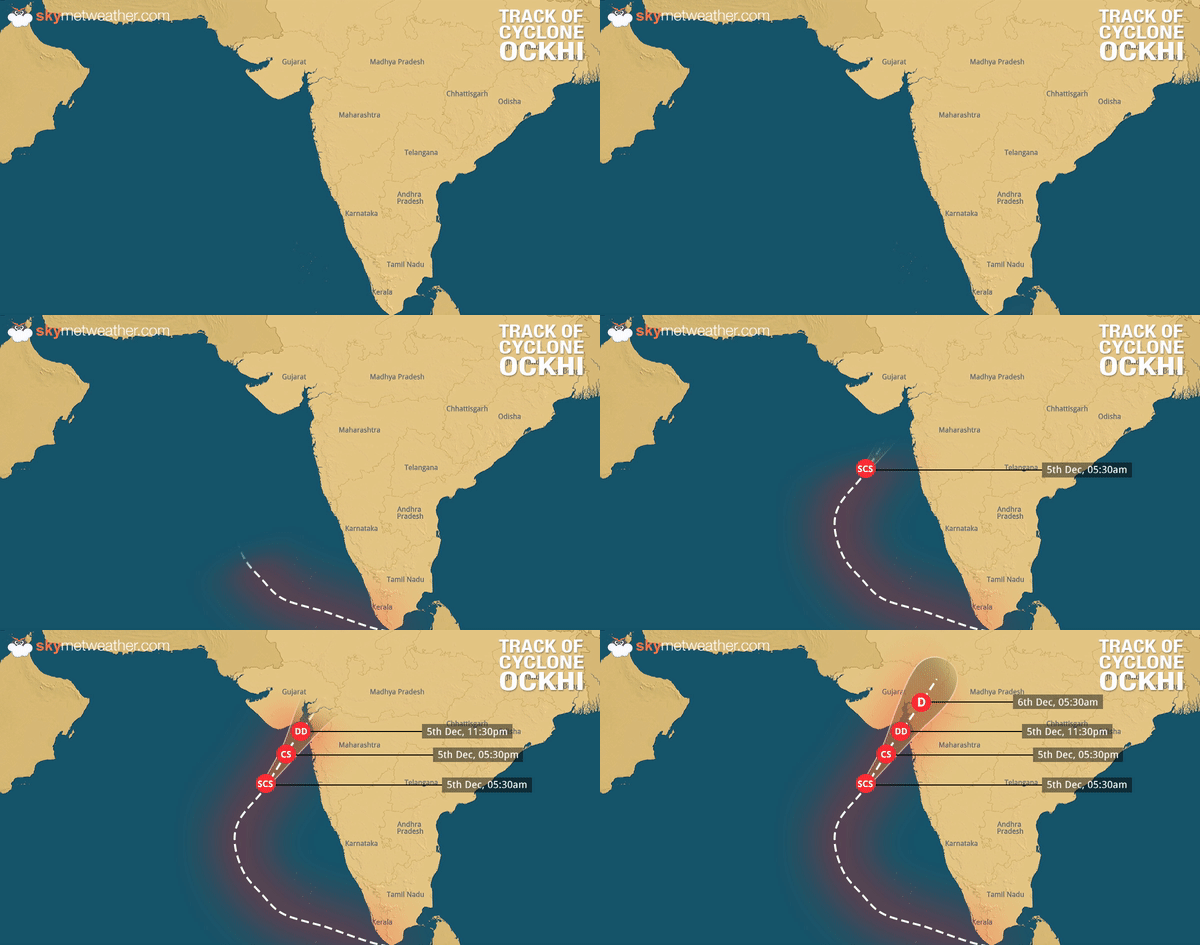
The very severe cyclonic storm Ockhi which was over east central Arabian Sea has re-curved north-northeastwards. Not only this, it has now become less marked and degenerated into a cyclonic storm. It is centered near Latitude 15.7°N and longitude 69.2°E, about 720 km south-southwest of Surat and 540 km southwest of the city of Mumbai.
The weather system will continue to move in a north-northeastward direction, weakening gradually and becoming a deep depression or depression by tonight when it crosses Gujarat coast.
Update on December 4, 2017 07:20 PM:Rains have begun over Mumbai, Pune, Thane, Surat, Bhavnagar.
Update on December 4, 2017 07:00 PM: According to Skymet Weather, Ockhi is seen over east-central Arabian Sea and is centered at Latitude 14.2°N and Longitude 69°E, about 590 km southwest of Mumbai and 770 km southsouthwest of Surat.
Weather models are indicating that system would most likely continue to move in northnortheast direction and weaken gradually. Ockhi is likely to cross the coast of South Gujarat and adjoining North Maharashtra near Surat as a deep depression or depression by the night of December 5.
In wake of this, light rains are likely over many parts of Mumbai tonight. Intensity of rains will increase by Tuesday morning, wherein Mumbai could see light to moderate showers.
Update on December 4, 2017 10:50 AM: Very severe Cyclone Ockhi to give rains over Mumbai, Gujarat now
Very severe Cyclone Ockhi is moving in a north northwest direction since last 12 hours. At present, the system is near Latitude 14.5°N and Longitude 16.5°E about 590 km NNW of Amini Divi, 690 km SSW of Mumbai and 870 km SSW of Surat.
The system will continue to move in NNW direction for another six to eight hours. Thereafter, the system is expected to recurve in a NNE direction towards Gujarat coast. As the cyclone will commence its journey into North Arabian Sea, it will encounter strong vertical wind sheer of 25 to 30 knots and sea surface temperatures will also be relatively cooler.
Dry winds from the west will also entrain the system. Due to these unfavourable conditions, we expect very severe cyclone Ockhi to start weakening rapidly. By the time it reaches Gujarat, it will not be able to maintain the cyclone status.
Thus, light rains will commence over North Konkan and Goa including Mumbai by tonight. By morning of December 5, many districts of Gujarat will also start receiving light rains with increased intensity gradually. Few moderate showers are expected. Sea conditions will become rough over North Maharashtra and Gujarat coast.
Wind speed may also increase and reach up to 30-40 kmph and gust up to 50 kmph. However, it will not be as devastating as it was in Kerala and Lakshadweep. People are advised not to venture out in the sea.
Updated on December 3, 2017 09:50 AM: Very severe cyclone Ockhi persists, to recurve towards Gujarat now
The Very Severe Cyclonic Storm Ockhi over Lakshadweep area and neighboring Southeast Arabian sea has further moved northwestwards with a speed of 14 kmph amid the last six hours.
[yuzo_related]
As of today, 05:30 hours IST, the system is over Southeast Arabian Sea near Latitude 11.1°N and Longitude 69.7°E, about 390 Km west-southwest of Amini Divi, 910 km south-southwest ofMumbaiand 1120 km south-southwest of Surat.
It will continue its track north northwestwards during the next 12 hours and afterward recurve northeastwards amid the subsequent 48 hours and weaken gradually.
Weathermen are of the view that heavy rain is likely at isolated places over North Lakshadweep Islands. These rains will be accompanied by squally winds reaching 50-60 kmph gusting to 70 kmph over and around the region.
Blustery winds of 40-50 kmph gusting to 60 kmph are also anticipated over and around South Lakshadweep Islands. Sea conditions are foreseen to be high over and around North Lakshadweep Islands. So, fishermen are advised not to venture into the Sea along and off Kerala, Goa and Karnataka Coast.
Updated on December 2, 2017 09:05 AM: Very severe Cyclone Ockhi to intensify, Lakshadweep to get very heavy rains
The very severe Cyclonic Storm Ockhi over Lakshadweep area and adjoining Southeast Arabian sea has moved west northwestwards with a speed of 12 kmph during the last 6 hours.
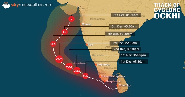
As of 0530 hours IST today, the system is centered over Lakshadweep area and adjoining Southeast Arabian Sea near Latitude 9.2°N and Longitude 72.8°E, about 100 km north northwest of Minicoy and 210 km south of Amini Divi.
This system is most expected to strengthen further during the next 24 hours and continue its track in west northwestwards across Lakshadweep Islands during the next 24 hours and then recurve northeastwards during the subsequent 48 hours.
In wake of this, heavy to very heavy rains are possible over isolated places of Lakshadweep. Isolated areas of Tamil Nadu and Kerala will also witness heavy rain activity.
Wind speed is likely to be 120 kmph over and around Lakshadweep Islands. Sea conditions will be rough around the region. So, fishermen are advised not to venture into sea along and off the coasts of Kerala and Karnataka and around Lakshadweep Islands.
Updated on December 1, 2017 06:45 PM: Ockhi intensifies into Very Severe Cyclonic Storm
The Severe Cyclonic Storm over Lakshadweep region and adjoining Southeast Arabian Sea continued to move westnorthwestwards with a speed of 15 kmph during the past 6 hours. The system has further intensified into a Very Severe Cyclonic Storm and is over Lakshadweep area and adjoining Southeast Arabian Sea near Latitude 9.1°N and Longitude 73.0°E, about 90 km north of Minicoy and 220 km south-southeast of Amini Divi.
The system is very likely to intensify further during the next 24 hours. It is anticipated to continue moving in west-northwestwards across Lakshadweep Islands during the next 24 hours and then move north-northeastwards during the subsequent 48 hours.
Updated on December 1, 2017 10:00 AM: Ockhi intensifies into severe cyclonic storm, Lakshadweep on high alert
As predicted, the cyclonic storm Ockhi over Southeast Arabian Sea has intensified into a severe cyclonic storm around 05:30 am on Friday. It has been moving in west-northwestwards with a speed of about 17 kmph. The system is centered at Latitude 8.8°N and Longitude 74°E, around 105 km north-northeast of Minicoy and 280 km southeast of Amini Divi.
According to Skymet Weather, Ockhi is very likely to continue moving west-northwestwards across Lakshadweep Islands during the next 24 hours. Have a look at the expected track of Cyclone Ockhi.
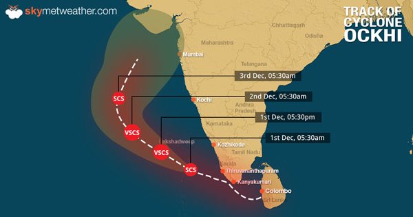
In fact, with more sea travel left, the system is very likely to get more marked during next 24 to 48 hours. “It will continue to move in warm sea surface temperatures of around 30°C and vertical wind shear is also low. It would continue to travel in northwest direction for next 48 hours. Thereafter, it is expected to re-curve towards north-northeast and would start weakening rapidly due to low sea surface temperatures,” Mahesh Palawat, Vice President- Meteorology, Skymet Weather.
In wake of this, Lakshadweep Islands have been put on high alert. Weathermen are predicting heavy to very heavy rainfall, with isolated extremely heavy falls over Lakshadweep area during next 24 hours. Thereafter in subsequent 24 hours, as the system moves away, rains may reduce a bit but isolated heavy to very heavy rains cannot be ruled out.
Meanwhile, in Kerala, rains and thundershowers of varying intensity may continue over most parts, with heavy rainfall at isolated places during next 24 hours.
Intensity of rains would now reduce over most parts of Tamil Nadu but moderate showers would continue. Chennai will also receive on and off showers on Friday but with reduced intensity.
Updated on November 30, 2017 7:30 PM: Cyclone Ockhi to form into severe cyclonic storm in 24 hrs
The Cyclonic Storm Ockhi over Comorin area and neighbourhood has moved westnorthwestwards during the last 06 hours and is now seen over South Kerala coast and adjoining areas. It has been moving in the speed of around 20 kmph.
Ockhi is presently centered at Latitude 7.9°N and Longitude 76.4°E, around 150 Km west-southwest of Kanyakumari, 160 km south-southwest of Thiruvananthapuram and 340 km east southeast of Minicoy.
The system would continue to move in westnorthwestwards towards Lakshadweep Islands. With long sea travel left, weather conditions will remain conducive for cyclone to intensify further into a Severe Cyclonic Storm during the next 24 hours.
Updated on November 30, 2017 02:30 PM: Cyclone Ockhi forms, severe cyclonic storm likely in 24 hrs
As predicted, the deep depression over Comorin area has intensified further into Cyclone Ockhi by the noon of Thursday. This is the maiden tropical storm of the season to develop in any of the Indian Sea.
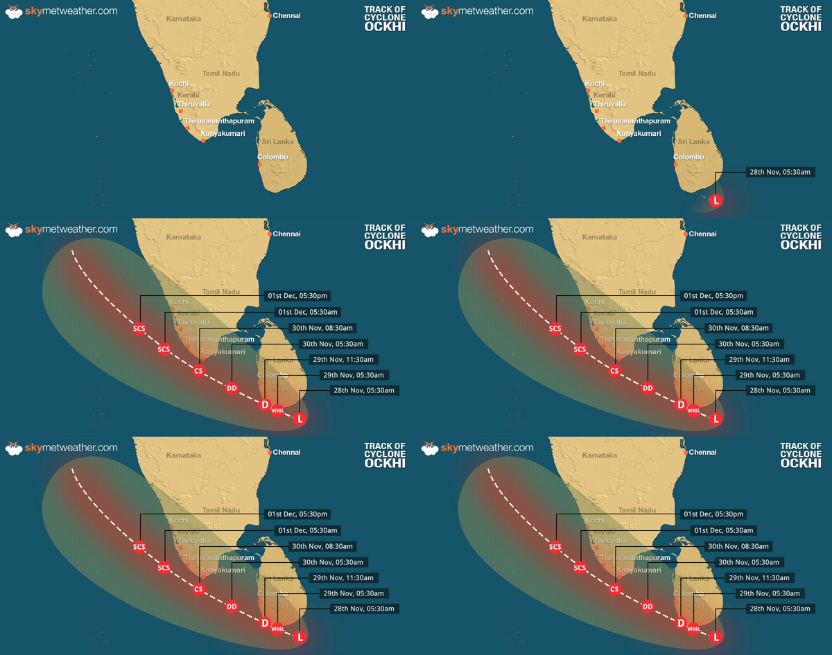
Moving at a speed of 38 kmph, the system is tracking westnorthwestwards. It is centered at Latitude 7.5°N and Longitude 77.5°E, around 55 km south of Kanyakumari, 120 km southwest of Thiruvananthapuram, 480 km eastsoutheast of Minicoy and 340 km westnorthwest of Galle in Sri Lanka.
According to Skymet Weather, the cyclone would continue to move westnorthwestwards towards Lakshadweep Islands. Weather conditions remains conducive for the further strengthening of the system into a severe cyclonic storm in the next 24 hours.
“At present, the system is traveling in warm waters as sea surface temperatures are very warm to the tune of 30°C. Besides this, vertical wind shear is also low. Both the factors will keep the conditions conducive for further intensification of the system into a severe cyclonic storm,” said Mahesh Palawat, VP-Meteorology, Skymet Weather.
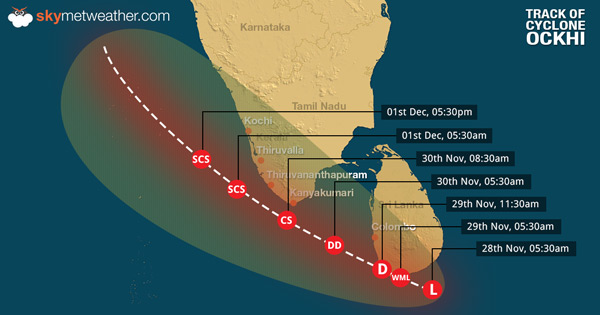
This system will trigger high velocity winds with the speed ranging from 65-75 kmph gusting to 85 kmph along and off South Kerala and South Tamil Nadu during the next 48 hours and 24 hours, respectively.
Meanwhile,Lakshadweepwould witness squally winds with the speed of 55-65 kmph gusting to 75 kmph during next 12 hours. Speed of winds is most likely to increase to 80-90 kmph gusting to 100 kmph from Thursday night as the system nears the island.
Heavy to very heavy rains are expected to lash southern parts of Kerala and Tamil Nadu. In fact, weathermen are predicting some torrential rains with damage potential over Alappuzha, Kottayam, Idukki, Kollam, Pathanathitta,Thiruvananthapuram,Kanyakumari, Tutukudi and Tirunelveli.
Heavy rains with squally wind are already being reported from these areas. With more rains in offing power outrage, snapping of communication lines, uprooting of trees cannot be ruled out.
Updated on November 30, 2017 11:30 AM: First cyclone of the season 'Ockhi' to form in Arabian Sea soon
The first tropical storm of the season is finally on its way. According to Skymet Weather, the depression over Sri Lanka further intensified into a Deep Depression in the wee hours of Thursday morning.
Moving westsouthwestwards, the system is seen over Comorin region and nearby areas and is presently centered at latitude 6.7°N and Longitude 78.3°E, around 170 Km southeast of Kanyakumari and 240 km westnorthwest of Galle in Sri Lanka.
Cloud configuration and atmospheric conditions are indicating towards the further strengthening of the deep depression into a cyclonic storm by Thursday evening. The cyclone would be named as ‘Ockhi’, which would be the first tropical storm of the season to develop in Arabian Sea.

According to weathermen, the weather system is presently travelling in favourable weather conditions into warm sea surface temperatures with abundant moisture. Weather models are predicting that chances of cyclonic storm intensifying into a severe cyclonic storm also cannot be ruled out, with long sea travel ahead.
Currently, potential cyclone is moving in west-northwest direction towards Southeast Arabian Sea. With this, intensity of rains will be extremely heavy over southern tip of peninsular region that would include Kerala and South Tamil Nadu.
Places likeKanyakumari,Cuddalore, Sriviakuntam, Tutticorrin, Rameshwaram, Ramanathapuram, Tondi, Nagercoil, Kovilpatti, Pamban, Thiruvananthapuram, Alappuzha, Kollam,Kochi, and Kottayam may see torrential rains during the next 24 hours.Chennaimay also see on and off moderate rain with few heavy spells on Thursday.
Sea will be rough to very rough off and along the coast of Kerala and South Tamil Nadu for another 48 hours. Fishermen and locals are advised not to venture out in the sea during the time.
After reaching Southeast Arabian Sea, cyclone is most likely to move in northwest direction towards west central Arabian Sea. With the system moving away, rains would reduce gradually over Tamil Nadu after 24 hours and over Kerala after 48 hours.
Any information taken from here should be credited to skymetweather.com


