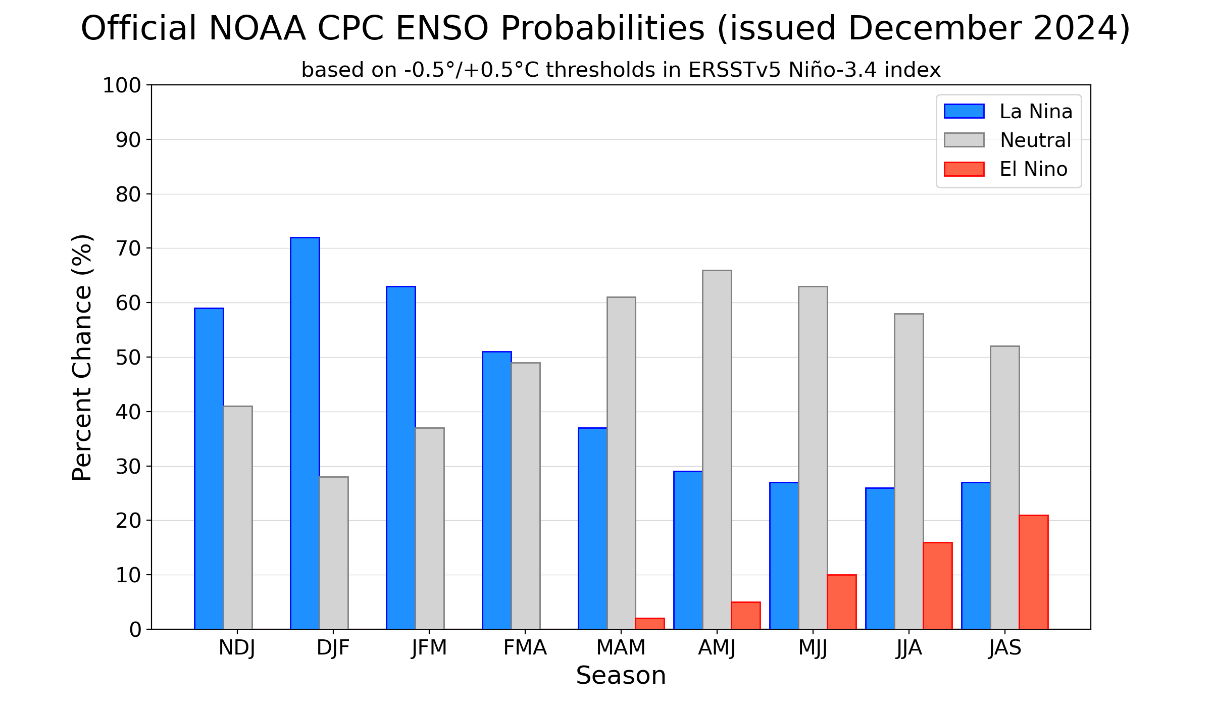
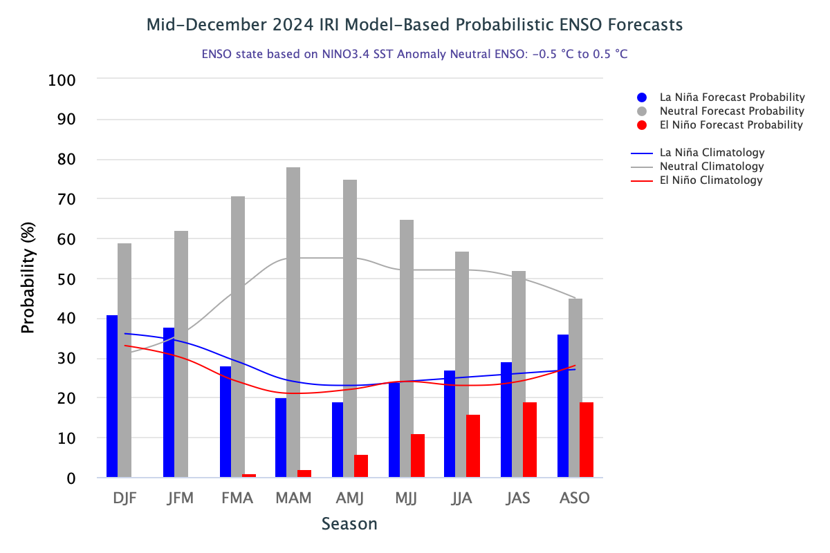
El Nino and La Nina, both, are known for creating chaotic climatic conditions over different parts of the globe. However, this statement is subject to the longevity of the event, coupled with the intensity. Typically, these events persist for 9-12 months and occasionally for up to 2 years. The impact of the El Nino/La Nina can be realized better when a full-fledged event materializes. Earlier, the shortest La Nina has been recorded for at least five quarters: ASO 1983 – DJF 1984 and OND 2005 – FMA 2006. The CPC ENSO Outlook predicts a preference for La Nina during the winters of 2025, followed by a return to ENSO-Neutral (61% chance in March-May 2025). This will be the shortest stint of La Nina on record. And, the shorter the event, the lesser is its impact on the climatic conditions. As against the predicted La Nina, the monsoon 2024 and post-monsoon 2024 have performed without its appearance and done reasonably well. The dichotomy between the CPC ENSO Outlook and objective IRI model-based ENSO Outlook has further complicated the forecast of winter and boreal spring of 2025.
ENSO: The oceanic and atmospheric conditions together decide the state of ENSO. An equal amount of weight is attached to both. Though, the ocean conditions are always more volatile than their counterpart, the atmospheric wing. Currently, the oceanic conditions across the tropical Pacific indicate an ENSO-Neutral state, while the atmosphere indicators exhibit characteristics reminiscent of La Nina. The reduced strength of trade winds during Nov 2024, has now energized and likely to sustain. These are the positives for likely La Nina, albeit weak and brief, in the month of Jan 2025.
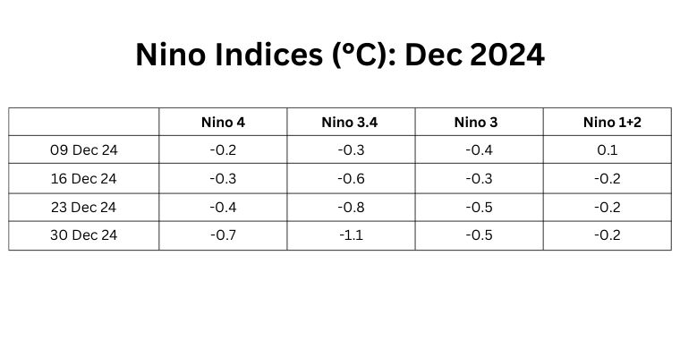
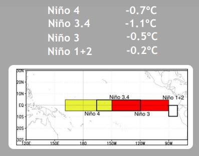
The Nino indices have reached the threshold mark of -0.5°C or less, except in the Nino 1+2 region. The ONI marker Nino 3.4 has shown a significant drop to double cross the threshold mark. The latest value of Nino 3.4 for the week ending 30 Dec 2024 was -1.1°C, the lowest since Nov 2022, when the triple dip La Nina was continuing. The average value of this index for Dec 2024 is -0.62°C, way above the threshold marker. Even October 2024 was fairly close to the threshold mark, at minus 0.4°C. Yes, November in between was a dampener which paused the progress of La Nina. The average value of ONI for the quarter ending OND is -0.4°C.
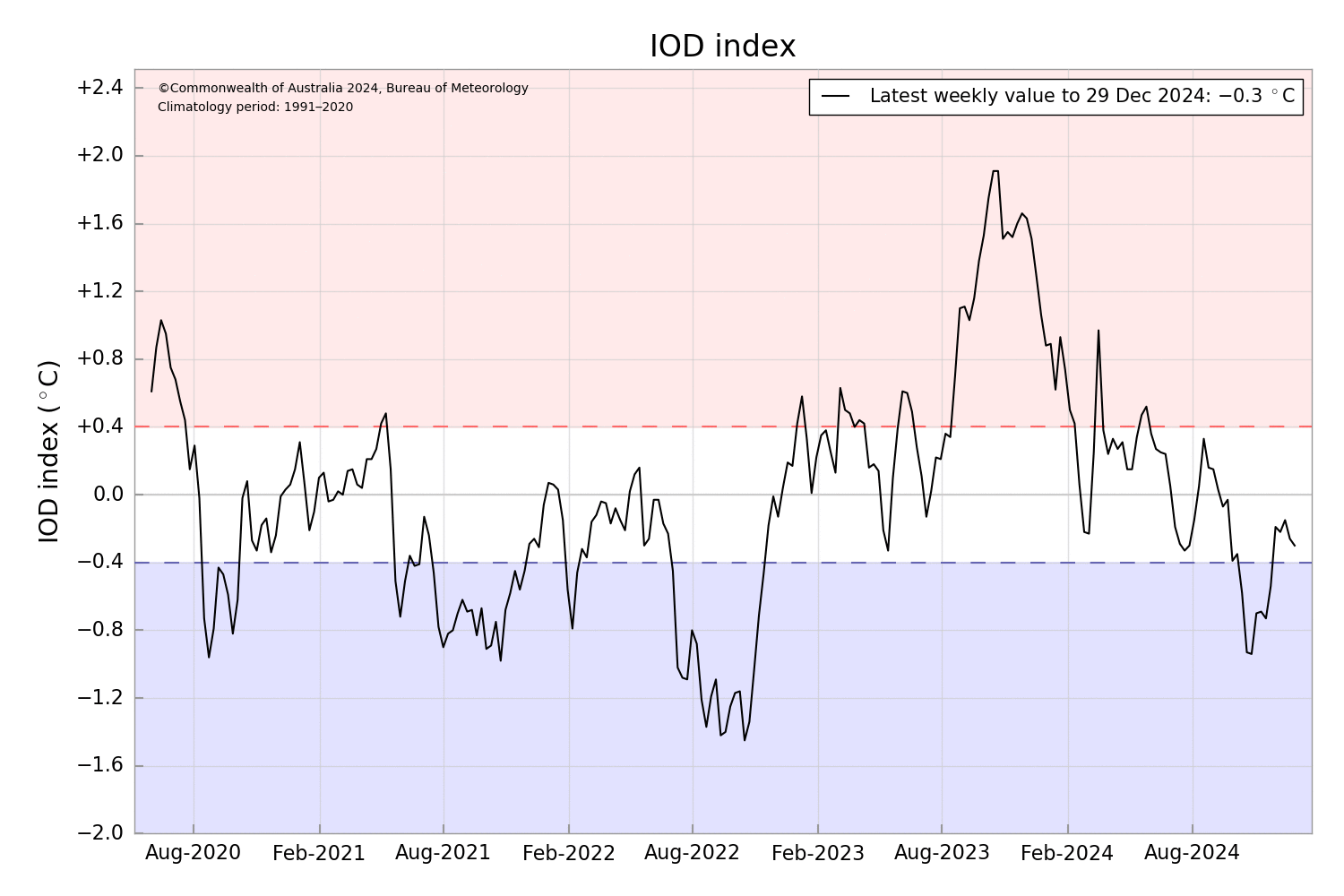
IOD: The Indian Ocean Dipole remains neutral. The latest value of the index for the week ending 29th Dec 2024 was -0.3°C. This is in line with typical IOD behaviour at this time of the year.
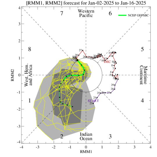
MJO: The Madden-Julian Oscillation will propagate eastward from the West Pacific and come close to the Indian Ocean by the middle of Jan 2025. It will gain amplitude while sailing over the Western Hemisphere and Africa region. Developing La Nina conditions over the Pacific, as well as negative IOD will interact with the MJO and the pulse may slow down or even stagnate for some time, before reaching the Indian Ocean in Phase 2. The chance of tropical cyclone development over the Indian seas is minimal. However, an active MJO returning to the Indian Ocean is expected to bring a renewed cyclone genesis potential in the Southern Indian Ocean around mid-Jan 2025.
La Nina is likely to make its appearance in the quarter Nov-Dec-Jan. How it influences the winter rains of India in Jan-Mar, is difficult to comment. The past history has no conclusive evidence of enhanced winter rains, except in a few cases. This means that exceptions not be ruled out but the chances look bleak.


