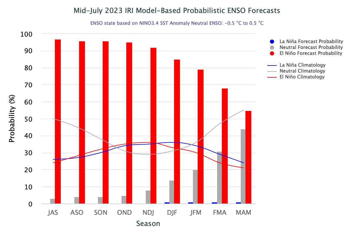
Tropical Pacific has become adequately warm. The atmospheric anomalies in the Pacific are becoming synonymous with moderate El Nino conditions. All the models indicate sea surface temperatures (SST’s) will remain above El Nino threshold until at least the end of the year.
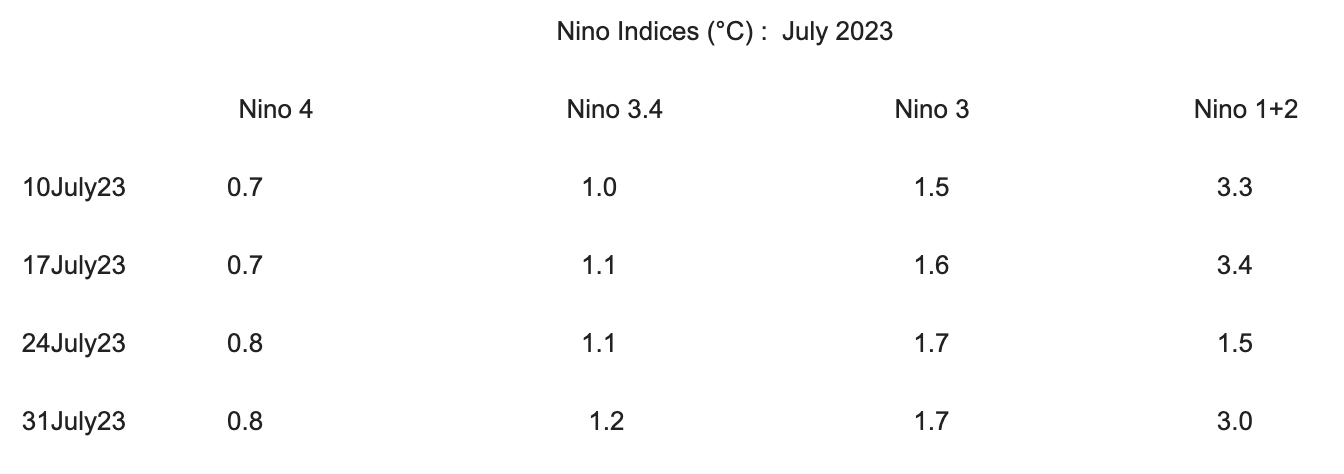
ENSO : Since March 2023, bigger and positive SST anomalies in the eastern Pacific Ocean have gradually expanded westward. Nino 1+2 has marginally dropped to measure departure of 3°C, whereas Nino 3.4, the principal indicator of Oceanic Nino Index (ONI), has registered minor rise of 0.1°C. The ONI has remained persistently above 1°C for the last 4 weeks.
For the 5 days normal ending 30 July 2023, sub-surface temperatures were also warmer than average across the upper levels of the equatorial Pacific (between the surface to around 150mtr depth) in the central and eastern Pacific. Weak cool anomalies were present between depths of 100-250mtr in the western and adjoining central Pacific. Trade winds for the 5 days, ending 30 July 2023 were close to average over most of the tropical Pacific. During El Nino, there is a sustained weakening, or even, reversal of trade winds across much of the tropical Pacific Ocean.
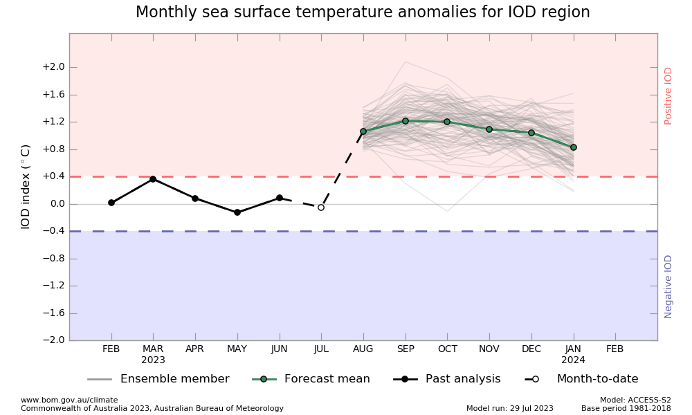
IOD: The Indian Ocean Dipole is currently neutral. The IOD index for the week ending 30 July, 2023 was +0.16°C. IOD remained negative and neutral for the last 7 successive weeks. The index fluctuated between 0.0°C and -0.31°C. The model survey indicates the likelihood of a +VE IOD event, maturing late in the monsoon season and autumn months. Earlier, during the issuance of the monsoon forecast, the models were indicating +VE IOD early in the season. But, that did not occur. At the same time, El Nino has been evolving faster than expected. Few models are now suggesting a transition to +VE IOD during this month. This needs close monitoring and critical observation. As compared to El Nino, models do not have adequate skills in accurately predicting IOD. Also, the correlation between the Indian monsoon and IOD is not strong. A healthy +VE IOD is necessary to counter the ill effects of El Nino. Absence of such a scenario may leave worry for the rest of the monsoon season.
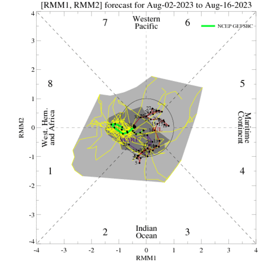
MJO: The Madden Julian Oscillation is the major fluctuation in the tropical weather on a weekly to monthly time scale. The MJO can be characterized as an eastward moving pulse of cloud and rainfall near the equator that typically recurs every 30-60 days. However, the signal of the MJO in the tropical atmosphere is not always present. Despite evolving El Nino conditions and negative neutral IOD, heavy monsoon bursts in the month of July over the Indian region are largely attributed to MJO. The MJO is currently weak but some models indicate strengthening in the Western Pacific region over the coming days. If true, the MJO may contribute to potential El Nino development by slowing down the trade winds.
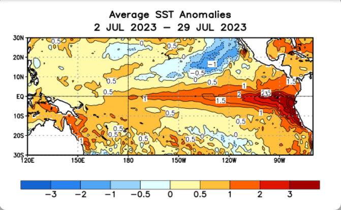
If the atmosphere responds quickly, strengthening of El Nino can speed up. Till last week, the atmosphere was lacking in response, as the Southern Oscillation Index, after turning negative in May 2023, slipped back to neutral in June & early July. Wind, cloud and broad scale pressure pattern was mostly aligned with neutral ENSO conditions. Southern Oscillation(SO) need to be necessarily in sync with El Nino for a firm coupled response. Together, they pose for most powerful fluctuation in the climate system, anywhere on earth.


