The cyclical variations of warming and cooling of the sea surface of eastern and central Pacific Ocean result mysterious El Nino and La Nina. These are the largest climatic fluctuations which have far reaching implications for global climate pattern and weather events. While the reasons for initiation and cessation of ENSO remain precarious but a latest study reveals compelling evidence that human induced climate change has become a dominant trigger of El Nino behaviour in recent decades. Human activities seem to have increasingly overlaid natural factors transforming the perspective of this historical climate variation.

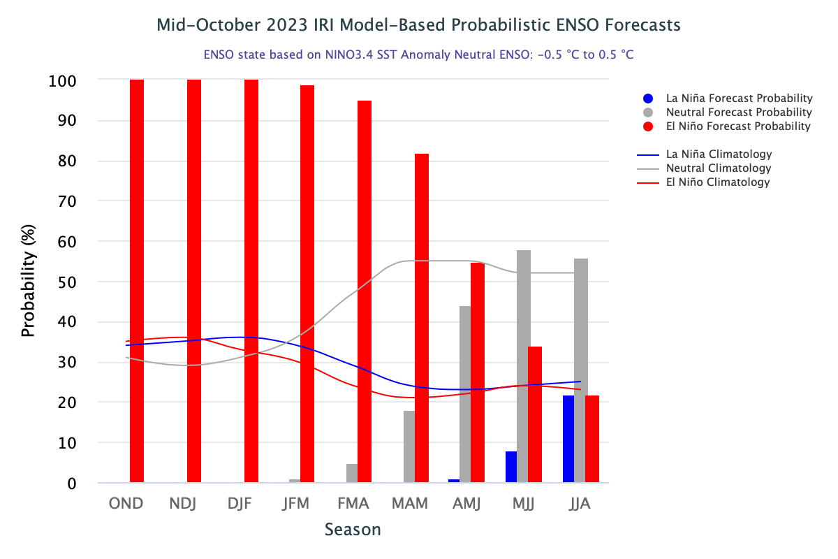
There is a broad consensus on emergence of a ‘strong’ El Nino event with a 75% - 85% chance through Nov – Jan, wherein, the Oceanic Nino Index (ONI) will exceed or retain an anomaly of +1.5°C. There is a 30% chance of an ‘historically strong’ event paralleling rival episodes of 1997-98 and 2015-16. Irrespective of gauge of the event, strong impacts are witnessed locally, attributable to both, moderate and strong El Nino.

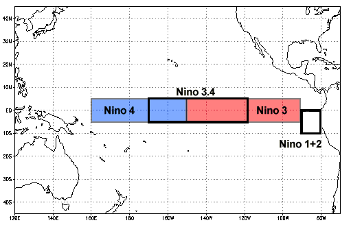
ENSO: As of the end October 2023, El Nino conditions in the central – eastern equatorial Pacific Ocean seem to have plateaued at the level of a moderate El Nino event. Nino 3.4, the principal indicator and firm representative of ONI remain narrowly confined between 1.5°C and 1.6°C, for the last 2 months. The eastern half of the Nino region is quite warmer than the central portion, akin to ‘Canonic El Nino’. A steady pattern has emerged since 28 August 2023.

Trade winds strength has been consistently weaker than average over most of the Equatorial Pacific Ocean. This is in consonance with further warming of the ocean keeping the Nino indices sufficiently above the threshold value, for extended periods.

IOD: Indian Ocean Dipole, sometimes referred to as the Indian Nino is similar to the El Nino, occurring in the relatively smaller area of the Indian Ocean between the Indonesian-Malaysian coastline in the east and the African coast near Somalia in the west. Both are consequential to ocean-atmosphere coupling. However, the longevity of IOD event is much smaller than the average duration of El Nino. Also, the occurrence of consecutive IOD, +VE or -VE, is rare.

There was a clear gradient between the western and eastern tropical Indian Ocean, that is synonymous with +VE IOD. The IOD index for the week ending 22nd October was +1.79°C, a little drop from the last week value of +1.92°C. The index has been maintaining unusually large value of 1.5°C or more for the last 4 consecutive weeks. Continuation of above threshold value for another 2 weeks will qualify formally as +VE IOD event 2023. This also means, that season 2024, in all probabilities, may witness either neutral or negative IOD.

MJO: The Madden Julian Oscillation is currently weak. There is fair amount of agreement on strengthening in the coming weeks. However, position of the pulse remain ambiguous. While some models suggest its amplification over Western Pacific, the others are inclined for development over the tropical American region. In any case, it remains far away from the area of interest over Indian Seas. No intense convection is expected over equatorial region of Andaman Sea, South Bay of Bengal and Lakshadweep region.
El Nino adverse effect has spilled over beyond southwest monsoon over the Indian Sub-Continent. Tropical cyclones over Bay of Bengal and Arabian Sea followed diverse tracks, sapping the landmass, resulting driest week between 19th- 25thOctober. Earth had its 4th warmest October on record, last year. Europe saw warmest October in 113 years. This year, chaotic climatic fluctuations like ‘super’ El Nino and ‘Great’ IOD may drive yet another feather, of October being the warmest ever on record. Hottest ever September, followed by searing October, may firmly set 2023 to be warmest year on record.


