Southwest Monsoonis nearing for the Indian subcontinent. The ongoing pre-monsoon season will soon be followed by Monsoon. Although Monsoon is still three months away, forecasts for Monsoon start storming in March onwards.
Even thefaintest appearance of El Ninostarts casting shadows upon Monsoon.
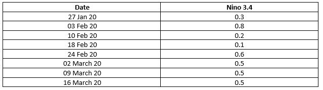
Looking at current stats, since mid-September 2019 onward, the Pacific Ocean has been sufficiently warmer than normal. Specifically, Nino 3.4 has been sufficiently warmer and the quarterly index for the last three successive events remains close to 0.5.
Current model projections are indicating neutral conditions during Monsoon months with a probability of more than 50%. In other words, in this Monsoon,El Ninois likely to remain neutral with a probability of 50%.

But how are these predictions made? What is the one main ingredient for all Monsoon forecasts? Here we dive in deeper into that-
Ocean’s heat potential has got a significant role in the performance of Monsoon in India. To find this heat potential, scientists measure ocean’s heat indices, and this is exactly where the forecasts lie. One of the top indices is El Nino. This is one of the indices that finds a strong correlation to Monsoon.
Another component that raises many eyebrows around Monsoon forecasts is the Oceanic Nino Index (ONI) which is based on Sea Surface Temperature (SST) departure from average in the Nino 3.4 region. This is the principle measure in monitoring, accessing andpredicting El Nino. ONI or Oceanic Nino Index can be defined as a 3 month running mean of SST departures in the 3.4 region.
To be qualified for the El Nino episode, this threshold must be exceeded for at least a period of 5 consecutive overlapping 3 seasons.
As matter of fact, India is a farming based economy where 60% of its cultivable lands depends on the Monsoon rains. Kharif is the main crop during Monsoon in India. Bad rains in Monsoon are a direct indicator for a bad crop yield.
Image Credits-The Economist
All information taken from here should be attributed to Skymet Weather.