
The deep depression over the Kutch region has moved very slowly, west-southwestward. It is now centred in between Bhuj and Naliya, roughly around 23.7°N and 69.0°E. The winds around the peripherals are of the order of 50-55 km. It is likely to move further westward and enter the Arabian Sea tomorrow. There is the likelihood of this system intensifying to become a mild cyclonic storm over the Northeast Arabian Sea, tomorrow and moving parallel to Makran Coast, along the shoreline of Pakistan and Iran.

The deep depression has lashed parts of Saurashtra & Kutch with heavy to very heavy rains in the past 24 hours. Naliya, the westernmost point in Kutch recorded 301 mm rainfall and Dwarka, the extreme western coast of Saurashtra measured 231 mm in the past 24 hours. Heavy rainfall has also been recorded at Okha, Jamnagar, Rajkot, Kandla and Bhuj. Heavy rainfall belt is likely to shift away in the Arabian Sea, in the next 24 hours. A big relief is foreseen for the state of Gujarat tomorrow onwards.
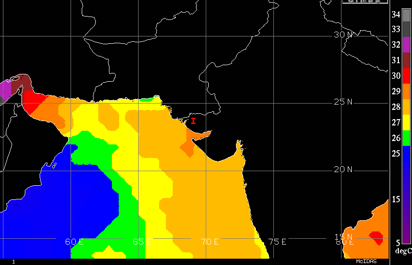
The winds in the inner ring of deep depression are likely to strengthen. The weather system over the sea with winds in the range of 62-88 km is classified as cyclonic storms. The cloud structure of the deep depression supports formative banding with embedded convection. The sea surface temperature is warm enough at 28-29°C. Vertical wind shear is moderate and favours deepening of the system to a cyclonic storm. The cyclone is expected to move away from the Indian coastline and therefore no threat of stormy conditions is likely for Saurashtra & Kutch. As the storm moves westward, the sea surface temperature is reduced. Therefore, the decreasing heat potential may weaken the system, as it tracks towards the Persian Gulf and Strait of Hormuz.
The deep depression, if intensifies into a storm, will be named ‘ASNA’ as proposed by Pakistan. The storms in the Indian seas are not very common during the southwest monsoon season. This may as well be treated as an outlier. The last storm during this year was over the Bay of Bengal in May 2024. The cyclone ‘REMAL’ as named by Oman had struck the Bangladesh-West Bengal border in the Sundarban area on 26th May 2024.
Image Courtesy: India Today