Cyclonic Storm Luban continues to threat Oman and Yemen Coast

October 13, 2018 2:37 PM|

artttt

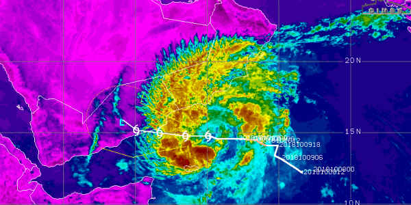
The Cyclonic Storm ‘LUBAN’ over West central Arabian Sea moved west wards during the past 6 hours and centered over West central Arabian Sea, near latitude 14.8°N and longitude 56.0°E, about 320 km southeast of Salalah (Oman), 330 km northeast of Socotra Islands (Yemen), 440 km east-southeast of Al-Ghaidah (Yemen) and 720 km east-northeast of Riyan (Mukalla).

Further also, it is very likely to move west-northwestwards and cross Yemen Coast between Riyan (Mukalla) and Al-Ghaidah (Yemen), close to 15°N during noon/afternoon of October 14, 2018 as a severe cyclonic storm.

Therefore, we expect, Gale wind speed reaching 70-80 kmph gusting to 90 to prevail over West central Arabian Sea around the systems center. Gale wind speed reaching 90-100 kmph gusting to 120 are very likely along & off Yemen & adjoining South Oman Coast at the time of landfall.

In fact, the sea conditions will be dangerous over West central Arabian Sea off South Oman and Yemen Coast and also over Gulf of Aden till October 14 evening and will improve rapidly thereafter.

The fishermen are advised not to venture into West central Arabian Sea off South Oman and Yemen coast and over Gulf of Aden till October 14.

Image Credits – cimss

Please Note: Any information picked from here must be attributed to skymetweather.com

Similar Articles

thumbnail image
March 20, Today Marks The Spring Equinox: Day-Night Duration Nearly Equal

The official transition from winter to spring, known as the SPRING EQUINOX, occurs today! It’s time when the Sun crosses the celestial equator precisely at 2:31 PM, delivering warmer, longer days to the Northern HemiSphere. As autumn arrives, the South enjoys colder evenings.

posted on:
thumbnail image
आज सूर्य करेगा भूमध्य रेखा पार, बसंत ऋतु की शुरुआत, दिन-रात की अवधि लगभग बराबर

आज, 20 मार्च 2025, बसंत विषुव (Spring Equinox 2025) का दिन है। सूर्य भूमध्य रेखा को पार करेगा, दिन बड़े और गर्म होंगे। उत्तर गोलार्ध में बसंत ऋतु की शुरुआत होगी, दक्षिण गोलार्ध में शरद ऋतु का आगमन होगा। वहीं, सितंबर में यह खगोलीय घटना फिर से होगी।

posted on:
thumbnail image
गर्मी का दायरा बढ़ा! ओडिशा, महाराष्ट्र, तेलंगाना और रायलसीमा में 40°C के पार तापमान, राहत की उम्मीद

देश में समय से पहले गर्मी असर बढ़ रहा है। ओडिशा, महाराष्ट्र, तेलंगाना, आंध्र प्रदेश में अभी तापमान से 40°C से ऊपर पहुंच गया है, जिस कारण इन राज्यों में भीषण गर्मी हो रही है। फरवरी 2025, पिछले 125 वर्षों में सबसे गर्म महीना रहा है। कई जगहों पर सामान्य से 6.4°C तक ज्यादा तापमान रिकॉर्ड हुआ है।

posted on:
thumbnail image
दिल्ली में बढ़ेगी गर्मी! शुष्क और तपता रहेगा वीकेंड, बारिश की संभावना हुई कम

दिल्ली में गर्मी बढ़ रही है, पिछले 3 दिनों में तापमान 4°C बढ़ा है। आज अधिकतम 34-35°C, न्यूनतम 17°C तक रह सकता है। मार्च अब तक लगभग शुष्क बना हुआ है, सिर्फ 2mm बारिश दर्ज हुई है। 26-28 मार्च को तापमान 40°C के करीब पहुंचने की संभावना है। वहीं,पश्चिमी विक्षोभ से मैदानी इलाकों में बारिश की संभावना नहीं है।

posted on: