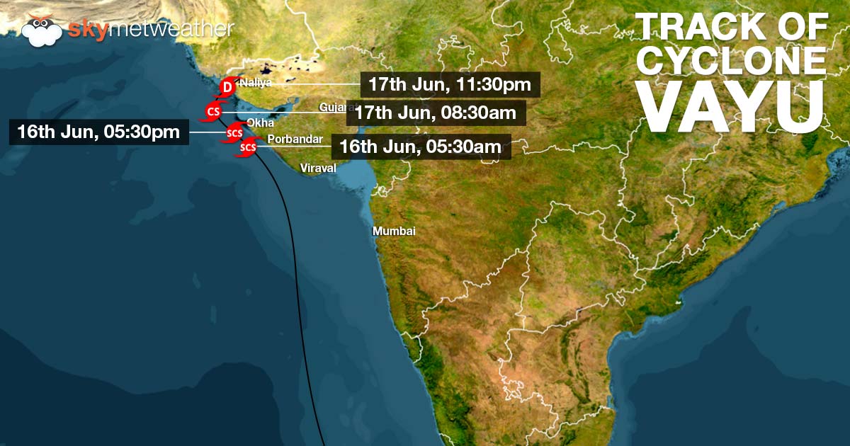
The SevereCyclonic Storm Vayu over Northeast and adjoining northwest and Central Arabian Sea is now moving in unfavourable weather conditions. In wake of this, Vayu is likely to weaken into a cyclonic storm by tonight.
Thesystem is presently centeredat latitude 20.9°N and longitude 65.1°E, around 460 km west-southwest of Porbandar, 420 km west-southwest of Dwarka and 530 km west-southwest of Bhuj.
The system has been tracking west-northwestwards but would now gradually start changing its direction towards north.Thereafter, re-curving towards northeast direction and moving towards the coast.
As the coast nears, the system would start weakening on account of increasing vertical wind shear and cold sea surface temperature. According to weathermen, the system would weaken into a deep depression and thereafter, into a depression by Monday.
Vayu is likely to make landfall over Kutch region i.e. north Gujarat coast as a depression by midnight of June 17.
Although at present the system is too far from Gujarat coast togive some rains on Sunday, but Sea conditions would be rough to very rough along and off Gujarat coast till June 17.
However, as Vayu nears the coast by Monday, we can expect widespread rainfall at many places of Saurashtra and Kutch region of Gujarat with some heavy showers over some places. Rains would also cover parts of South Rajasthan as well.
Rains over the Saurashtra and Kutch and South Rajasthan would increase by June 18 where in we expect some heavy to very heavy rains at one or two places.
The Severe Cyclonic Storm Vayu over Northeast and adjoining northwest and Central Arabian Sea is now moving in unfavourable weather conditions. In wake of this, Vayu is likely to weaken into a cyclonic storm by tonight.
The system is presently centered at latitude 20.9°N and longitude 65.1°E, around 460 km west-southwest of Porbandar, 420 km west-southwest of Dwarka and 530 km west-southwest of Bhuj.
The system has been tracking west-northwestwards but would now gradually start changing its direction towards north.Thereafter, re-curving towards northeast direction and moving towards the coast.
As the coast nears, the system would start weakening on account of increasing vertical wind shear and cold sea surface temperature. According to weathermen, the system would weaken into a deep depression and thereafter, into a depression by Monday.
Vayu is likely to make landfall over Kutch region i.e. north Gujarat coast as a depression by midnight of June 17.
Although at present the system is too far from Gujarat coast to give some rains on Sunday, but Sea conditions would be rough to very rough along and off Gujarat coast till June 17.
However, as Vayu nears the coast by Monday, we can expect widespread rainfall at many places of Saurashtra and Kutch region of Gujarat with some heavy showers over some places. Rains would also cover parts of South Rajasthan as well.
Rains over the Saurashtra and Kutch and South Rajasthan would increase by June 18 where in we expect some heavy to very heavy rains at one or two places.
Image Credit: NDTV
Any information taken from here should be credited to skymetweather.com