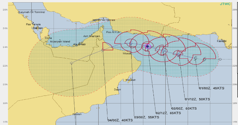
The much anticipated cyclone Shaheen has developed over warm waters of Arabian Sea. The storm is centered about 23.2°N and 65°E, about 350km west-northwest of Dwarka (Gujarat) and 650km east-northeast of Masirah island.
The cyclone is packed with winds of the order of 80 kmph and has moved with a speed of about 12kmh in the past 6hr. It is moving west-northwestward over the open waters of Arabian Sea. The storm is coasting nearly parallel to the Makaran coast, positioned about 250 km south-southwest of Karachi.
Cyclone Shaheen is a sequel of tropical storm Gulab, which formed over Bay of Bengal on 26th Sep and crossed Andhra Pradesh coast near Srikakulam. The weakened storm travelled across Chhattisgarh and Maharashtra and its remnant entered Gulf of Cambay and Saurashtra. The weather system got rejuvenated again and turned in to a cyclone, in quick succession of Gulab.
The storm is expected to intensify in to a severe cyclonic storm in the next 36hr. Thereafter, the storm may steer west-southwestward towards Gulf of Oman. Dry air entrainment may weaken it back to a cyclonic storm.
Further, the storm will head for Oman coast and make landfall on 03rdOctober. Land interaction and increased vertical wind shear may weaken the weather system slightly before crossing the coast.
The cyclone is at a safe distance from Gujarat coast and rather far away from the oil rigs over Bombay High. Presence of cyclone may increase the wind speed marginally over the open seas and the wave height also go up by couple of feet.
However, intense rains and gale speed winds are ruled out for the duration of this storm over the area. Also, entire state of Gujarat will remain free from any significant weather activity for the next 3 days. Passage of this storm and the resultant change in the wind pattern will set the process of withdrawal of monsoon in motion.


