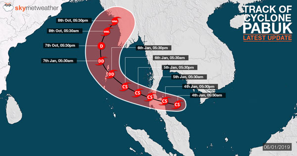
Updated on January 7 – Heavy rains over Andaman and Nicobar Islands likely; no affect to Indian mainland
At 8:30 hours IST, on January 6, the cyclonic storm Pabuk lays centered at 11.1˚ North and 94.6˚ East about 210 km east/southeast of Port Blair Island. This system would further be moving in west/northwest direction and weakening into a deep-depression after 6 hours. The surface winds are likely to be between 55 to 65 kmph, gusting up to 75 kmph.
This same system would be crossing Andaman and Nicobar Islands towards the night of January 6. Further, this system would be moving in north/northwest direction and weakening into a depression towards early morning hours on January 7.
Later, this same weather system is likely to recurve towards northeast direction and cross Myanmar coast on January 8 as a well-marked low-pressure area.
In wake of the above system, during the last 24 hours, moderate to heavy rains and strong winds occurred over many places of Andaman and Nicobar Islands.
Further also during the next 24 hours, we expect moderate to heavy rains accompanied with strong gusty winds to occur over many places of Andaman and Nicobar Islands.
Updated on January 6 - Cyclone Pabuk to hit Andaman and Nicobar Islands by today forenoon, to spare Indian mainland
Year 2018 was a very hectic year for the Indian Seas in terms of tropical disturbances. There were around 14 systems that had formed in the last season starting from Depression which is of low intensity to extremely Severe Cyclonic Storm. This included two Cyclonic Storms, two Severe Cyclonic Storms, two very Severe Cyclonic Storms and one extremely Severe Cyclonic Storm.
We saw all the four categories of storms during the last season.Cyclone Mekunuwas an extremely Severe Cyclonic Storm whereasCyclone Lubanwas a very Severe Cyclonic Storm. These two cyclones had formed in the Arabian Sea and did not have direct impact on the Indian coast. Cyclone Titli had formed in the Bay of Bengal in the month of October and had direct impact on the Indian mainland.
For Indian Seas, months of January and February are not considered favourable for the formation of cyclones. Statistics for the cyclones pertain only from the month of March up till December. We don’t see any data for January and February.
However, there seems an exception for the Indian Seas this time, as a storm is soon reaching the Andaman Sea and that too in the month of January.Storm Usmanhas wreaked havoc over Philippines around New Year’s Eve, claiming over 64 lives and resulting in widespread destruction. Thereafter, the system weakened into a depression and moved into the South China Sea where it once again picked up pace, becoming a Cyclonic Storm Pabuk yet again on Thursday.
Presently, it lay centered at 0530 hours IST of today,i.e. on January 5, 2019 over Thailand and neighbourhood near latitude 8.9°N and longitude 98.7°E, about 720 km east-southeast of Port Blair. It is very likely to move west-northwestwards and emerge into Andaman Sea by forenoon of today.
After entering Andaman Sea, it will then move towards north and reach Port Blair by January 6 evening as a cyclonic storm only. As per Skymet Weather, the conditions seem favorable in terms of heat potential to intensify the strength of the storm. But the moment, it crosses Port Blair, it will start losing it’s strength as the temperatures will drop and wind shear will increase.
It is then expected to re-curve and move northeastwards towards Myanmar and thus, this storm seems to pose no threat to our Indian mainland. On January 7, the system will continue to move in open waters but by January 8, it is expected to touchdown at Myanmar. But by this time, it would eventually start losing it’s strength and might end up as a Well-marked low-pressure area only by the time it reaches Myanmar.
The sea condition will be high over Andaman Islands, Andaman Sea and adjoining areas of east-central and southeast Bay of Bengal from the evening of January 5 till the morning of January 7.Thereafter, it will become very rough over southeast Bay of Bengal, Andaman Islands and adjoining Andaman Sea and east-central Bay of Bengal by January 8 morning and rough over east-central and adjoining southeast Bay of Bengal by January 8 evening. The sea condition will be very rough over Nicobar Islands till January 6.
People in Andaman Islands are advised to remain in safe places.Total suspension of fishing operation over Andaman Sea and adjoining southeast and east-central Bay of Bengal during January 5-7 and over east-central & adjoining southeast Bay of Bengal on January 8.Fishermen are advised not to venture into Andaman Sea and adjoining southeast and east-central Bay of Bengal during the same period.
Image Credit: Skymet
Please Note: Any information picked from here must be attributed to skymetweather.com


