Updated on November 6, 2019, 11:45 AM: Very Severe Cyclone Maha is now Severe Cyclone, threat to Gujarat coast continues
As had been forecast by Skymet,Cyclone Maha recurved towards Gujarat coast last night. Moreover, until today morning the Very Severe Cyclone has reduced into a Severe Cyclone and lies near 19.8 N and 66.3 E about 400 km West-southwest of Porbandar, and 440 km West-southwest of Veraval and 490 km West southwest of Diu.
The SevereCyclone is expected to weaken further into a Cyclonic Stormsoon. There are good chances that the Cylone Maha will fizzle out before reaching the coast. It may reach the coast as a Well Marked Low Pressure Area or a Low-Pressure Area.
However, the threat of Cyclone cannot be completely ruled out from the Gujarat coast as the system will near South Gujarat coast by tomorrow noon. The wind speed will be around 40-50 km gusting to 60-70 km per hour.
Updated on November 5 2019, 10:01 AM: Extremely Severe Cyclone Maha to bring heavy rain in Gujarat and Maharashtra as it crosses Gujarat Coast by Nov 7

According to our meteorologists, the intensity of Cyclone Maha is expected to remain intact for another 12 hours and thereafter the system is likely to lose its strength. It would continue to move in north direction during the next 12 hours and thereafter would increase its speed and start moving rapidly in east/northeast direction.
After following this path, Cyclone Maha is likely to cross Gujarat Coast somewhere between Diu and Porbandar, most probably by November 7. It would maintain the speed of 80-90 kmph, gusting up to 100 kmph.
As a result, light to moderate rains along with a few to very heavy spells are likely in the region of Saurashtra and Gujarat on November 6. In fact, scattered light rain would commence from November 5 only, which would gradually increase by the time.
The effect of Cyclone Maha would also be seen in the form of light to moderate rain along with isolated heavy spells in North Madhya Maharashtra and the North Konkan region on November 6 and 7. From the morning of November 6, squally winds of 40-50 kmph gusting to 60 kmph are likely to blow along and off Maharashtra Coast.
Updated on November 4 2019, 13:43 PM: Extremely Severe Cyclone Maha to make landfall in Gujarat
The fourth Cyclone “Maha” in the Arabian Sea has further intensified into an Extremely Severe Cyclone at 0530 IST today. It is still traveling in favourable sea conditions where temperatures are around 29 degrees Celsius and vertical wind shear is low between 5-10 knots.
It is likely to turn in a northerly direction and thereafter recurve in east-northeast direction by tomorrow morning. After recurving, it will start traveling in relatively unfavourable sea conditions as the vertical wind shear will also start increasing and sea surface temperature will also decrease. Also, the dry westerlies northwesterlies will start penetrating and will cut off the moisture feed from the sea. Due to this, Cyclone Maha will weaken on its way to the Gujarat coast. The strong westerly winds will further weaken and will reach the Gujarat coast as either a Severe Cyclone or Cyclone. The system is likely to make a landfall between Diu and Porbandar around November 7 and at that time the wind speed will be around 80-90 kmph gusting 100 kmph.
Updated on November 3, 2019, 10:50 AM: Severe Cyclone to become Very Severe anytime soon
Severe Cyclone Maha continues to move in Northwest direction away from the Indian coast. The Cyclone might intensify into a Very Severe Cyclone by today evening. By tomorrow evening, we expect this to recurve in East-northeast directiontowards Gujarat and Maharashtra coast. At 17:30 hrs on November 2 the system is located near latitude 17 N and 67.3 E. Geographically it is located 550 km South-southwest of Veraval and 540 km South-southwest of Diu. As it moves towards India, the cyclone will keep weakening. There are slight chances that the Cyclone might even degenerate into a Deep Depression while it makes landfall over Gujarat.
Updated on November 2, 2019, 12:26 PM: Severe Cyclonic storm Maha to impact Gujarat now
The Severe Cyclonic Storm 'Maha' over the east-central Arabian Sea moved further northwestwards and lay centered at 0530 hours IST of today over the east-central Arabian Sea near Latitude 16.3°N and Longitude 68.5°E, about 550 km south-southwest of Veraval (Gujarat) and 570 km west-northwest of Goa. It is very likely to move west-northwestwards till November 04 and recurve east northeastwards towards south Gujarat coast due to strong Trough in the form of northwesterly over the area. It is very likely to intensify into a Very Severe Cyclonic Storm over the east-central Arabian sea during the next 48 hours.
The coastal stations of North Konkan and South Gujarat will continue to witness moderate to strong gusty winds and high waves of around 10 feet during the next 24 hours. Thereafter, the intensity of wind speed would decrease but may pick up the pace again around November 6 and 7. Mainly light to moderate rain and thundershower is expected in South Gujarat and North Maharashtra for the day.
Updated on November 1, 2019 11:00 AM: Severe Cyclone Maha to become very severe cyclone anytime now
After intensifying intoSevere Cyclonic Storm Mahaover east-central Arabian Sea and adjoining Lakshadweep area is now all set to become more powerful and intensify into a very severe cyclone by Friday evening.
Moving in north-northwest direction, the system is presently centered at Latitude 14.6°N and Longitude 71.7°E over eastcentral Arabian Sea around 310 km north of Cheriapani Reef, Lakshadweep, 420 km north-northwest of Amini Divi and 390 km west-northwest of Mangaluru, Karnataka.
According to weathermen, the system would continue to track in same direction of north-northwestwards for next few hours. Thereafter, it would follow the same route as Cylone Kyarr and move west-northwestwards.
With system moving away from the Indian coast, we do not expect this powerful system to have direct impact on the coastal areas of Kerala, Karnataka andKonkan& Goa. However, with peripherals reaching the West Coast, light to moderate rains cannot be ruled out along the coastal areas. There would be major relief from extremely heavy rains over Lakshadweep Islands which would now see only moderate rains. However, strong surface winds would persist.
Sea conditions would remain rough to very rough. Thus,complete suspension of fishing operationsfor the next 24 hours for along & off Lakshadweep Islands, Karnataka, Goa and Maharashtra coasts. In fact, fishermen are not advised to venture out in the sea till November 6.
Updated on October 31, 2019 2:40 PM: Cyclone Maha gets more marked, to become severe cyclone anytime now
The Cyclonic Storm Maha continues to move across Lakshadweep and adjoining southeast Arabian Sea, while getting more marked. According to weathermen, the system is travelling in conducive atmosphere of low vertical wind shear and warm sea surface temperatures (SST). With this, Maha is likely to intensify into a severe cyclonic storm anytime now.
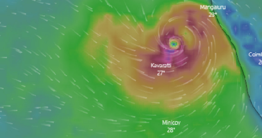
At present, the system is centered at Latitude 11.5°N and Longitude 72.8°E over Lakshadweep and adjoining southeast Arabian Sea, around 40 km north-northeast of Amini Divi, 350 km north-northwest of Minicoy, 110 km north-northeast of Kavaratti and 325 km west-northwest of Kozhikode.
Cyclone Maha continues to track north-northwestwards at a fast pace with the speed of 17 kmph. By the wee hours of Friday, Maha would reach east-central Arabian Sea, from where it would move west-northwestwards. With long sea travel ahead, it is very likely to intensify into a Very Severe Cyclonic Storm in the next 24 hours.
Updated on October 31, 2019 1:10 PM: Checkout the likely track of Cyclone Maha

Updated on October 31, 2019 12:30 PM: Cyclone Maha gives record-breaking rains over Lakshadweep Islands during the last 24 hours. Amini Divi received 301 mm rains, which is not only the highest rainfall ever witnessed during the 24 hours as well as highest rainfall recorded during the entire month in last 10 years. Minicoy has also broken 24 hours rainfall record with 119 mm rains, that earlier stood at 92.4 mm recorded on October 23, 2012.
According to Skymet Weather, red alert has been issued for Lakshadweep Islands as Cyclone Maha is moving across the islands. It is most likely to further intensify into a Very Severe Cyclone by today evening. With this, heavy to very heavy rains would continue to batter Lakshadweep for another 24 hours, with more intensity over northern islands.
Updated on October 31, 2019 11:30 AM: Cyclone Maha has been moving in a North-Northwest direction at 15 kmph during past 06 hours and was near Lat. 11.0 °N and Long. 73.0 °E over Lakshadweep and adjoining southeast Arabian Sea, 30 km ESE of Amini Divi, 300 km N of Minicoy, 60 km NNE of Kavaratti and 300 km WSW of Kozhikode.
The Cyclone is expected to continue to follow a northnorthwest direction across Lakshadweep in the next few hours and will emerge again in the East-central Arabian Sea during subsequent 12 hours, moving in a west-northwest direction.

There are very bright chances thatMaha will concentrateinto a Severe Cyclonic Storm during the next few hours over Lakshadweep region and further become a Very Severe Cyclonic Storm after it remerges in the East-central Arabian Sea.
Talking about the rainfall activities,Amini Divi in Lakshadweephas already recorded a whopping 301 mm of rains while Minicoy saw 119 mm of rains, resulting in red alert for the island.
Now, heavy to extremely heavy rains are expected to lash the Lakshadweep Islands today with rainfall remaining heavy over the coastal parts of Kerala as well as Karnataka. Moreover, heavy rains may also be seen over Tamil Nadu and a few parts of Rayalaseema.
As the storm will move away from the coast by tomorrow, there is likely to be a reduction in rainfall activities from southern parts of the country.
Image Credit: Windy
Please Note: Any information picked from here must be attributed to skymetweather.com


