Cyclone Burevi hits Sri Lanka, enters Gulf of Mannar, landfall likely near Pamban

December 3, 2020 2:57 PM|

Cyclone Burevi

Cyclone Bureviis positioned now over Gulf of Mannar and is heading for Tamil Nadu coast. The storm moved nearly westward with a speed of 12kmph in the past 6 hours and is nearing the coastline of Tamil Nadu. The storm will reach very close to Tondi by today evening and thereafter shift along the coast slowly moving west-southwest. It is likely to make its 2nd landfall close to Pamban in the late night (03rd December) or wee hours of 04th December.

Cyclone Burevi

The cyclone earlier made its first landfall on 02nd December north of Trincomalee and moved near Mannar by 03rd December early morning. North Sri Lanka witnessed heavy downpour with Trincomalee recording 167mm rainfall, Jaffna 245mm and Mannar 190mm in 24 hours. The outer bands of the storm reached Tamil Nadu coast to inflict heavy rainfall overKaraikal164mm,Nagapattinam143mm,Cuddalore66mm,Puducherry76mm, andChennai46mm.

Cyclone Burevi

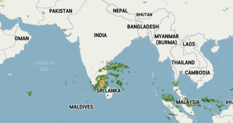
Heavy to very heavy rainfall accompanied with squally winds (70-90kmph) is likely over Nagapattinam, Pamban, Tondi, Tuticorin,Ramanathapuram, Thoothukudi, and Kanyakumari. The interiors of Tamilnadu like Trichy, Thanjavur andMaduraialso will witness heavy rainfall on 03rd and 04th December. Southern parts of Kerala will have very heavy rainfall commencing 04th December morning.Thiruvananthapuram,Alappuzha,Punalur,Kochi,Idukki, andKottayamare likely to witness incessant rains with gale winds in excess of 70kmph.

Intense weather is likely to continue over these parts on 5th December and relief is expected 6th December onward. The remnant of Burevi is likely to move over to Southeast Arabian sea on 6th December and move further westward away from the coastline in the subsequent 48 hours. Later this weather system may head for Somalia coast.

Similar Articles

thumbnail image
March 20, Today Marks The Spring Equinox: Day-Night Duration Nearly Equal

The official transition from winter to spring, known as the SPRING EQUINOX, occurs today! It’s time when the Sun crosses the celestial equator precisely at 2:31 PM, delivering warmer, longer days to the Northern HemiSphere. As autumn arrives, the South enjoys colder evenings.

posted on:
thumbnail image
आज सूर्य करेगा भूमध्य रेखा पार, बसंत ऋतु की शुरुआत, दिन-रात की अवधि लगभग बराबर

आज, 20 मार्च 2025, बसंत विषुव (Spring Equinox 2025) का दिन है। सूर्य भूमध्य रेखा को पार करेगा, दिन बड़े और गर्म होंगे। उत्तर गोलार्ध में बसंत ऋतु की शुरुआत होगी, दक्षिण गोलार्ध में शरद ऋतु का आगमन होगा। वहीं, सितंबर में यह खगोलीय घटना फिर से होगी।

posted on:
thumbnail image
गर्मी का दायरा बढ़ा! ओडिशा, महाराष्ट्र, तेलंगाना और रायलसीमा में 40°C के पार तापमान, राहत की उम्मीद

देश में समय से पहले गर्मी असर बढ़ रहा है। ओडिशा, महाराष्ट्र, तेलंगाना, आंध्र प्रदेश में अभी तापमान से 40°C से ऊपर पहुंच गया है, जिस कारण इन राज्यों में भीषण गर्मी हो रही है। फरवरी 2025, पिछले 125 वर्षों में सबसे गर्म महीना रहा है। कई जगहों पर सामान्य से 6.4°C तक ज्यादा तापमान रिकॉर्ड हुआ है।

posted on:
thumbnail image
दिल्ली में बढ़ेगी गर्मी! शुष्क और तपता रहेगा वीकेंड, बारिश की संभावना हुई कम

दिल्ली में गर्मी बढ़ रही है, पिछले 3 दिनों में तापमान 4°C बढ़ा है। आज अधिकतम 34-35°C, न्यूनतम 17°C तक रह सकता है। मार्च अब तक लगभग शुष्क बना हुआ है, सिर्फ 2mm बारिश दर्ज हुई है। 26-28 मार्च को तापमान 40°C के करीब पहुंचने की संभावना है। वहीं,पश्चिमी विक्षोभ से मैदानी इलाकों में बारिश की संभावना नहीं है।

posted on: