

As predicted, the deep depression in Bay of Bengal finally intensified into a cyclonic storm Bulbul on Thursday morning. This is the seventh cyclone of the season, while first for the Bay of Bengal during the post-Monsoon season.
The system is presently marked over east-central Bay of Bengal and centered near 14.7°N and Longitude 90°E, about 680 km south-southeast of Paradip, Odisha, 775 km south-southeast of Sagar Islands, West Bengal and 800 km south-southwest of Khepupara, Bangladesh.
Cyclone Bulbul would continue to track north-northwestwards in favourable weather conditions and further strengthening into a severe cyclonic storm soon. In fact, chances are bright for the system to even intensify into a very severe cyclonic storm in the next 24 hours. It is expected to make landfall around November 10 between Chandbali and Sagar Island.
According to weathermen, Bulbul would continue to move in the sea for the next three days, before re-curving. It would then move along the East Coast, possibly skirt the North Odisha and West Bengal coast.
So far, there has been fair amount of agreement among the various weather models worldwide over the track of Cyclone Bulbul and its intensification. However, there is disagreement over its landfall. Let us have a look at the same:
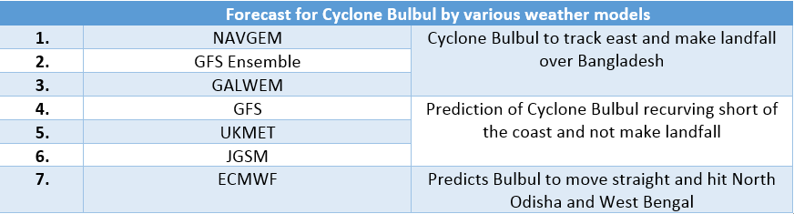
As per weathermen, environmental features are such that lead to lots of uncertainty in its track. However, climatology suggests that most of the tropical storms forming in Bay of Bengal during this time of the year usually threaten the Odisha coast but they re-curve short of that, skirt the coast and head for Bangladesh. We at Skymet Weather also believe that Bulbul is most likely to head either for West Bengal or Bangladesh.

Heavy Rain alert:
November 7: At present, Bulbul is well away from the coast, but such powerful systems tend to effect the weather over the coast. Today, we can expect light rains with few moderate rainfall over North Coastal Odisha and West Bengal. Rains would be accompanied with strong surface winds to the tune of 50-60 kmph gusting up to 70 kmph. Also, very light rains can also be wished over Coastal Andhra Pradesh.
November 8: With Cyclone Bulbul inching closer as well as intensifying, rains as well as surface winds would too pick up pace. Moderate with heavy spells are likely to lash coastal parts of North Odisha and West Bengal, with strong surface winds of 70-80 kmph gusting up to 90 kmph.
November 9 & 10: By this time, Bulbul would be quite closer to the Indian coast as well as also recurving. This would slowdown its pace, resulting in prolonged and intense rains. Thus, heavy to very heavy rains would lash North coastal Odisha and West Bengal on November 9 and 10. This would be accompanied with damage potential winds of 80-90 kmph gusting up to 100 kmph.
Once again we would reiterate that places like Chandbali, Puri, Gopalpur, Balasore, Diamond Harbour, Digha and Canning would be most impacted. In fact, areas such as Baripada, Midnapore, Kolkata, Bhubaneswar might also see heavy rains.
Meanwhile, sea conditions would remain rough to very rough all along the East Coast. Complete suspension of fishermen activities are advised along and off Odisha and West Bengal coast from November 8-10.
Image Credit: NDTV
Any information taken from here should be credited to skymetweather.com
