Brewing system in the Bay of Bengal to keep Monsoon active over Andhra Pradesh and Telangana

September 21, 2019 12:53 PM|

Rain in Andhra Pradesh and Telangana

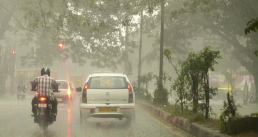
The wind shear zone is moving across North of Telangana and Andhra Pradesh. Along with this system, a Cyclonic Circulation persists over the North Andhra Pradesh coast. Due to the combined impact of these two systems, therainfall will continuemainly over the northern parts of the Telangana and Andhra Pradesh coasts. Even in the last 24 hours as well, moderate to heavy rains have been witnessed in many places.

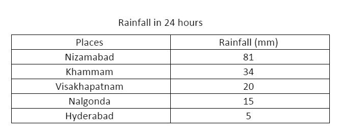
The significant rains have been recorded atNizamabad 81 mm, Khammam 34 mm, Visakhapatnam 20 mm, Nalgonda 15 mm with light rains over Hyderabad of 5 mm.

Rainfall in last 24 hours in AP and Telangana

For the next few days, rainfall activity will continue with mainly moderate spells with heavy rains in isolated pockets. During the next 24 hours, isolated heavy spells are likely over Khammam, Ramagundam, Nalgonda, Bhadrachalam,Rentachintala, Anantapur, Cuddapah, Kurnool, and Tirupati.

Whereas light rains will be seen over rest places of these two states. If we talk about the present condition, then the weather is pleasant with persistent thick clouding and a light breeze. Along with this, moderate lightning strikes are expected along the coast.

Another Cyclonic Circulation which is likely to develop in the south-central Bay of Bengal is likely to move northwestwards and is expected to reach the South Andhra Pradesh coast by September 24. This system stands a chance to enhance the rainfall activities with heavy spells at some places of Telangana and Rayalaseema. Looks like Active Monsoon conditions will continue to persist for almost the rest of September.

Image Credits – The Hans India

Any information taken from here should be credited to Skymet Weather

Similar Articles

thumbnail image
March 20, Today Marks The Spring Equinox: Day-Night Duration Nearly Equal

The official transition from winter to spring, known as the SPRING EQUINOX, occurs today! It’s time when the Sun crosses the celestial equator precisely at 2:31 PM, delivering warmer, longer days to the Northern HemiSphere. As autumn arrives, the South enjoys colder evenings.

posted on:
thumbnail image
आज सूर्य करेगा भूमध्य रेखा पार, बसंत ऋतु की शुरुआत, दिन-रात की अवधि लगभग बराबर

आज, 20 मार्च 2025, बसंत विषुव (Spring Equinox 2025) का दिन है। सूर्य भूमध्य रेखा को पार करेगा, दिन बड़े और गर्म होंगे। उत्तर गोलार्ध में बसंत ऋतु की शुरुआत होगी, दक्षिण गोलार्ध में शरद ऋतु का आगमन होगा। वहीं, सितंबर में यह खगोलीय घटना फिर से होगी।

posted on:
thumbnail image
गर्मी का दायरा बढ़ा! ओडिशा, महाराष्ट्र, तेलंगाना और रायलसीमा में 40°C के पार तापमान, राहत की उम्मीद

देश में समय से पहले गर्मी असर बढ़ रहा है। ओडिशा, महाराष्ट्र, तेलंगाना, आंध्र प्रदेश में अभी तापमान से 40°C से ऊपर पहुंच गया है, जिस कारण इन राज्यों में भीषण गर्मी हो रही है। फरवरी 2025, पिछले 125 वर्षों में सबसे गर्म महीना रहा है। कई जगहों पर सामान्य से 6.4°C तक ज्यादा तापमान रिकॉर्ड हुआ है।

posted on:
thumbnail image
दिल्ली में बढ़ेगी गर्मी! शुष्क और तपता रहेगा वीकेंड, बारिश की संभावना हुई कम

दिल्ली में गर्मी बढ़ रही है, पिछले 3 दिनों में तापमान 4°C बढ़ा है। आज अधिकतम 34-35°C, न्यूनतम 17°C तक रह सकता है। मार्च अब तक लगभग शुष्क बना हुआ है, सिर्फ 2mm बारिश दर्ज हुई है। 26-28 मार्च को तापमान 40°C के करीब पहुंचने की संभावना है। वहीं,पश्चिमी विक्षोभ से मैदानी इलाकों में बारिश की संभावना नहीं है।

posted on: