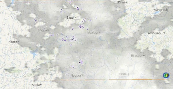
Madhya Pradesh has been witnessing hefty rains from the past few days. During the last 24 hours active with isolated vigorous Monsoon conditions prevailed over the region. The entire state recorded good rainfall activities leading to pleasant weather conditions.
[yuzo_related]
As per Skymet Weather, the cyclonic circulation over Chhattisgarh and the axis of Monsoon trough passing across the state can be attributed for the hefty rains. In the last 24 hours from 8.30 am on Friday, Indore witnessed 48 mm of heavy rain, Khandwa 31 mm, Ratlam 25 mm and Ujjain 24 mm of rain. In the same span of time, Dhar recorded 17 mm of rain and Seoni 11 mm of moderate intensity rainfall.
Bhopal observed light rain of 5 mm, Betul 6 mm and Raisen 6 mm. At present, the cyclonic circulation over Chhattisgarh is likely to move in a westerly direction and this cyclonic circulation is extending up to mid tropospheric level.
Click the image below to see the live lightning and thunderstorm across Madhya Pradesh
The axis of Monsoon is moving from extreme North Rajasthan across Madhya Pradesh and Chhattisgarh towards East central Bay of Bengal. It is anticipated that moderate to heavy rain will continue during the next 24 hours like Ratlam, Dhar, Bhopal, Indore, Ujjain, and Hoshangabad.
The rainfall activities are likely to reduce after 24 hours over the southeastern parts of the state. As on August 25, West Madhya Pradesh is rain deficient by 21 percent and East Madhya Pradesh by 25 percent. Due to these hefty rains, the rainfall deficiency is likely to reduce.
IMAGE CREDIT: metovisa.com
Any information taken from here should be credited to skymetweather.com


