Close on the heels of triple dip La Nina, Pacific warming has now accelerated. Fears are being expressed of an early and strong El Nino during the monsoon season. As per National Oceanic and Atmospheric Administration (NOAA) researchers, the magnitude of the predicted El Nino shows a very large spread. While it is not very rare to find El Nino after La Nina, but it is certainly abnormal to have extreme ones so close together. The last big one was witnessed in 2015-16 and having another 'jumbo' event with in 7 years is rather unusual.
The monthly update issued by NOAA has pointed to a sharp increase in the probability of 62% in the quarter MJJ( May-Jun-Jul), 75% in JJA (Jun-Jul-Aug) and cross 80% mark in the subsequent quarters of JAS and ASO. It is frightening, if turns true. Skymet has factored El Nino in its monsoon forecast but indices climbing to super El Nino level has not been catered for. The level of Nino indices will be monitored for the next 4-6 weeks, beyond the spring barrier.

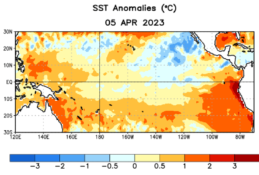
ENSO: Anomalous warming of waters in the eastern and central Pacific continue. As per latest update of ENSO from NOAA, El Nino may develop earlier than expected. This might as well be a strong El Nino, as against earlier forecast of mild to moderate event. The latest weekly Nino 3.4 index value was 0.0 deg but the Nino 1+2 index was +2.7 deg, pointing at speedy warming along the coast.


Above average sea surface temperatures (SST's) became more prominent in the western and far eastern Pacific Ocean. Overall, coupled ocean-atmosphere system is consistent with ENSO neutral, as of now. This state is likely to continue through the Northern Hemispheric spring and thereafter, rapidly transition to developing El Nino, at the start of monsoon in June.


IOD : JAMSTEC ( Japan Agency for Maritime-Earth Science & Technology ) uses the Dipole Mode Index (DMI) to monitor the IOD event. The DMI is based on difference in area- averaged monthly-mean SST deviation between the tropical Western Indian Ocean (50-70deg East, 10deg South-10 deg North : WIN) and the southeastern tropical Indian Ocean ( 90-110deg East, 10deg South-Equator : EIN) with monthly- mean SST deviations based on linear extrapolation with respect to the latest sliding 30 year mean for each calendar month.

Positive (negative) IOD events are identified when the three month running- mean DMI is +0.4deg or above (-0.4deg or below) for at least 3 consecutive months between June and November. The IOD is currently neutral. The IOD index value for the week ending 09 April 2023 was +0.21deg, which is in neutral bounds of +/- 0.4 deg. IOD event is likely to develop in the coming months. Forecast made at this time of the year has low accuracy. A strongly positive IOD can suppress the exacerbating effect of El Nino over the Indian sub-continent. However, the current projections do not support such an eventuality and the index seems to be sinking mid way through the monsoon season.

MJO : Madden Julian Oscillation has been very active since early March. Presently, it is over Western Pacific in phase 6&7. It is expected to transit through Africa to the Indian Ocean over the next 2 weeks. Its amplitude will reduce while approaching Phase 2. There is no likelihood of any tropical cyclone formation over the Indian seas during this period.
Since 1970, all the El Nino years have led to drought or deficient rains with the single exception of 1997. That year, strong positive IOD rescued the monsoon despite an extreme El Nino event in the Pacific. All the five droughts of this century have coincided with El Nino conditions. The strongest of El Nino was witnessed in 2015-16 and remember, 2016 remains the hottest year on record worldwide. The year 2016 was unusual as there were 15 adverse weather and climate events with losses exceeding $1 billion each across the United States. These events included drought, wildfire, four flooding events, eight severe storm events and a tropical cyclone. With 2023 being potentially obsessed with extreme El Nino year, we all need to buckle up , remain watchful and be prepared.


