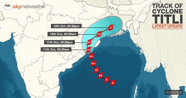
Cyclone Titli as Very Severe Cyclonic Storm had made a landfall at Palasa in Srikakulam, Andhra Pradesh and southwest of Gopalpur, Odisha on Thursday morning. At the time of hitting the coast, Gopalpur reported surface winds with speed exceeding 126 kmph.
Squally winds with speed of 70-80 kmph gusting up to 90 kmph would continue along and off Odisha and North Andhra Pradesh during the day. The system is presently seen prevailing East of Raigada, Odisha.
According to Skymet Weather, Cyclone Titli would start re-curving in northeast direction anytime now. Thus, districts of Puri, Jagatsinghpur, Kendrapada, Bhadrak, and Balasore would now come in the way of this cyclonic storm, braving some heavy to very rains along wit squally winds.
 It would further recurve in east-northeast direction towards Gangetic West Bengal by evening. However, in wake of long sea travel, Titli would start losing its strength gradually. By Thursday late afternoon, it would weaken into a severe cyclonic storm and by late Thursday night, it would weaken into deep depression. This would further travel to Northeast India.
In wake of this, moderate to heavy rains would continue over Gangetic West Bengal including Kolkata. By October 12, intensity of rains would increase wherein moderate to heavy with isolated very heavy rains are likely over West Bengal.
These rains would also be accompanied with gusty winds with the speed of 40 kmph-50 kmph gusting up to 60 kmph.
Image Credit:en.wikipedia.org
Any information taken from here should be credited to skymetweather.com


