Skymet weather

Delhi records seasons first highest maximum, relief likely soon

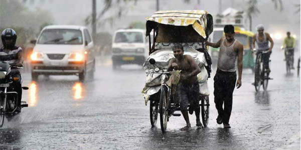
Delhi Rains-The Hindu 600

Updated on April 15 at 1800 hours

Today on April 15, Delhi witnessed it's first highest for this season both at Palam and Safdarjung Observatories. Palam recorded 41˚C while Safdarjung Observatory recorded 40˚C. However, good news is that in the wake of weather systems significant fall in mercury would be witnessed in the coming two days. It is expected that the temperatures can dip by four to five degrees and would settle somewhere around 32˚C to 34˚C.

Updated on April 15 at 1430 hours: Dust storm, rain in Delhi, Noida, Gurugram, Faridabad and Ghaziabad to bring relief from heat

Delhi and its adjoining areas such as Noida, Gurugram, Faridabad and Ghaziabad have been observing dry and heat wave like conditions since the last few days. Yesterday the maximum temperature recorded by Delhi’s Safdarjung Observatory was 38.1˚C.

Now a fresh Western Disturbance is approaching the Western Himalayas and it has induced a cyclonic circulation over parts of Rajasthan.

Therefore, today during the late evening or night hours, we expect patchy rains along with dust storm to occur in parts of Delhi and NCR. However, gradually by tomorrow the intensity and spread of these weather activities will increase.

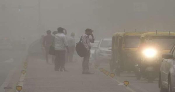
Thus, on April 16 and 17, we expect widespread rain and thundershowers with dust storm, thunderstorm and strong winds to affect many parts of Delhi, Noida, Gurugram, Faridabad and Ghaziabad.

In the wake of rains, both day and night temperatures over Delhi-NCR will drop. In fact, tomorrow and day after we can expect the National Capital Regions day temperatures to settle between 32˚C to 34˚C, which will be almost 5˚C below normal.

Further, from April 18 rains will start reducing and finally vacate the region by April 19. Thus, we can say that first good spell of rain and thundershowers is likely to occur over Delhi and NCR in the coming days, as we can even expect some intense showers in few pockets.

Image Credit: Wikipedia

Please Note: Any information picked from here must be attributed to skymetweather.com

[Hindi] पंजाब और हरियाणा में धूल भरी आँधी, ओलावृष्टि, बारिश की उम्मीद, गेहूं फसल क्षति का खतरा

Rain in Punjabपंजाब और हरियाणा में बारिश एक बार फिर से वापसी करेगी क्योंकि एक ताजा पश्चिमी विक्षोभ ने राजस्थान के पश्चिमी भागों पर हवाओं के चक्रवात को प्रेरित किया है। इसके साथ ही, पश्चिम उत्तर प्रदेश तक इस प्रणाली से एक ट्रफ देखी जा रही है।

इस प्रकार, धूल भरी तूफानी गतिविधियों के साथ आज शाम तक पंजाब और हरियाणा में गरज के साथ बारिश शुरू होने की संभावना है। इन क्षेत्रों में इन गतिविधियों में धीरे-धीरे वृद्धि देखी जाएगी।

वास्तव में, 16 अप्रैल को कई हिस्सों में मध्यम से भारी बारिश होने की संभावना है। ये गतिविधियां कल तक जारी रहने की उम्मीद है, यानी 17 अप्रैल। मौसम प्रणाली फिर से पूर्व की ओर बढ़ना शुरू कर देगी और तीव्रता काफी हद तक कम हो जाएगी।

हिंसक गरज और धूल भरी आँधी के साथ भारी बौछार हओ सकती हैं, जिसमें हवा की गति 50 किमी प्रति घंटे तक हो सकती है, जो की अलग-अलग हिस्सों में 60 किमी प्रति घंटे की रफ्तार तक बढ़ सकती है। कुछ क्षेत्रों में ओलावृष्टि की गतिविधियाँ भी देखने को मिल सकती हैं।

ये प्री-मॉनसून गतिविधियां गेहूं की खड़ी फसलों के लिए हानिकारक होंगी। गेहूं की कटाई कई हिस्सों में की गई है, लेकिन कुछ क्षेत्रों में अभी भी गेहूं की फसल नहीं हुई है। इस प्रकार, इन फसलों को तेज हवाओं, ओलावृष्टि और वर्षा की गतिविधियों के कारण नुकसान होगा।

कटाई की गई फसलें जो अभी तक संसाधित नहीं हुई हैं और अभी भी खेतों पर पड़ी हैं, उन्हें भी कुछ नुकसान होगा। इन बारिशों के कारण तापमान में भी गिरावट देखने को मिलेगी, और अधिकतम 30 डिग्री के आस पास दर्ज किए जाने वाले अधिकतम ताप मन में कमी आएगी। हालांकि, 17 अप्रैल के बाद अधिकतम तापमान एक बार फिर बढ़ेगा।

Image Credit:en.wikipedia.org

Any information taken from here should be credited to skymetweather.com

IMD forecasts near normal Monsoon 2019 at 96 percent of LPA

Monsoon Forecast 2019

India Meteorological Department has released its Monsoon Forecast to be near normal at 96 percent of the Long Period Average (LPA) with a model error of +/- 5%. The LPA of the season rainfall over the country as a whole for the period 1951-2000 is 890 mm.

 As per IMD, weak El Nino conditions will continue to prevail throughout the Monsoon season with the intensity to reduce during the latter part of the Southwest Monsoon 2019 season.

IMD also said that the sea surface temperature (SST) over the Pacific, i.e. El Niño/La Niña conditions along with the Indian Ocean Dipole-IOD in Indian Oceans greatly affect the Indian Monsoon, are being monitored closely enough. Moreover, the country is likely to observe well distributed rainfall during Monsoon 2019.

IMD has also mentioned that these rains will be quite beneficial to the farmers in the country during the kharif season.

IMD is expected to come out with its second stage of Monsoon 2019 Forecast in the first week of June. Also, the onset dates will be mentioned around May 15 by the India Meteorological Department.

Also Read: Skymet Forecasts Monsoon 2019 to be below normal at 93 percent of LPA

1. Background

India Meteorological Department (IMD) issues forecast for the Southwest Monsoon seasonal (June to September) rainfall for India in two stages. The first stage forecast is issued in April while the second stage of the forecast is issued in June. These forecasts are prepared using Statistical Ensemble Forecasting system (SEFS). Since 2012, IMD also uses the dynamical global climate forecasting system (CFS) model developed under the Monsoon Mission to generate forecasts.

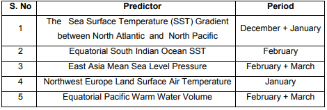
IMD’s SEFS model for the April forecast uses the following 5 predictors that require data upto March.

imd Monsoon forecast

2. Forecast for the 2019 Southwest monsoon Season (June – September) rainfall over the country as a whole

2a. Forecast based on the Monsoon Mission CFS Model

For generating the forecast for the 2019 southwest Monsoon season rainfall, global atmospheric and oceanic initial conditions up to March 2019 were used involving 47 ensemble members.

The forecast based on the CFS model suggests that the monsoon rainfall during the 2019 monsoon season (June to September) averaged over the country as a whole is likely to be 94% ± 5% of the Long Period Average (LPA).

2b. Forecast based on the Operational SEFS

(a) Quantitatively, the monsoon seasonal rainfall is likely to be 96% of the Long Period Average (LPA) with a model error of ± 5%.

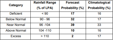
(b) The 5 category probability forecasts for the Seasonal (June to September) rainfall over the country as a whole is given below:

iMAGE 2

Forecast suggests that the 2019 Southwest monsoon rainfall is likely to be near normal. However, there is very less chance for the monsoon rainfall to be above normal or excess.

Overall, the country is expected to have well distributed rainfall scenario during the 2019 monsoon season, which will be beneficial to farmers in the country during the ensuing Kharif season.

3. Sea Surface Temperature (SST) Conditions in the equatorial Pacific & Indian Oceans

At present, weak El Niño conditions (SST anomalies between 0.50 C & 1.00 C) are prevailing over the equatorial Pacific Ocean. The latest forecasts from the Monsoon Mission CFS & other global climate models indicate such conditions are likely to persist during the monsoon season but with reduced intensity in the later part of the monsoon season. It is noted that El Niño predictions made in February/March generally have more uncertainties compared to the El Niño predictions made in June.

At present, neutral IOD conditions are prevailing over the Indian Ocean. The latest forecasts from the models indicate positive IOD conditions development likely during the monsoon season. Positive IOD conditions tend to associate with the normal monsoon over India.

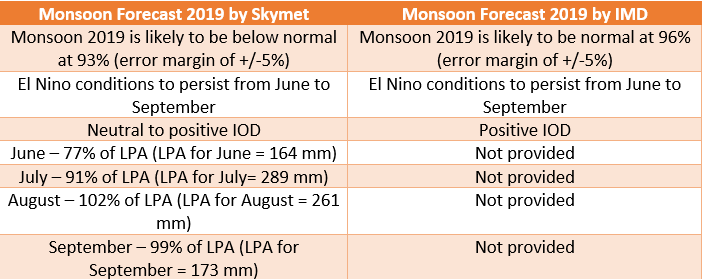
According to Skymet Weather, Monsoon 2019 is likely to be below normal at 93% (with an error margin of +/-5%) of the long period average (LPA) of 887 mm for the four-month period from June to September. 

SKymet and IMD forecast

To download Skymet Weather's Monsoon Forecast report, click here
To download Monsoon 2019 Forecast PPT, click here

Strong winds, rain and dust storm in Lucknow, Kanpur, Agra likely for 48 hrs

Rain and dust storm in Uttar Pradesh

At present, West and East Uttar Pradesh are rain deficient by 58% and 42%, respectively. As per the weathermen, the weather activities are expected to increase over Uttar Pradesh as a Western Disturbance is over Jammu and Kashmir. Its induced Cyclonic Circulation will form over Rajasthan and a trough from this system would go up to West Uttar Pradesh.

Moreover, southeasterly winds from the Bay of Bengal would affect the eastern parts of Uttar Pradesh. Hence, rain and thundershowers with dust storm is possible at many parts of Uttar Pradesh on April 16 and 17. The forecasters say that on April 16, the intensity of rains will be light to moderate over West Uttar Pradesh and light in eastern parts.

Come April 17, few moderate to heavy spells are expected over West and Central Uttar Pradesh. Places like Lucknow, Kanpur, Aligarh, Agra, Hardoi, Mathura, Bulandshahr, Ghaziabad, Hathras, Kasganj and Farrukhabad would get to witness these activities.

Click here to know more about lightning and thunderstorm status in Uttar Pradesh:

Capture

On April 17, hailstorm and dust storm with strong winds would be a sight. There are chances that isolated pockets might get to witness high velocity winds of 60-70 kmph. Looks like, these pre-Monsoon activities have the potential to damage wheat crop that is being harvested at present in many parts of Uttar Pradesh. The harvested as well as ready to harvest crops would suffer due to strong winds and hailstorm activity.

Temperatures are expected to plummet by three to four degrees on April 16 and 17 and can come down in the range of 36°C-40°C. While, weather would clear up by April 18 and the temperatures would once again shoot up.

Image Credit: The Darkroom-Baltimore Sun

Please Note: Any information picked from here must be attributed to skymetweather.com

Dust storm, hailstorm, rain in Punjab, Haryana to damage wheat crops

Rain in Punjab, HaryanaRainfall in Punjab and Haryana will once again make a comeback as a fresh Western Disturbance has induced a Cyclonic Circulation over western parts of Rajasthan. Along with this, a trough is extending from this system up to West Uttar Pradesh.

Thus, rain and thundershowers with isolated dust storm activities are likely to commence over Punjab and Haryana by the evening hours today. Gradual increase in these activities will be seen over these areas.

Also Read: Rain in Delhi and NCR to bring relief from heat

In fact, moderate to heavy rains are likely over many parts on April 16. These activities are expected to continue until tomorrow, i.e. April 17. The weather system will then start moving away eastward and intensity will reduce to quite an extent.

A couple of heavy shower spells, along with violent thunderstorm and dust storm wherein wind speed may reach up to 50 kmph, gusting up to 60 kmph in isolated pockets. Some areas may also see hailstorm activities.

Also Read: Dust storm, rain likely in parts of Rajasthan today

These Pre-Monsoon activities will be damaging to standing crops of wheat. Wheat has been harvested in many parts, but some areas have still not harvested their wheat crops. Thus, these crops will see damage due to strong winds, hailstorm, and rainfall activities.

Read More: Kashmir, Himachal, Uttarakhand to see widespread rains today

Harvested crops which have not been processed yet and are still lying on the fields will also suffer some damage. Temperatures due to these rains will also see a drop, and maximums which have been settling in the higher 30s, will come down to the mid 30s. However, after April 17, maximum temperatures will once again increase.

Image Credit: ndtv

Please Note: Any information picked from here must be attributed to skymetweather.com

[Hindi] आईपीएल 2019: मुंम्बई में सामान्य मौसम के बीच होगा इंडियंस और रॉयल चैलेंजर्स का मैच

आईपीएल के 12वें सीज़न का 31वां मैच मुक़ाबला आज रात 08:00 बजे से मुंबई इंडियंस और रॉयल चैलेंजर्स बंगलौर के बीच मुंबई के वानखेड़े स्टडियम में होगा। इस सीजन में अब तक सिर्फ 1 मैच में जीत दर्ज करने वाली विराट कोहली की रॉयल चैलेंजेर्स बैंगलोर, लीग में बने रहने के इरादे से आज मैदान पर उतरेगी।

मैच के समय मुंबई के मौसम का हाल:

स्काइमेट के मौसम विशेषज्ञों के अनुसार, आज मुंबई में होने वाले आईपीएल के 31वें मुक़ाबले से पहले मुंबई के कुछ इलाकों में गरज के साथ हल्की बारिश देखने को मिल सकती है। हालांकि मैच की शुरुआत तक बारिश बंद हो सकती है। हालांकि आसमान में हल्के बादल छाए रहने और मौसम सामान्य बने रहने की उम्मीद है।

मैच के समय अनुमान है कि मुंबई में 10-15 किमी प्रतिघंटे की रफ्तार से हवा चलेगी। मैच रात में 8 बजे शुरू होगा और उस समय तक मायानगरी मुंबई का तापमान घटकर 27-28 डिग्री के आसपास पहुँच जाएगा। तापमान भी बहुत ज़्यादा नहीं होगा और हवा भी चलेगी जिससे खिलाडियों और दर्शकों को राहत मिलेगी

आंकड़ों पर एक नज़र :

आईपीएल का 12वां सीज़न विराट कोहली की टीम के लिए कुछ खास अच्छा नहीं साबित हुआ है। इस सीजन में रॉयल चैलेंजर्स ने 7 मैचों में सिर्फ 1 मैच में जीत दर्ज की है। पॉइंट टेबल में आरसीबी सबसे अंतिम स्थान पर है। वहीं मुंबई इंडियंस 7 मैचों में से 4 मैच जीत कर चौथे स्थान पर बनी हुई है। इस सीज़न में इन दोनों टीमों का आपस में मुक़ाबला एक बार पहले भी हो चुका है। जिसमें मुंबई ने बैंगलुरु को 2 विकेट से हराया था।

बात अगर आईपीएल के इतिहास में दोनों टीमों के कुल खेले गए मैचों की करें तो 26 मैच में से 17 में मुंबई इंडियंस ने जीत दर्ज की है वहीं रॉयल चैलेंजर्स को 9 मैचों में ही सफलता मिली है। इन आंकड़ों के मुताबिक आज भी मुंबई का पलड़ा भारी दिख रहा है। लेकिन लगातार हार के बाद पिछले मैच में जीत दर्ज करने से बैंगलुरु के खिलाडियों का मनोबल काफी ऊपर है।

ऐसे में आज के मैच के रोमांचक होने की पूरी संभावना है। देखना दिलचस्प होगा कि बंगलुरु की टीम इस सीजन की अपनी दूसरी जीत दर्ज करके मुंबई इंडियंस से बदला ले पाती है या फिर मुंबई के खिलाडी पुराने आंकड़ों में दुगने का अंतर बनाने में कामयाब हो पाते हैं।

बात पिछले मैचों की :

आईपीएल में कल, 14 अप्रैल को 2 मैच खेले गए। पहला मैच कोलकाता और चेन्नई के बीच शाम 4 बजे से खेला गया। जिसमें कोलकाता की टीम ने 8 विकेट खोकर 161 रन बनाये। लक्ष्य का पीछा करते हुए चेन्नई ने 2 गेंद पहले ही 162 रन बना कर मैच अपने नाम कर लिया।

वहीं डेल्ही कैपिटल्स और सनराइज़र्स हैदराबाद के बीच खेले गए दूसरे मुक़ाबले में पहले बल्लेबाजी करते हुए डेल्ही कैपिटल्स ने 7 विकेट खोकर 155 रन बनाये। दूसरी पारी में डेल्ही कैपिटल्स के गेंदबाजों के बेहतरीन प्रदर्शन के सामने हैदराबाद की पूरी टीम लक्ष्य का पीछा करते हुए महज़ 116 रनों पर ढेर हो गयी।

Image Credit: Samachar Nama

कृपया ध्यान दें: स्काइमेट की वेबसाइट पर उपलब्ध किसी भी सूचना या लेख को प्रसारित या प्रकाशित करने पर साभार: skymetweather.com अवश्य लिखें।

IPL 2019: Mumbai Rains to not affect clash between MI v RCB

MI v RCBThe Indian Premier League has displayed a crackling performance this time with several teams playing extremely well. Tonight, Mumbai Indians are all set to lock horns with the Royal Challengers Bangalore at their home ground, Wankhede Stadium in Mumbai, at 8:00 PM.

Weather wise, some thunderstorm and rains have been anticipated for the city of Mumbai. However, these activities will take place during the late evening hours and by the time the match begins, the activity will subside. Temperatures will settle between 30 and 31 degrees Celsius, humidity will be between 70 and 75 percent which may cause slight discomfort to the players.

Talking about the teams, Mumbai Indians stand fourth at the points table after losing to Rajasthan Royals on Saturday. They have four wins out of the seven games played. On the other hand, Royal Challengers Bangalore stand right at the bottom despite winning their first games against the Kings XI Punjab.

Also Read: Long Wait for Mumbai Rains to come to an end today, lightning strikes, squalls likely

It will be interesting to see whether Royal Challengers Bangalore will be able to register a second win or will the Mumbai Indians take that chance away from them.

Mentioning yesterday’s match, in the first phase, Chennai Super Kings throttled the Kolkata Knight Riders maintaining their first spot while Delhi Capitals won against the Sunrisers Hyderabad making their way into the second spot.

Image Credit:

[Hindi] श्रीनगर, शिमला, मनाली, देहरादून सहित कश्मीर, हिमाचल और उत्तराखंड में अच्छी बारिश के आसार

Rain in Dharmshala and Himachal--TribuneIndia 600उत्तर भारत के पर्वतीय राज्यों में पिछले 24 घंटों से मौसम शुष्क बना हुआ है। हालांकि इस दौरान जम्मू कश्मीर में एक-दो स्थानों पर हल्की बारिश की गतिविधियां देखने को मिलीं। दूसरी तरफ हिमाचल प्रदेश और उत्तराखंड में बादल छाए रहे लेकिन मौसम अब बारिश के लिए फिर से अनुकूल बन रहा है।

मौसम विशेषज्ञों के अनुसार उत्तरी पाकिस्तान और इस सटे भागों पर एक पश्चिमी विक्षोभ पहुंचा है। इस सिस्टम के प्रभाव से राजस्थान पर एक चक्रवाती हवाओं का क्षेत्र विकसित हुआ है। अनुमान है कि आज जम्मू कश्मीर में बारिश शुरू हो जाएगी। धीरे-धीरे बाकी पर्वतीय राज्यों पर भी मौसम बदलेगा और हिमाचल प्रदेश तथा उत्तराखंड में भी बारिश देखने को मिलेगी।

मौसम विशेषज्ञों के अनुसार 16 और 17 अप्रैल को जम्मू कश्मीर, हिमाचल प्रदेश और उत्तराखंड में अधिकांश स्थानों पर बादलों की गर्जना के साथ बारिश की संभावना है। तीनों पहाड़ी राज्यों में कहीं-कहीं भारी वर्षा के भी आसार हैं। जम्मू कश्मीर और हिमाचल प्रदेश की ऊंचाई वाले स्थानों पर बर्फबारी भी हो सकती है।

इस बीच पर्वतीय राज्य में ज्यादातर जगहों पर वर्षा होने की संभावना के बीच हमारा सुझाव है कि पहाड़ों पर पर्यटन के लिए अगले दो-तीन दिन जाने से बचें क्योंकि तेज बारिश के कारण भूस्खलन या अन्य कारणों से रास्ते बंद होने का खतरा है। जिससे जगह-जगह जाम लग सकता है और अपने बच्चों और परिजनों के साथ कहीं रास्ते में फंस सकते हैं।

जम्मू कश्मीर में मौसम चेतावनी: मौसम विशेषज्ञों के अनुसारबनिहाल, जम्मू, कटरा, गुलमर्ग, पहलगाम, काजीगुंड, श्रीनगर सहित राज्य के कई शहरों में अगले दो-तीन दिनों के दौरान मौसम बदला हुआ दिखाई देगा। वैष्णो देवी में भी बारिश होगी।

हिमाचल में मौसम चेतावनी: हिमाचल मेंबिलासपुर, चंबा, हमीरपुर, कांगड़ा, किन्नौर, कुल्लू, लाहौल स्पीति, मंडी, शिमला, सिरमौर, सोलन, धर्मशाला और ऊना में होगी अच्छी बारिश।

उत्तराखंड में मौसम चेतावनी: अल्मोड़ा, बागेश्वर, चमोली, चंपावत, देहरादून, गढ़वाल, हरिद्वार, नैनीताल, पिथौरागढ़, रुद्रप्रयाग, टिहरी गढ़वाल, उधमसिंह नगर और उत्तरकाशी सहित ज़्यादातर शहरों में वर्षा की उम्मीद है।

Image credit: Tribune India

कृपया ध्यान दें: स्काइमेट की वेबसाइट पर उपलब्ध किसी भी सूचना या लेख को प्रसारित या प्रकाशित करने पर साभार: skymetweather.com अवश्य लिखें।

Rains with strong winds and lightning to lash Kolkata, Jamshedpur, Ranchi and Patna this week

Rain in Kolkata

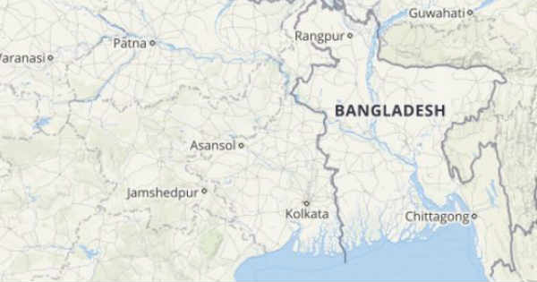
Slowly and steadily another spell of pre-Monsoon rains are coming back towards East India. In last two days, activity has been on a lower side and was witnessed in isolated pockets only. Places like Bankura, Malda, Berhampore in Gangetic West Bengal and Ranchi and Jamshedpur in Jharkhand, and Purnia and Supaul in Bihar have witnessed isolated weather activities over a period of last two days.

As per the weather experts, similar pattern of isolated rains would be a sight today as well. While, April 16 onward, these isolated activities would eventually turn into moderate activities. Adding to this, all the three states of Bihar, Jharkhand and Gangetic West Bengal would witness activities simultaneously on April 18 and 19. During this time, one can expect high velocity winds, lightning strikes with thunder squalls.

These activities are being witnessed in wake of a Cyclonic Circulation over East Uttar Pradesh and Bihar. Along with this, an Anti-Cyclone in the Bay of Bengal is feeding moisture to these states. There will be rain and thundershower activities over Northwest Plains on April 16 and 17. This weather system on traveling East would also act as a catalyst, thus resulting in good rain and thundershowers on April 18 and 19.

Kolkata, Shantiniketan, Malda, Diamond Harbour, Jamshedpur, Ranchi, Bokaro, Patna and Gaya would be on a receiving end of these rains during this time.

Click here to check live lightning and thunderstorm across Bihar, Jharkhand and Gangetic West Bengal:

k

The trio states have so far witnessed mild summers because of intermittent rain and thundershower activities. As of now, Bihar, Jharkhand and Gangetic West Bengal are in large rainfall excess. However, in the absence of these weather activities, temperatures soared in last two days. Yesterday Gaya in Bihar recorded season’s highest at 42.1°C. Similarly, Jamshedpur and Daltonganj also recorded season’s highest so far at 40.4°C and 43.3°C, respectively.

The relief from high temperatures will be a sight on April 18 and 19 when simultaneous weather activities would be a sight. During this time, more of thunderstorm with strong winds of 50-60 kmph and lightning strikes will be seen.

Image Credit: Telegraph India

Please Note: Any information picked from here must be attributed to skymetweather.com

[Hindi] राजस्थान व गुजरात में अगले दो-तीन दिन आँधी-तूफान के साथ बारिश का मौसम

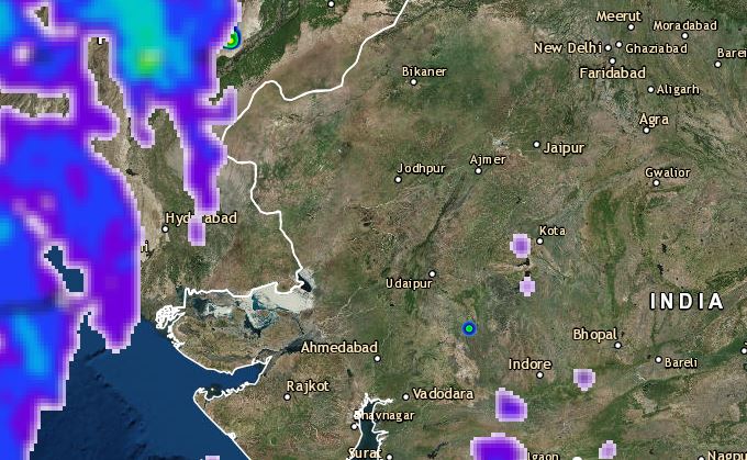
राजस्थान और गुजरात में पड़ रही भीषण गर्मी से कुछ निज़ात मिलने के संकेत मिल रहे हैं। इस समय उत्तरी पाकिस्तान और इससे सटे जम्मू-कश्मीर के ऊपर एक नया पश्चिमी विक्षोभ बना हुआ है। इसके प्रभाव से दक्षिण-पश्चिमी राजस्थान पर एक चक्रवाती हवाओं का क्षेत्र विकसित हुआ है। इसके कारण राजस्थान और गुजरात के हिस्सों में आज से धूलभरी आंधी और गरज के साथ बारिश की गतिविधियां देखने को मिल सकती हैं।

मौसम विशेषज्ञों के अनुसार आने वाले 24 घंटों में राजस्थान से गुजरात और महाराष्ट्र होते हुए उत्तरी कर्नाटक तक एक ट्रफ रेखा भी बन सकती है। जिससे गुजरात और राजस्थान के अधिकांश इलाकों में गरज के साथ बारिश की गतिविधियां प्रभावी रूप से देखने को मिल सकती हैं।

Also Read In English: Dust storm, rain in Jaipur, Jodhpur, Jaisalmer, Surat, Ahmedabad from today, relief from heat

देखते हैं कि अगले दो-तीन दिनों के दौरान गुजरात और राजस्थान के कौन-कौन से शहरों में होगी बारिश और चलेंगी धूलभरी आँधी:

राजस्थान : राजस्थान में 15 से 17 अप्रैल तक अजमेर, अलवर, बांसवाड़ा, बारां, बाड़मेर, भरतपुर, भीलवाड़ा, बीकानेर, बूंदी, चित्तौड़गढ़, चुरू, दौसा, धौलपुर, डूंगरपुर, गंगानगर, हनुमानगढ़, जयपुर, जैसलमेर, जालौर, झालावाड़, झुंझुनू, जोधपुर, करौली, कोटा, कोटा, कोटा पाली, प्रतापगढ़, राजसमंद के साथ-साथ सवाई माधोपुर, सीकर, सिरोही, टोंक और उदयपुर सहित राज्य के कई शहरों में धूलभरी आंधी के साथ बारिश होने की संभावना है। कुछ स्थानों पर 50 से 70 किमी प्रति घंटे की रफ्तार से तेज़ हवाएँ भी चल सकती हैं।

गुजरात : इसी तरह गुजरात मेंअहमदाबाद, अमरेली, आनंद, अरावली, बनासकांठा, भरूच, भावनगर, बोटाड, छोटा उदयपुर, द्वारका, दोहद, गांधीनगर, जामनगर, कच्छ, खेड़ा, मेहसाणा, महिसागर, मारवी, नर्मदा, नवसारी, पंच महल, राजकोट, सबरकांठा, सूरत, सुरेंद्रनगर, तापी, वड़ोदरा और वलसाड सहित अधिकांश शहरों में 15 और 16 अप्रैल को तेज़ हवाओं और गरज के साथ बारिश होने की संभावना है।

मौसम विशेषज्ञों के अनुसार, यह मौसमी गतिविधियां इन इलाकों में 17 अप्रैल तक प्रभावी रह सकती हैं। इसके बाद मौसमी सिस्टम के कमजोर होने के साथ ही बारिश में कमी आने का अनुमान है। जबकि राजस्थान के उत्तरी और उत्तर-पूर्वी भागों में एक-दो स्थानों पर धूलभरी आंधी और गरज के साथ बारिश की गतिविधियां जारी रह सकती हैं।

इन दोनों राज्यों में तेज़ गर्मी पड़ रही है। कई इलाके लू जैसे हालात का सामना कर रहे हैं। अगले दो-तीन दिनों के दौरान संभावित बारिश से तापमान में 3-4 डिग्री की गिरावट होने की संभावना है जिससे तेज़ गर्मी से राहत मिलने की उम्मीद है। हालांकि यह गतिविधियां शाम के समय होंगी इसलिए दोपहर तक तेज़ गर्मी जारी रहेगी।

अपने क्षेत्र में गरज वाले बादलों की ताज़ा स्थिति जानने के लिए नीचे दिए गए मैप पर क्लिक करें: 

Rajasthan and Gujarat Lightning

Image Credit: msn.com

कृपया ध्यान दें: स्काइमेट की वेबसाइट पर उपलब्ध किसी भी सूचना या लेख को प्रसारित या प्रकाशित करने पर साभार: skymetweather.com अवश्य लिखें।


Wait for Mumbai rains to end today, squally winds and lightning strikes to accompany

Rain in Mumbai

Mumbai rains have been a much awaited event, especially during this time of the year when the city is battling extreme hot and sultry weather conditions. Skymet Weather has already been predicting rain in Mumbai during the next 48 hours. During last 24 hours also, isolated parts of Mumbai and suburbs have received scattered rain and thundershower activities.

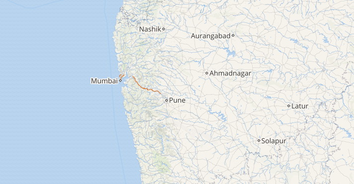
Weather conditions remain favourable for some more pre-Monsoon rains in Mumbai. A cyclonic Circulation is marked over West Rajasthan and a trough is extending from this circulation to South Madhya Maharashtra across Gujarat region. Due to these weather systems, it is expected that rains might pick up pace in Maharashtra and Mumbai might also receive scattered light to moderate rain and thundershower activities on April 15-16. These activities can be accompanied with squally winds and lightning strikes as well.

Live lightning and thunderstorm status across IndiaClick here to check the live lightning, rain and thunderstorm status across Mumbai

One or two intense spells might also be a sight. It is foreseen that this could be the first good spell in Mumbai in the month of April. This would also mark the commencement of the pre-Monsoon season in Mumbai.

April is one of the driest months for Mumbai with monthly average of only 0.1 mm. Mumbai has not received any rain in the month of April in last 10 years except on two occasions. One was on April 30, 2010 wherein Mumbai recorded 0.7 mm of rains and other on April 15, 2015 which just saw traces of rain.

Also read: Performance of Mumbai Monsoon during El Nino years, how will 2019 be 

However, apart from Mumbai, other parts of Maharashtra would witness rain and thundershowers with much more intensity.

Between November and April, monthly rain average for Mumbai is in single digit, wherein March is considered to be the driest month with no rainfall. Whereas, January to April’s monthly average is less than one mm. Unlike in rest of the country, pre-Monsoon activities  are a rare sight in Mumbai. In fact, May also does not see any significant pre-Monsoon rains.

These pre-Monsoon activities only pick up pace just before the arrival of Monsoon in Mumbai, which usually happens to be around June 10.  The significant increase in rain activities are witnessed during Monsoon between June and September. During Monsoon, July is the rainiest month with monthly average of 840.7 mm.

Image Credit: Firstpost

Please Note: Any information picked from here must be attributed to skymetweather.com

Performance of Mumbai Monsoon during El Nino years, how will 2019 be

Mumbai Rains

Mumbai is one of the rainiest locations in India during Southwest Monsoon season. In fact, 94 percent of annual rain for Mumbai occurs during this time while the time between December to April remains practically dry.

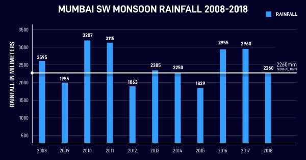
Mumbai sees more than 70 rainy days between June and September. Meanwhile, June and July see rains almost daily. The seasonal rain for Mumbai is 2260 mm with July being the rainiest month 841.1 mm.

Also Read: El Nino Arrives, Monsoon 2019 to face the heat

Mumbai has the precedence to exceed its normal in all four months, which happened in 2017 when total rains occurred was at 2960 mm. During this time, the city saw 300 mm in 24 hours twice.

Take a look at the Monsoon performance during the last decade for Mumbai

Mumbai Rains

If rain amounts are to be seen between 2008 to 2018, the best performer has been 2010 with total rains at 3207 mm. While some months see lesser rains than the other, Southwest Monsoon has never failed in all the four months.

Even during the El Niño years, Mumbai has seen less rains for three months i.e. in 2009 and 2015. However, 2009 July was the saving grace, wherein the rain received was at 1120 mm. During a very few months, four-digit rains are seen. 2009 saw three occasions, where three-digit rains were seen in 24 hours.

For the El Niño years, 2015, June was the saving grace with rains being at 1111.6 mm during this time and thrice did the city record three-digit rains in a span of 24 hours.

For El Niño 2009 year, the month of June was the poorest, while for El Niño 2015 June was the rainiest.

The months of June and July are the favourites for three-digit rains in 24 hours. At times, onset is also preceded by three-digit rainfall.

The year 2019 has also seen El Niño finally marking its arrival however, this is a devolving El Niño year due to which we may face shortfalls of rains, but nothing to panic about. On the other hand, 2009 and 2015 were growing El Niño years due to which some months performed really poorly.

Image Credit: Instagram

Also Read: Wait for Mumbai rains to end today, squally winds and lightning strikes to accompany 

Please Note: Any information picked from here must be attributed to skymetweather.com


latest news