Skymet weather

Weather Forecast April 20: Rain in Kerala, Tamil Nadu, Karnataka, Telangana and AP, North India to remain dry

To begin with South India, a trough is extending from South Chhattisgarh to Interior Tamil Nadu across Telangana and Andhra Pradesh. Due to this, scattered rains are possible in parts of Kerala and Tamil Nadu during the next 24 hours. South Interior Karnataka including Bengaluru, Telangana and Andhra Pradesh will also witness isolated rains.

Moving to central parts, the region will start heating up once again and day temperatures in parts of Rajasthan, Gujarat, Madhya Pradesh and Vidarbha may even reach up to 40˚C.

Similarly, in the absence of any weather system over North India, dry and hot winds from northwest direction are blowing over the region. Therefore, weather in Jammu and Kashmir, Himachal Pradesh and Uttarakhand will remain dry. However, one or two short spells of rain cannot be ruled over Kashmir.

Meanwhile, day temperatures of Punjab, Haryana, Delhi, North Rajasthan and West Uttar Pradesh will see further increase, leading to very warm weather.

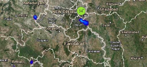
Click the image below to see the live lightning and thunderstorm across IndiaRain in India
The rainfall activities will also witness significant decrease over the eastern and northeastern parts of the country. However, light rains may continue in parts of Assam, Meghalaya and Arunachal Pradesh. Parts of Odisha will also observe light rains. However, weather of East Uttar Pradesh, Bihar, Jharkhand and West Bengal will become dry and very warm.

Any information taken from here should be credited to skymetweather.com


Day Temp in Delhi, Punjab, Haryana, UP and Rajasthan likely to touch 40 degrees

Summers in Delhi

The northwestern plain of the country has been the centre of weather activity for the last few days in terms of rain and dust storm. A Western Disturbance in the northern hills along with an induced Cyclonic Circulation has been the reason behind some good activity in the region.

Now, both these systems have moved away and become insignificant . The pre-Monsoon rain and thundershower activities that happened on April 15, 16 and 17 have now subsided. According to meteorologists at Skymet, the weather in the northwestern part of the country including the national capital Delhi  and its adjoining areas like Noida and Gurugram would now become dry with temperatures expected to rise gradually.

The easterlies have changed their direction to westerlies/northwesterlies, these dry and hot winds will lead to rise in mercury levels. However, the temperatures are presently below normal at many places. For instance, on April 19, Amritsar recorded a maximum of 31.6°C which was three degrees below normal. While, Delhi’s Safdarjung Observatory recorded 32.6° as maximum on the same day, which was four degrees below normal. Whereas, in Chandigarh both the day and night temperatures settled at 32.6°C and 19.8°C, respectively, which were about two to four degrees below normal.

Though, temperatures are now expected to rise due to clear skies, heat wave conditions will not be observed in the region for at least  3-4 days.

Delhi and its adjoining areas may however see a significant rise in temperatures in the next two days.The day temperature could touch 39°C in the city. Similar weather conditions are expected in Uttar Pradesh as well.

Image Credit: DNA India

Please Note: Any information picked from here must be attributed to skymetweather.com

Heat wave like conditions in many parts of Maharashtra and Vidarbha

maharashtra marathi website

At present, a trough is extending from Chhattisgarh to Interior Tamil Nadu across eastern parts of Vidarbha. In view of this system, we expect isolated rain and thundershower activities in Vidarbha during the next 24 hours. Thereafter, the weather activity in the region will diminish with almost dry conditions prevailing.

After receiving good rains on April 15 and 16, the weather in Maharashtra has mainly been dry. Recent rain and thundershower activities across northern plains and Central India were responsible for the drop in temperatures across Maharashtra in the last few days. This is when the temperatures over most parts of the state were recorded below the 40 degree mark.

After the weather activity has diminished from most parts of Central and North India, there is a gradual rise in temperatures in parts of Vidarbha. Isolated pockets in the region have recorded temperatures touching 40 degrees Celsius due to the commencement of dry and hot Northwesterly winds. The temperatures are now expected to keep rising gradually in the region.

By Monday, April 22, the day temperatures in several parts of Vidarbha may breach the 40 degrees Celsius mark. Isolated pockets of Marathwada as well as North Madhya Maharashtra will observe maximums hovering close to 40 degrees.

Although we do not expect heat wave in Maharashtra anytime soon, the day temperatures are surely showing a rising trend.

Temperatures over Konkan and Goa and South Madhya Maharashtra, however, will remain below normal with comfortable weather conditions.

We also have some good news for Mumbaikars in terms of relief from heat. According to weathermen at Skymet, the day temperature in Mumbai may settle below normal, close to 33°C, for the next couple of days.

Image Credits – Mumbai Times

Any information taken from here should be credited to Skymet Weather

Three days of good rain likely in Northeast India

Northeast Monsoon Tamil Nadu_Livemint 600

During the last 24 to 48 hours, rainfall activity in Northeast India has decreased. However, Assam and Arunachal Pradesh are still receiving intermittent rains. According to weathermen, rain and thundershower activities are likely to increase once again over most parts of the northeastern states in the wake of a Cyclonic Circulation which has developed over Meghalaya and its adjoining areas. Also, the Anti-Cyclone which was over central parts of the Bay of Bengal has now shifted towards North Bay of Bengal. Due to this movement of the weather system, humid winds from the Bay of Bengal are feeding moisture to the northeastern states.

According to meteorologists at Skymet, the combined effect of the Cyclonic Circulation and moisture incursion from the Bay of Bengal is expected to increase rainfall activity in Assam, Meghalaya, Nagaland and Manipur. Mizoram and Tripura may also receive light rain.

This rainfall activity is expected to continue for two to three days. Heavy to very heavy rains are ruled out, but isolated intense spells are in the offing for Northeast India. These rains will be accompanied by lightning strikes and strong surface winds. One or two places may also report hailstorm activities.

Such intermittent rainfall activities are a common feature until the start of the Monsoon season due to the semi-permanent feature of Anti-Cyclones persisting in the Bay of Bengal. These systems keep oscillating from North to South. And whenever, an Anti-Cyclone develops in North Bay of Bengal a Cyclonic Circulation forms over the northeastern states giving rain in the region.

Image Credits – India Today 

Any information taken from here should be credited to Skymet Weather


Odisha to receive rains for the next 3 to 4 days

Odisha Rains 3

At present a Cyclonic Circulation can be seen over eastern parts of Bihar and a Trough is extending from this Cyclonic Circulation up to interior Tamil Nadu while passing through Gangetic West Bengal, Odisha, coastal Andhra Pradesh, South Interior Karnataka. Therefore, we expect moderate rain and thundershower activities over the state of Odisha for next 48 hours.

Although these weather activities will not be very intense, however one or two spells of intense rain and thundershower activities with lightning strikes cannot be ruled out. The intense activity will subside after 48 hours as the weather system will weaken in intensity.

However, light on off rains will continue over Odisha for the next three to four days as this North South trough will prevail in the region as a semi-permanent feature.

These rains will also mean a subsidy from the already peaking temperatures over the state. Yesterday the state capital of Bhubaneswar recorded the maximum temperature of 38.7°C apart from receiving some isolated Pre-Monsoon rains. This temperature was a total of two degree higher than the normal mark. Humidity levels were also recorded at a high yesterday. Now however a slight relief from heat wave conditions is in sight.

Image Credits – Odisha Tourism 

Any information taken from here should be credited to Skymet Weather


महाराष्ट्र में शुष्क और गर्म मौसम से होगी तापमान में वृद्धि, अगले सप्ताह तक हीट वेव की वापसी

Summer-in-Gujarat

16 और 17 अप्रैल को महाराष्ट्र के कई हिस्सोंविशेष रूप से विदर्भउत्तर मध्य महाराष्ट्र और मराठवाड़ा के कुछ हिस्सों में गरज के साथ हल्की से मध्यम बारिश देखी गयी। इन मौसम गतिविधियों के कारणविदर्भ और मराठवाड़ा में तापमान में 6 से 7 डिग्री की गिरावट दर्ज की गयी, जबकि मध्य महाराष्ट्र में 2 से 3डिग्री की गिरावट देखी गई। विदर्भ और मराठवाड़ा में पूर्व मध्य प्रदेश से दक्षिण आंतरिक कर्नाटक तक एक ट्रफ के कारण ये मौसम गतिविधियाँ दर्ज की गयी।

अबयह ट्रफ कमजोर हो गई हैइस प्रकार मौसम की गतिविधियाँ पूर्व की ओर यानि आंध्र प्रदेश और तेलंगाना की ओर स्थानांतरित हो गई हैं। इस प्रकारमहाराष्ट्र के अधिकांश हिस्सों में कोई भी मौसम गतिविधियां नहीं देखी जाएंगी। हालांकिअगले 48 घंटों के दौरान विदर्भ और मराठवाड़ा के कुछ हिस्सों में गरज के साथ हल्की बारिश होने से इंकार नहीं किया जा सकता है।

इस बीचकोंकण और गोवा में मौसम का शुष्क रहने की उम्मीद है। साथ हीउत्तर-पश्चिमी हवाएं राज्य के अधिकांश हिस्सों का रुख करेंगी जो की तापमान में वृद्धि के लिए जिम्मेदार होंगी।

पूरे महाराष्ट्र में तापमान में धीरे-धीरे वृद्धि देखी जाएगी, 22 और 23 अप्रैल तक विदर्भ और मराठवाड़ा और मध्य महाराष्ट्र के कुछ क्षेत्रों में हीट वेव की लहर की स्थिति में वापसी होगी।

Image Credits – India Today

Any information taken from here should be credited to Skymet Weather

पंजाब, हरियाणा, दिल्ली, राजस्थान और उत्तर प्रदेश में लौटा शुष्क मौसम, तापमान में होगी बढ़ोतरी

Heatwave in MP --HindustanTimes 600

पिछले दो तीन दिनों सेपंजाबहरियाणाराजस्थानदिल्ली और पश्चिम उत्तर प्रदेश सहित उत्तर-पश्चिम भारत के कई हिस्सों में धूल भरी आंधीतेज़ हवाओं और बिजली के साथ-साथ गरज के साथ बारिश देखी गयी।

इन मौसमी गतिविधियों से उत्तर-पश्चिमी मैदानी इलाकों के अधिकांश हिस्सों में दिन के तापमान में 10 से12 डिग्री तक की गिरावट दर्ज की गयी। वास्तव मेंएक दो जगहों में 14 से 15 डिग्री की गिरावट देखी गई।

अब मौसम प्रणालियां जो इन मौसम गतिविधियों के लिए जिम्मेदार थींयानी जम्मू और कश्मीर पर बना पश्चिमी विक्षोभ और राजस्थान पर इससे प्रेरित हवाओं का चक्रवात अब पूर्व की ओर चले गए हैं।

इसके साथ ही, गरम और शुष्क उत्तर-पश्चिमी हवाओं ने एक बार फिर मैदानी इलाकों में वापसी कर ली है।इसलिएआज हम पंजाबहरियाणादिल्लीराजस्थान और पश्चिम उत्तर प्रदेश में तापमान बढ़ने की उम्मीद करते हैं। तापमान में धीरे-धीरे वृद्धि होगीइसलिए दिल्लीहरियाणा और राजस्थान के कुछ हिस्सों में लू जल्द वापसी नहीं करेगी।

आने वाले 2 से 3 दिनों में उत्तर पश्चिम भारत में शुष्क मौसम जारी है और अप्रैल 20 या 21 के आसपास हीट वेव लौट सकती है। 19 अप्रैल तकअधिकतम तापमान उत्तर पश्चिमी भारत के अधिकांश हिस्सों में 30से अधिक हो जाएंगे।

Image Credits – Navbharat Times

Any information taken from here should be credited to Skymet Weather

IPL 2019: Humid Kolkata to host KKR v RCB match

KKR v RCB

The Indian Premier League continues to be as engaging as it was in the beginning. Chennai Super Kings continue to be at the top while Royal Challengers Bangalore are still at the bottom of the points table. Tonight Kolkata Knight Riders will lock horns with the Royal Challengers Bangalore at the Eden Gardens in Kolkata at 8:00 p.m.

Talking about the weather conditions in Kolkata, chances of rainfall in the City are not as likely as it seems. However, sky conditions will remain cloudy which temperature settling between 27 and 29 degrees. While the weather will be comfortable, humidity which will be high may cause some discomfort.

Talking about both these teams, Kolkata Knight Riders are at the sixth spot with eight points in hand while the Royal Challengers Bangalore continue to be at the bottom most spot with just one win in hand out of eight games played. It will be interesting to see who ends up winning in this battle tonight and reaches a little closer to what is a ticket to the playoffs.

Talking about last night’s game, Mumbai Indians throttled the Delhi Capitals with a convincing win of 40 runs sending themselves up in the points table.

Pre-Monsoon rains to intensify over Kerala, Tamil Nadu, dry spell to end in Chennai too

Rain in Tamil Nadu and Kerala

Although late but pre-Monsoon rains and thundershowers have finally picked up pace in southern parts of the country. According to Skymet Weather, a trough extending from this East Bihar to interior parts of Tamil Nadu across Gangetic West Bengal, Odisha, Coastal Andhra Pradesh, Telangana and South Interior Karnataka would be helpful in giving more rains over Tamil Nadu, Kerala and parts of South Interior Karnataka.

The experts have to say that this trough is semi-permanent feature during the pre-Monsoon season that keeps oscillating east and west, at times over Kerala and at times pass through interior Tamil Nadu. Thus, South Interior Karnataka including Bengaluru is all set to witness intermittent rain and thundershower activities.

Kerala has already been receiving pre-Monsoon rain and thundershowers since last many days. These rains are expected to continue for the coming days as well. The intensity would be much more in Kerala and interior Tamil Nadu. However, coastal parts of Tamil Nadu might also witness on and off rain activities.

Chennai which has been experiencing dry weather for last many days would now get to witness these isolated pre-Monsoon showers during next two to three days. Still it is believed that rains would remain confined to interior parts of Tamil Nadu and Kerala only.

Coimbatore and Kochi have already witnessed good rains. In the past 24 hours, Thiruvanathapuram in Kerala has recorded around 33 mm of rains. While, Cochin saw nearly 38 mm of rains with high humidity levels over the same. Kozhikode and Coimbatore both recorded 19 mm of pre-Monsoon rains.

Thunderstorm accompanied with gusty winds wherein wind speed reaching 30-50 kmph and lightning at isolated places are very likely over Tamil Nadu and Kerala.

Along the trough, wind discontinuity or confluence zone is also expected to develop over interior parts of Tamil Nadu and Kerala leading to moisture incursion from Bay of Bengal and Arabian Sea. Thus, resulting in further continuation of rain and thundershowers over these two states for the coming three to four days.

Also Read: Pre Monsoon rains to pick up pace in Hyderabad, Telangana, Andhra Pradesh in 24 hours 

Image Credit: The Weather Channel

Any information taken from here should be credited to Skymet Weather

Hyderabad to continue receiving rains, relief from heat wave in sight

hyderabad-during-monsoons

Hyderabad has received heavy rain and thundershower activities yesterday that comprised of a few moderate spells associated with strong gusty winds. The Hyderabad Airport recorded 20.1 mm of rain in the last 24 hours.

The reason- a trough which is extending from Jharkhand to interior Tamil Nadu across Odisha, South Tamil Nadu, Chhattisgarh and Telangana. Due to this, Pre-Monsoon weather activities are taking place over the city. These activities take place particularly during late evening hours as whenever temperatures increase and moisture is readily available, this is when the rain activities occur.

Now, Southwesterly winds from Bay of Bengal are meeting with dry and hot Northwesterly winds over Telangana, leading to development of convective clouds.

These on and off rain activities are expected to continue for the next 24 to 48 hours. Strong winds are also likely to blow over the region.

Today temperatures are expected to be recorded somewhere around 38 to 40 degrees in the city. In the next 24 hours, temperatures are expected to drop marginally, however. This will mean a relief from the prevailing heat wave conditions. Humidity on the other hand will continue keep soaring.

Thereafter, this trough will oscillate slightly towards East over coastal Andhra Pradesh and Rayalaseema. Therefore, these weather activities will recede thereafter.

However, this Trough is a semi-permanent feature during this time of the year. So, the weather will not go completely dry over Telangana as well as Hyderabad. With short breaks it will resume, and pre-monsoon activities may continue thereafter also.

Image Credits – Indian Eagle 

Any information taken from here should be credited to Skymet Weather


Pre Monsoon rains to pick up pace in Hyderabad, Telangana, Andhra Pradesh in 24 hours

Pre Monsoon Rain in Telangana and Andhra Pradesh

Andhra Pradesh and Telangana have been witnessing pre-Monsoon rain and thundershowers of varying intensity in the wake of several weather systems prevailing near the region. One is the Cyclonic Circulation over eastern parts of Bihar. From this system a trough is seen extending to interior parts of Tamil Nadu across Coastal Andhra Pradesh, Telangana and South Interior Karnataka.

Hence, the rain activities, which have occurred over Odisha, Andhra Pradesh, South Interior Karnataka and Tamil Nadu, will continue for coming three to four days. This north-south trough is a semi- permanent feature, which keeps oscillating east and west. Now, this trough is expected to shift its base to east over Andhra Pradesh, therefore intensity of rains might go up in Coastal Andhra Pradesh as well as in Rayalaseema. We also expect intermittent rain and thundershower activities to continue across many parts of Telangana.

These being the pre-Monsoon activities, therefore thunderclouds would start developing towards afternoon and intensity is expected to increase during that time period.

Telangana, so far, has witnessed good rain and thundershower activities. Hyderabad has also received good rains  in past 24 hours and recorded around 20.1 mm of rains.

Similar weather activities are expected in pockets of Telangana as well. During pre-Monsoon, rain and thundershowers are witnessed in patches and are not fairly widespread in nature. Thus, now few districts of Telangana might see good rains coupled with intense thundershowers towards afternoon and evening.

Temperatures are expected to remain below normal at many places of Telangana. Andhra Pradesh too has been witnessing intermittent rain and thundershowers from the last few days. On April 18, Anantapur  in Andhra Pradesh recorded 33.2 mm of rains and also the minimums dropped and settled at 19.6 degrees, which is six degrees below normal. Similarly, Hyderabad and Hanamkonda  in Telangana recorded 20.1 mm and 23 mm of rains respectively in past 24 hours. The minimums over these regions too have fallen by a couple of degrees.

Also Read: Andhra Pradesh and Telangana to witness Pre-Monsoon rains with increased intensity

Image Credit: DNA India

Any information taken from here should be credited to Skymet Weather


Heat wave to make a comeback in Punjab and Haryana in the next two days

image_750x_5b09004cc4e29

The last week was a one filled with lots of weather activities for the duo states of Punjab and Haryana- be it the reoccurring dust storms, on and off rains or the thundershowers with intense lightning and strong winds. The residents however, seemed to enjoy the weather as it brought along a relief from otherwise peaking temperatures. Day temperatures dropped by a whopping 10 to 12 degrees in most parts. A few places even recorded a 14 to 15 degree drop.

Talking meteorologically, the reason for this weather was a strong Western Disturbance over the hills in the influence of which a Cyclonic Circulation had formed back at Plains. Now both these systems however have moved away eastwards. A much weaker system has replaced the Western Disturbance in Jammu and Kashmir.

Absence of weather activities has already led to a rise in day temperatures in the last 24 hours over Punjab and Haryana. Since, temperatures are set to rise gradually, heat wave conditions are being ruled out as of now for at least next few days. However, heat wave may make a comeback around April 20 or 21. Today, the day temperatures are likely to be recorded in higher 30s over most parts of the state.

As of now, dry weather will prevail over the regions at least in the coming next two days.

Image Credits – Pollywoods 

Any information taken from here should be credited to Skymet Weather


latest news