Skymet weather

Bengaluru observes Zero Shadow Day today

Zero Shadow DayBengaluru observed the Zero Shadow Day wherein the Jawaharlal Nehru Planetarium was all decorated for students along with the astronomy enthusiasts. On this day, the sun was at the zenith of Bengaluru, due to which it did not cast a shadow at 12:18 pm, hence the name ‘Zero Shadow Day’.

This phenomenon is seen twice a year. The first time it occurs is when the sun moves towards the northernmost point of the Tropic of Cancer, which is known as the Summer Solstice. On its way to the Tropic of Cancer, the sun passes directly over Bengaluru which was today.

On the other hand, the sun retraces towards the southern point, and on its way, the shadow is once again seen in Bengaluru the second time. The Jawaharlal Nehru Planetarium had also organized a workshop between 10:30 am and 3:30 pm.

Apart from Bengaluru, the Zero Shadow Day was also observed in other cities including Chennai, New Delhi, Mangaluru, and Jaipur. However, the timings did vary in each of these cities. Generally, the sun is slightly away around the noon time towards the north or south. However, on Zero Shadow Day, the sun is seen to be exactly overhead.

Image Credit:

El Nino looms large, Monsoon 2019 to remain under shadow

Monsoon in India

Over the past week, no changes were noticed in the El Niño conditions as equatorial sea surface temperatures (SST) continued to be above average across most of the Pacific Ocean. There was a slight variation since the last week in Nino 3.4 region, while others maintained their status.

El Nino temperaturesAccording to Skymet Weather, although there has been marginal drop in Nino 3.4 region, but it is still well above the threshold value of 0.5°C. Also, marginal variation in the weekly values is considered to be absolutely normal.

However, current Oceanic Niño Index (ONI), which is three months running mean of SST anomaly in the Niño 3.4 region, for JFM (January – March) continues to be at 0.8°C. In fact, the following episodes of FMA (February-April) and MAM (March-May) are most likely to follow the same route.

Also, sub-SSTs anomalies have also been meandering for the last six-seven months. We saw a peak in temperatures during October, which dipped to minimum in December. SSTs again gained momentum and we saw them rising and crossing threshold values in January and February. And now, again we are seeing a slight dip.

As per weathermen, there are several factors which are responsible for the variations in temperatures, which makes it a normal process.

1) Ocean currents are a dynamic medium and keep changing from time to time

2) Air pressure and wind pattern is another vital factor to affect SSTs, is also constantly in accordance with El Niño

3) Passage of MJO (Madden–Julian oscillation) always bring some change in the temperatures, which are temporary in nature. Its leading phase would bring warm waters, while its trail phase leaves cold waters. MJO has recently passed through Pacific and can be one of the prime reasons behind the drop in temperatures.

Monsoon 2019 to face the heat

We are inching closer to Monsoon 2019, but Pacific continues to be warmer all across. As reiterated earlier, this would have great bearing on the upcoming Southwest Monsoon 2019, particularly the onset of month of June would see the worst impact.

As per the Skymet Weather’s forecast for Monsoon 2019, June is likely to see drought like conditions with rains to the tune of 77%. But as we expect 2019 to be a devolving El Niño year, the situation will improve to extent in July with 91% of rains but would still remain below normal.

The only hope would be August which is likely to see normal rains to the tune of 102%. Similar pattern would be followed in September with 99% of rains. However, this would not be solely because of the devolving El Niño but the likely passage of MJO though Indian Ocean. Also, Indian Ocean Dipole (IOD) which would be neutral during the first half, would become positive in the second half.

Both the factors would be responsible for lifting the rains up. However, these two months would not be able to cover u the entire deficiency. As a result, Monsoon 2019 will end with below normal rains to the tune of 93%.

Image Credit:en.wikipedia.org

Any information taken from here should be credited to skymetweather.com

Climate Change: Economic Impact of Arctic Warming and Thawing of Permafrost

Arctic warming and impact on global economy

Nature Communications, a paper revealed a combination of factors that has the potential to increase the long-term economic impact of climate change by just under $70 trillion, under the reduction levels that are consistent with current national pledges to cut carbon emission. This is five percent of the estimated total cost of climate change for this scenario.

Talking about the Intergovernmental Panel on Climate Change (IPCC) Paris Agreement, target of global temperature rise is being limited to 1.5°C from pre-industrial levels, the extra impact drops to $25 trillion. This is four percent of the total cost for this scenario. Looks like the primary driver behind the additional costs is the emitted permafrost carbon.

The research team hopes that their assessments would provide a better understanding of the socio-economic risks from climate change under different scenarios. This would help guide the policy-makers towards making judicious decisions on emissions reduction targets.

Dmitry Yumashev of the Pentland Centre for Sustainability in Business at Lancaster University mentioned that Arctic sea ice and land snow currently contribute around a third each to the global albedo feedback.

One of the biggest tipping points in Climate Change is that as the permafrost thaws, the methane and CO2 it releases will trigger more global warming, thus triggering more of thawing. The impacts aren't only constrained to the Arctic. The additional warming will also fuel sea level rise, extreme weather, drought, wildfires and more.

For tens of thousands of years, grasses, other plants and dead animals have become frozen in the Arctic ground, building a carbon storeroom in the permafrost that's waiting to be unleashed as that ground thaws.

Yumashev also mentioned that, the clear message is that the lower emissions scenarios are the safest option, based on the cost estimates presented above.

Image Credit: Carbon Brief

Please Note: Any information picked from here must be attributed to skymetweather.com

[Hindi] सुखद मौसम के बीच होगी बेंगलुरु और पंजाब की भिड़ंत

RCB v KXIP

इंडियन प्रीमियर लीग दिन पर दिन दिलचस्प होता जा रहा है क्योंकि ये सभी टीमें आगे बढ़ने के लिए काफी अच्छा प्रदर्शन कर रही हैं। इतना ही नहीं,  टीमों के बीच सबसे ऊपरी पंक्ति में रहने के लिए ये खेल और भी रोमांचक होता जा रहा है।

आज रात, रॉयल चैलेंजर्स बैंगलोर और किंग्स इलेवन पंजाब के बीच बेंगलुरु के एम चिन्नास्वामी स्टेडियम में रात 8 बजे एक और पावर पैक्ड क्लैश होगा।

मौसम के अनुसार, बेंगलुरु में बारिश की उम्मीद नहीं है। 25 और 29 डिग्री सेल्सियस के बीच बंगलौर में तापमान के साथ मौसम सुखद होगा। नमी का स्तर भी काफी काम होगा।

टीमों की बात करें तो लगातार दो मैच जीतने के बावजूद रॉयल चैलेंजर्स बैंगलोर अभी भी गहरे पानी में है। वास्तव में, उन्हें प्लेऑफ़ में अपनी स्थिति सुनिश्चित करने के लिए यहाँ से प्रत्येक खेल को जीतने की आवश्यकता है। यहां तक ​​कि एक हार भी उन्हें आईपीएल की दौड़ से बाहर कर सकती  है।

दूसरी ओर, किंग्स इलेवन पंजाब के खिलाड़ी ठीक प्रदर्शन करते रहे हैं, लेकिन अन्य टीमों द्वारा अच्छा प्रदर्शन करने के कारण उन्हें अब भी अच्छा प्रदर्शन जारी रखना होगा। यह देखना दिलचस्प होगा कि किस टीम के हाथ जीत का सेहरा  आता है और किसे निराशा हाथ लगेगी।

इस बीच, कल रात के खेल के बारे में बात करें तो, चेन्नई सुपर किंग्स ने सनराइजर्स हैदराबाद के खिलाफ जीत दर्ज की और फिर से पॉइंट्स टेबल में पहला स्थान प्राप्त कर लिया है।

Also Read in English: IPL 2019: Pleasant Bengaluru to host RCB vs KXIP match

Image Credit: rediff.com

Heat wave to tighten grip over Madhya Pradesh, Maharashtra and Rajasthan, no relief in offing

Weather over entire central parts of the country is running dry since April 18. However, on and off rains are going on over Odisha. Therefore, temperatures of Odisha were under check. However, in absence of any pre-Monsoon activities heat wave has commenced over parts of Rajasthan, Madhya Pradesh and Vidarbha. In fact, maximum temperatures in isolated pockets of Madhya Pradesh and Vidarbha have even breached the 45-degree mark in places like Khargone and Bramhapuri.

Now also, we don’t expect any weather activity over Madhya Pradesh, Vidarbha, Marathwada and parts of Rajasthan. At least for the next one week, the weather would remain absolutely dry, with clear sky. Although scattered dust storm is expected over West and Northwest districts of Rajasthan, which may subside the temperatures to some extent but only during the evening hours. However, heat wave conditions will persist in parts of East Rajasthan.

So, we can say that heat wave is here to stay for the entire next one week over Central India. Temperatures in the tune of 42 to 45 degree Celsius will be recorded over most of the places. Heat wave might also spread its ambit to isolated places of Haryana and Delhi also. However, more punishing weather is expected to remain confined to Central India.

According to Skymet Weather the Tropic of Cancer passes through these states of Gujarat, South Madhya Pradesh, Rajasthan and parts of Odisha. Thus, sun rays are directly seen over these place or we can say sun’s insulation is more over these areas leading to higher temperatures.

The period of April, May and the first week of June is considered to be the hottest period for the central parts of the country. This is when the entire tropical country of India, especially the parts of Rajasthan, Madhya Pradesh, Telangana and interior Odisha witness extremely high temperatures. On and off pre-Monsoon activities sometimes bring in a marginal relief, which was the case this year between April 15 and 17.

Image Credit: India Today , dnaindia.com

Please Note: Any information picked from here must be attributed to skymetweather.com

[Hindi] जम्मू व कश्मीर, हिमाचल प्रदेश में बारिश और बर्फबारी के आसार, मौसम हुआ सुहावना

जैसा कि स्काईमेट द्वारा पहले ही अनुमान लगाया गया था, नए पश्चिमी विक्षोभ ने कल शाम से ही जम्मू और कश्मीर के कुछ हिस्सों में गरज के साथ हल्की से मध्यम बारिश देनी शुरू करदी है। अब, हम उम्मीद करते हैं की बुधवार को जम्मू और कश्मीर में वर्षा में वृद्धि देखी जाएगी। साथ ही हिमाचल प्रदेश में भी आज से बारिश शुरू हो जाएगी।
अनुमान है की इन राज्यों की ऊंची पहाड़ियों में बर्फबारी भी हो सकती है। हालांकि, उत्तराखंड में मौसम की गतिविधियां कम होंगी लेकिन कुछ जगहों में हल्की बारिश से इंकार भी नहीं किया जा सकता है।
यही नहीं, एस मौसमी प्रणाली का असर पंजाब और हरियाणा के उत्तरी जिलों में हल्की बारिश के रूप में महसूस किया जा सकता है।
24 और 25 अप्रैल को हमें उम्मीद है कि पहाड़ी राज्यों के कई हिस्सों में गरज के साथ बारिश होगी। इन गतिविधियों का स्तर हल्की से मध्यम श्रेणी में होंगा। 'भारी से बहुत भारी' बारिश की आशंका अभी नहीं है। हालांकि, हिमाचल और जम्मू और कश्मीर के कुछ हिस्सों में कुछ तीव्र बौछारें हो सकती हैं।
हालांकि यह गतिविधियां निवासियों के लिए दिन-प्रतिदिन कार्यों में किसी भी रुकावट का कारण नहीं बनेंगी। इस अवधि के दौरान पर्यटक इन राज्यों की ओर रुख कर सकते हैं। परंतु भूस्खलन और मडस्लाइड के प्रति थोड़ा एहतियात बरतना होगा, हालांकि इसके संभावना बहुत कम है।
इस अवधि के दौरान तापमान में 3 से 4 डिग्री की गिरावट दर्ज की जाएगी। 26 अप्रैल तक राज्यों के अधिकांश हिस्सों में मौसम सुहावना बना रहेगा।

Image CreditTripShire 

कृपया ध्यान दें: स्काइमेट की वेबसाइट पर उपलब्ध किसी भी सूचना या लेख को प्रसारित या प्रकाशित करने पर साभार: skymetweather.com अवश्य लिखें।

[Hindi] सबसे गर्म दिन के बाद, दिल्ली में पारा अब जल्द पहुंचेगा 44 डिग्री के पार

राष्ट्रीय राजधानी दिल्ली में पिछले कुछ दिनों से शुष्क और गर्म मौसम की स्थिति देखी जा रही है। मंगलवार को दिल्ली की अधिकांश हिस्सों में अभी तक का सबसे अधिकतम तापमान दर्ज किया। स्काइमेट के पास उपलब्ध तापमान के आंकड़ों के अनुसार, दिल्ली की रिज वेधशाला ने अधिकतम तापमान 42.7˚C दर्ज किया गया, वहीं पालम में 42.5˚C, अयानगर में 41˚C और सफदरजंग में 40.3˚C दर्ज किया गया।

तापमान में निरंतर वृद्धि के चलते, राष्ट्रीय राजधानी क्षेत्र अब लू की स्थिति की ओर बढ़ रहा है। यही नहीं, आने वाले दिनों में तापमान में और बढ़ोतरी देखी जाएगी और हम उम्मीद करते हैं की जल्द ही पारा 44 ˚C के पार पाहुचेगा।
हालांकि, पश्चिमी हिमालय पर स्थित पश्चिमी विक्षोभ ने राजस्थान के कुछ हिस्सों पर हवाओं का एक चक्रवात प्रेरित किया है, परंतु दिल्ली और राष्ट्रीय राजधानी क्षेत्र पर इसका प्रभाव नाममात्र होगा। दोपहर और शाम के समय के दौरान आंशिक रूप से बादल छाने की उम्मीद कर सकते हैं। एक-दो जगहों पर  गरज के साथ होने वाली गतिविधि से इंकार नहीं किया जा सकता है।

लेकिन राजस्थान क्षेत्र में धूलभरी आंधी आने की संभावना है। चूंकि दिल्ली में उत्तर-पश्चिमी हवाओं चल रहीं हैं, धूल भरी आँधी के कारण प्रदूषण कण दिल्ली तक भी पहुंचेंगे और राष्ट्रीय राजधानी क्षेत्र की हवा की गुणवत्ता में गिरावट देखी जाएगी।

24 घंटे के बाद, तेज़ हवाओं के शुरू होने के कारण, दिल्ली और उससे सटे नोएडा, गुरुग्राम, फरीदाबाद और गाज़ियाबाद में दिन और रात के तापमान में मामूली गिरावट देखी जाएगी। लेकिन यह गिरावट लोगों को किसी भी तरह की राहत देने में मददगार नहीं होगी।

मौसम वैज्ञानिकों के अनुसार, आने वाले चार-पांच दिनों तक दिल्ली-एनसीआर में मौसम बहुत गर्म और असहज बना रहेगा।  हम इस क्षेत्र को प्रभावित करने वाली किसी भी महत्वपूर्ण मौसम गतिविधि का पूर्वाभास नहीं करते हैं। वास्तव में, दिन का तापमान में वृद्धि के कारण, दिल्ली को लू का सामना करना पढ़ेगा।

Image Credit: India Climate Dialogue

कृपया ध्यान दें: स्काइमेट की वेबसाइट पर उपलब्ध किसी भी सूचना या लेख को प्रसारित या प्रकाशित करने पर साभार: skymetweather.com अवश्य लिखें।

After the devastating Idai, Mozambique gets ready for Cyclone Kenneth

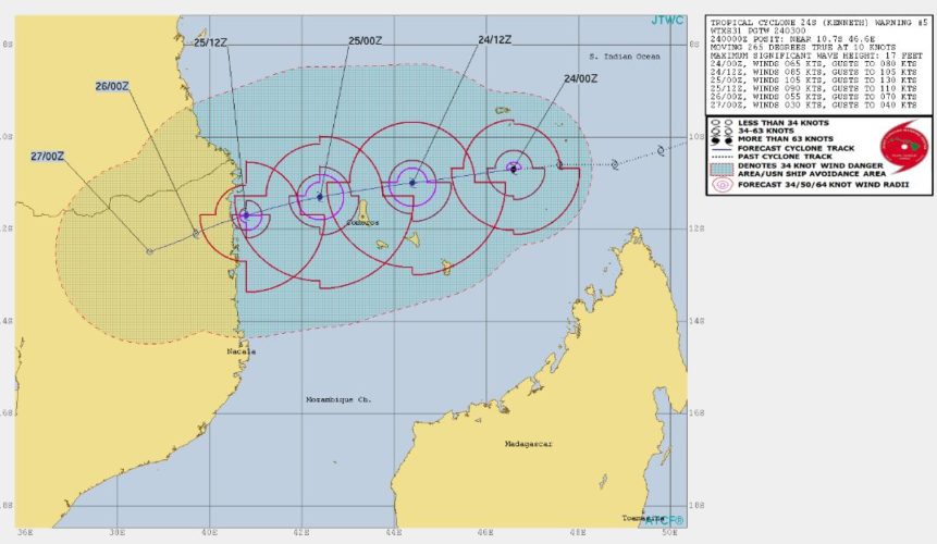
As the people of Mozambique struggle to recover from the recent cyclone Idai that struck the country last month killing over 1000 people- another Cyclone by the name Kenneth is set to make landfall over the northern part of the country by April 26.

While making landfall the intensity of the cyclone will however reduce to become Cat I. Which should be a huge relief compared to the strength of the previous cyclone.

The countries of Mozambique and Malawi are set to bear the brunt this time. On its way the cyclone is set to hit the famous island beach of Moroni.

The island archipelago of Comoros could bear the worst impacts of Kenneth, wind-wise. Winds at the speed of 103 mph—the equivalent of a Category 2 storm, is expected to blow over this island.

Located in the Indian Ocean, the position of the system is at 10’6°S and 48’8°E. Moving West-southwestwards it is moving in the Mozambique Channel at present. The intensity of the system is set to intensify into Cat I, strengthening into a Cat II later. When it reaches the coastline, it might reduce to Cat I yet again.

Image Credit: www.metoc.navy, IRIN News

Please Note: Any information picked from here must be attributed to skymetweather.com

South Africa: Death toll from floods and mudslides rise to 33

According to local authorities, the death toll from floods and mudslides that crushed homes in the South African port of Durban yesterday has risen to 33, with reports of children missing and many people displaced.

Among those killed was a six-month-old baby. In fact, 10 children are missing in Durban and 42 people have been injured. At least 145 people have been displaced.

In the recent days, heavy rains have lashed South Africa, with the eastern parts of the country badly hit since the start of Easter weekend.

In fact, during the last 24 hours, heavy rain and thundershower activities accompanied with strong winds have resulted in massive flooding over the area.

Government said that dozens of incidents of collapsed walls and flooded homes were reported throughout the night. Moreover, those killed were either crushed to death by mudslides or drowned in flood waters.

In addition to collapsed buildings and flooded roads, sewer lines were blocked, and electricity pylons had collapsed over. Search and rescue operations have begun from the governments end.

Further, we expect heavy rains along with strong winds to continue for another 24 hours, thus risk of more causalities and damage is still high. Thereafter, weather activities will gradually start receding from the region.

Image Credit: Wikipedia

Please Note: Any information picked from here must be attributed to skymetweather.com

[Hindi] चक्रवाती तूफान ‘फ़ानी’ विकसित हो सकता है बंगाल की खाड़ी में

इस सीजन का पहला चक्रवात विकसित होता दिखाई दे रहा है। अनुमान है कि बंगाल की खाड़ी में अगले सप्ताह की शुरुआत में चक्रवाती तूफान बन सकता है। हालांकि खाड़ी में उठे इस सिस्टम को अभी लंबी यात्रा तय करनी है। इसकी लंबी यात्रा से ही चक्रवाती तूफान की दिशा और इसकी क्षमता का पता चलेगा। आइए एक नजर डालते हैं संभावित तूफान की दिशा क्षमता और इससे जुड़े अन्य पहलुओं पर।

अगर बंगाल की खाड़ी में सिस्टम प्रभावी होकर चक्रवाती तूफान बनता है तो इस सीजन का पहला तूफान होगा और इसे फ़ानी नाम दिया जाएगा।

चक्रवात की सफ़र

इस समय यह सिस्टम हिंद महासागर में भूमध्य रेखा के पास और दक्षिण पूर्वी बंगाल की खाड़ी के सुदूर क्षेत्रों पर एक कमज़ोर चक्रवाती क्षेत्र के रूप में दिखाई दे रहा है। मौसम विशेषज्ञों के अनुसार यह सिस्टम शुरुआत में उत्तर पश्चिमी दिशा में आगे बढ़ेगा और अगले 24 घंटों के दौरान यह और प्रभावी बनेगा। उम्मीद है कि 25 अप्रैल को यह सिस्टम निम्न दबाव के क्षेत्र में तब्दील हो जाएगा और बंगाल की खाड़ी के दक्षिण-पश्चिमी भागों तथा इससे सटे हिंद महासागर पर पहुंच जाएगा।

Also Read In English: POTENTIAL CYCLONE FANI TO FORM SOON IN BAY OF BENGAL

संभावित मौसमी सिस्टम 26 अप्रैल तक सशक्त होते हुए डिप्रेशन बन सकता है और बंगाल की खाड़ी के दक्षिण पश्चिमी हिस्सों तथा हिंद महासागर के भागों पर पहुंच सकता है। उसके बाद भी वायुमंडलीय स्थितियां इसके पक्ष में रहेंगी जिससे यह लगातार सशक्त होता रहेगा और पहले डीप डिप्रेशन बनेगा उसके बाद अगले 3 दिनों में यानी 29 अप्रैल तक आखिरकार चक्रवाती तूफान का रूप ले लेगा।

अनुकूल मौसम स्थितियां

यह सिस्टम जिस स्थान पर उठ रहा है उससे आगे की पूरी की पूरी यात्रा में इसे मौसमी स्थितियों का भरपूर सहयोग मिलेगा। चक्रवाती तूफान बनने के लिए कुछ निश्चित मौसमी स्थितियां अनुकूल होनी आवश्यक हैं, जो निम्नलिखित हैं:

  1. समुद्र की सतह का तापमान : समुद्र में विकसित हुए किसी भी सिस्टम के लिए चक्रवात बनने से पहले उसे लंबी समुद्री यात्रा तय करने की जरूरत होती है। समुद्र की सतह का तापमान 26 डिग्री सेल्सियस से ऊपर होना भी आवश्यक है। इस समय बंगाल की खाड़ी के साथ-साथ हिंद महासागर क्षेत्र में समुद्र की सतह का तापमान 30 से 35 डिग्री सेल्सियस के बीच चल रहा है जो स्पष्ट रूप से सिग्नल है चक्रवाती तूफान के विकसित होने के लिए अनुकूल मौसम का।
  2. वर्टिकल विंड शीयर : समुद्री सिस्टम के प्रभावी होने के लिए विंड शीयर नीचे होना जरूरी है। इस समय इस सिस्टम के पास विंड शीयर नीचे ही है, जिससे सिस्टम के धीरे-धीरे प्रभावी होने में मदद मिलेगी।
  3. लंबी समुद्री यात्रा : जब किसी सिस्टम की समुद्री यात्रा लंबी होती है तब इसके प्रभावी होने के आसार बहुत अधिक होते हैं। संभावित चक्रवाती का पूर्ववर्ती सिस्टम तूफान बंगाल की खाड़ी के सुदूर दक्षिण पूर्वी भागों और इससे सटे हिंद महासागर के ऊपर है। यानि इसे एक लंबा समुद्री सफर तय करना है जो निश्चित तौर पर सिस्टम के आसपास आर्द्रता को निरंतर इकट्ठा करने में मदद करेगा, जिससे यह सिस्टम प्रभावी बनेगा।
  4. एमजेओ : माडन जूलियन ओषिलेशन, एक महत्वपूर्ण मौसमी पहलू जो इस समय हिन्द महासगर से होकर गुज़र रहा है। यह मौसमी स्थितियों को चक्रवात के पक्ष में बनाएगा।
  5. आई टी सी ज़ेड : इंटरट्रॉपिकल कन्वर्जेंस जोन, यानी आईटीसीज़ेड वर्तमान समय में हिंद महासागर में भूमध्य रेखा के पास है और यह चक्रवाती तूफान को बनाने में मदद करेगा।

क्षमता

खाड़ी में उठने वाले सिस्टम के चक्रवाती तूफान बनने की पूरी संभावना है। हालांकि सभी अनुकूल परिस्थितियों के बावजूद हमारा अनुमान है कि डरने की जरूरत नहीं है, क्योंकि यह एक भीषण चक्रवाती तूफान बनता दिखाई नहीं दे रहा। इसके पीछे कारण यह है कि संभावित चक्रवाती तूफान निचले लैटीट्यूड पर यात्रा करेगा और भूमध्य रेखा के काफी करीब होगा। तय नियमों को अगर देखें तो भूमध्य रेखा के पास विकसित होने वाला सिस्टम बहुत ज्यादा प्रभावी नहीं होता है।

तूफान की दिशा : चक्रवाती तूफान की दिशा क्या होगी यह निश्चित कर पाना अभी मुश्किल है। मौसम से जुड़े मॉडल इसकी दिशा को लेकर एक मत नहीं है। कुछ मॉडल संकेत कर रहे हैं कि यह भारत के तटीय भागों के पास चेन्नई के करीब से लैंडफॉल करेगा जबकि अन्य मॉडल बता रहे हैं कि यह बंगाल की खाड़ी में शुरुआती सफर के बाद अपनी दिशा बदलेगा और बांग्लादेश तथा म्यांमार की ओर जाएगा।

इसकी दिशा कोई भी हो लेकिन यह तो लगभग तय है कि चेन्नई सहित तमिलनाडु के तटीय भागों में वर्षा देखने को मिलेगी नीचे हालांकि इसकी दिशा पर यह निर्भर करेगा कि चेन्नई सहित भारत के पूर्वी तटों पर बारिश कितनी होगी।  नीचे दिए गए मैप में हमने इसकी संभावित दिशा को दिखाने का प्रयास किया है।

Possible track of Cyclone Fani

पहली संभावना अगर प्रबल होती है तो चेन्नई सहित तमिलनाडु के तटीय भागों पर भीषण बारिश होगी। दूसरी संभावना के अनुसार इन भागों में हल्की से मध्यम बारिश देखने को मिलेगी जबकि तीसरी संभावना में बारिश और कम देखने को मिलेगी। हालांकि अभी लगभग 6 दिन का समय बाकी है। जैसे-जैसे दिन बीतते जाएंगे सिस्टम आकार लेता जाएगा और इस सप्ताह के आखिरी तक तस्वीर साफ होती जाएगी।

Image Credit: The Buffalo News

कृपया ध्यान दें: स्काइमेट की वेबसाइट पर उपलब्ध किसी भी सूचना या लेख को प्रसारित या प्रकाशित करने पर साभार: skymetweather.com अवश्य लिखें।


Pre Monsoon rain in Ambala, Pathankot and Amritsar, thundershowers on April 25 and 26

Pre Monsoon Rain in Punjab

The state of Punjab last received rains on April 17. Since then the temperatures have been rising gradually. Although occasional feeble Western Disturbances approached the Western Himalayas, they failed to impact the northern parts of Punjab and Haryana.

Now, a fresh Western Disturbance is approaching Jammu and Kashmir. And scattered rains have already occurred over some parts of the state.  An induced Cyclonic Circulation has also built up over North Rajasthan. Due to the combined affect of these weather systems, we expect scattered light to moderate rains to occur over the northern districts of Punjab and Haryana on April 25 and 26. Panchkula, Ambala, Kurukshetra, Sirsa in Haryana and Pathankot, Gurdaspur, Amritsar and Hoshiarpur in Punjab would witness these pre-Monsoon rain and thundershowers. However, isolated thunderstorm activity or light rains might commence by the evening of April 24.

The intensity is expected to increase by April 25. The easterly winds have already commenced leading to increase in humidity levels in the region. The temperatures are already high and whenever the temperatures are high with increased humidity levels, instability in atmosphere increases giving rise to thunderclouds.

Hence, isolated thundershower with strong winds also cannot be ruled out over the northern districts of both the states. The weather of southern districts of Punjab and Haryana would be dry and warm. This means Patiala, Bhatinda, Mansa in Punjab and Jhajjar, Palwal, Rewari in Haryana would witness warm and dry weather. By April 27, the weather system would move eastward leading to clear skies and rise in temperatures.

In the rain affected areas, temperatures are likely drop by three to five degrees while in other areas marginal drop would be witnessed.

Image Credit: Hindustan Times

Please Note: Any information picked from here must be attributed to skymetweather.com

Twin earthquakes of magnitude 5.9 and 5.2 hit Arunachal Pradesh and Nepal

An earthquake of moderate intensity measuring magnitude of 5.9 on the Richter Scale struck India's northeastern state of Arunachal Pradesh around 1.45 am on Wednesday. The epicenter of the quake was about 33 kilometers north/northwest of Along, with depth of 14 km.

According to the state government's website, Arunachal Pradesh is India's least densely populated state, but is still home to more than 1.2 million people.

USGS estimated there was a "low likelihood" of casualties and damage from the earthquake.

This was followed by three earthquakes in Nepal in the morning measuring up to 5.2 on the Richter Scale. The first tremor of 4.8 magnitude was felt at 6:14 am in Kathmandu, followed by two tremors in Naubise in Dhading at 6:29 am and 6:40 am, respectively.

The three quakes come a day before Nepal marks four years of the devastating earthquake that claimed more than 8,000 lives and injured more than 20,000 on April 25, 2015.

Many officials in China have also reported that the tremors of earthquake in India was also felt in Tibet. Myanmar and Bhutan, two other countries that share a border with Arunachal Pradesh, have not reported any such activity till now.

Image Credit: USGS

Please Note: Any information picked from here must be attributed to skymetweather.com


latest news