Skymet weather

Mysore, Bengaluru, Thiruvananthapuram and Kochi on rain alert for next 2 days

Kerala rains

The parts of South Karnataka and Kerala have been experiencing light rain and thundershower activities for the last few days. According to the data available with Skymet, during the last 24 hours, Kozhikode in Kerala has recorded 2 mm of rainfall, while traces of rain have been recorded in Gadag, Karnataka.

The reason for these activities can be attributed to the Trough, which is extending from Central Madhya Pradesh up to North Kerala. In addition to this Trough, a Cyclonic Circulation has formed over the coastal areas of South Karnataka and adjoining Arabian Sea. Both the systems are oscillating almost close to periphery, thereby giving rains.

Also read: FANI TO INTENSIFY INTO SEVERE CYCLONE BY SUNDAY AFTERNOON, VERY SEVERE CYCLONE IN 24 HRS

As the systems will persist for some more time, rain and thundershowers will continue over few parts of South and Coastal Karnataka and Kerala for the next 48 hours. Thus, we expect light to moderate rain and thundershowers, along with isolated moderate spell, accompanied with strong gusty winds over Mysore, Bengaluru, Mangaluru, Chitradurga, Chamarajanagar, Thiruvananthapuram, Kannur, Kozhikode and Kochi for next two days. These activities will commence today late afternoon or evening onward.

However, northern parts of Karnataka will remain unaffected by this system and continue with hot and humid weather, along with isolated heat wave conditions.

After 48 hours, these activities will gradually decrease, as the severe Cyclonic Storm 'Fani' which is presently over Southeast Bay of Bengal will move closer to Tamil Nadu coast. As a result, the wind pattern over most parts of southern peninsula will change and become north-westerlies/westerlies from April 30. Thus, we expect weather to go completely dry on April 30 over most parts of Karnataka and Kerala.

Image Credits – Pinterest

Any information taken from here should be credited to Skymet Weather

Fani to intensify into severe cyclone by Sunday afternoon, very severe cyclone in 24 hrs

Chennai rains

As predicted by Skymet Weather, the Cyclonic Storm Fani is now all set to become more powerful as we can expect it to intensify into a severe cyclonic storm by Sunday afternoon.

Presently it is positioned at Latitude 7.3°N and Longitude 87.9°E over southeast Bay of Bengal and adjoining areas. This is around 740 km east­southeast of Trincomalee, Sri Lanka, 1000 km southeast of Chennai and 1220 km south­southeast of Machilipatnam.

Fani has been a slow moving system and in the last few hours, it has been moving at a speed of 13 kmph-15 kmph.

Cyclonic storm Fani has been continuously gaining latitude but weather conditions are still very much favourable for its further intensification. Sea surface temperatures have been very warm to the tune of 31°C and vertical wind shear has also been low. Thus, likely severe cyclonic storm Fani would soon in the next 24 hours would upgrade its status to a Very Severe Cyclonic Storm.

Cyclone Fani would be most powerful when it would be near north Coastal Tamil Nadu and adjoining South Coastal Andhra Pradesh.

The system is expected to now change direction slightly and would track northwestwards till May 1. Thereafter, it is likely to recurve northeastwards gradually. During this time, vertical wind shear would start increasing and weathermen are predicting system to start weakening by May 3.

Image Credit:en.wikipedia.org

Any information taken from here should be credited to skymetweather.com

When to visit Mount Abu, the Shimla of Rajasthan

The one and only hill station in Rajasthan, Mount Abu, also famously called the ‘Shimla of Rajasthan’, lies on the foothills of Aravali hill range at an altitude of 1220 m.

Also considered, 'an oasis in the desert', its heights are home to rivers, lakes, waterfalls and evergreen forests.

The most important attraction in the place is the Dilwara temples. If you are a history buff or have a little flair for architecture, this is exactly the place for you!

This is when you should visit this town-

Winters (November - February)

Mount Abu experiences pleasant weather in Winters. It is also the best time for sightseeing and other adventurous activities like trekking.

The winters are generally cold with the temperature reaching a low of about 12°C with the maximum temperature of about 29°C.

Monsoon (July - October)

Mount Abu receives moderate rainfall in Monsoon. For nature lovers, monsoons are an ideal time to visit Mount Abu. Even though the region receives less rainfall, these short spells of rain make the place fresher and greener.

Summer (March - June)

Mount Abu can be visited in Summers as well as the weather is not very hot. The temperature ranges from a minimum of 23°C to a maximum of 33°C. Days are pleasant and nights are generally cool.

So, in a nutshell, the best time to visit Mount Abu is all round the year as the climate remains constantly pleasant.

Places to visit and things to do in Mount Abu

The exceptionally intricate architecture of the Dilwara temples are of course the main attraction here. If architecture is not your thing, then there are various lakes and viewpoints such as the Honeymoon Point, Sunset Point, etc. Tourists can enjoy boating in the Nakki lake, and a view of the sunset from the Sunset point.

The highest peak of the Aravali Range also lies in Mt. Abu, surrounded by dense green forests. Also, the place is the headquarters to Brahma Kumaris.

Image Credits – Condé Nast Traveller IndiaIndianHoliday 

Any information taken from here should be credited to Skymet Weather

At 42.9 degrees Pune in Maharashtra breaks record of last 36 years

At present many parts of Maharashtra are experiencing heat wave conditions. Temperatures are being recorded at 45°C or more at many places particularly in the Vidarbha, Marathwada and Madhya Maharashtra region.

Moreover yesterday, the city of Pune recorded 42.9°C yesterday which was the highest recorded temperature for the city in the last 36 years. The all-time record for Pune stands at 43.3°C recorded on April 30, 1897.

Areas such as Malegaon and Jalgaon too are recording day temperatures at 45°C or more.

Find India's Top 10 Hottest Places for yesterday, here!

At present the highest temperature across the country are being experienced over the Vidarbha region particularly in the cities of Akola, Wardha, Chandrapur, Gondia, Amravati, Bramhapuri. Almost all these stations are recoding temperatures in the tune of 45°C or more.

These heat wave conditions are due to the continuous dry spell over the state combined with the hot and dry winds blowing from North and Northwest direction. As these winds are blowing from the dry and hot region of Central Pakistan, Rajasthan and West Madhya Pradesh, thus increasing the temperatures over Maharashtra.

We do not expect any relief from such weather at least for the next 4 to 5 days in the absence of any major weather activity.

A slight relief is in sight by May 2 or 3, when the temperatures might subside by 2 to 3 degrees as a Cyclone which is forming over Bay of Bengal will move along the coast, leading to influx of humid winds over the state from Bay of Bengal. Until that time the state will have to battle extreme temperatures.

Image Credits – Zee News 

Any information taken from here should be credited to Skymet Weather

Tamil Nadu on alert with Cyclone Fani set to intensify into severe cyclonic storm

Cyclone Fani track

The wait for season’s first cyclonic storm is finally over, with Fani making an appearance over Southeast Bay of Bengal and Equatorial Indian Ocean on Saturday afternoon. Not only this, weather conditions are ripe enough for the tropical storm to strengthen into severe cyclonic storm by Sunday.

Weather models are also indicating that since it is a slow moving system, it also has the potential to become a very severe cyclonic storm also. However, we need to wait and watch for the same.

The system is presently centred at Latitude 5.4°N and Longitude 88.5°E, about 870 km east­southeast of Colombo, Sri Lanka, 1200 km southeast of Chennai and 1440 km south­southeast of Machilipatnam.

The system would be now tracking northwestwards off the Sri Lanka coast and thereafter it is likely to re-curve and move along the East Coast, right from Tamil Nadu to West Bengal and finally heading towards West Bengal.

At present, it still brewing far away in the sea. Hence, for the next 24-36 hours, intense rains would be confined to sea only. Thereafter, intense rains, high-velocity winds and rough sea conditions would be seen all along the coastal areas of Tamil Nadu and Andhra Pradesh.

According to weathermen, we can expect moderate rain and thundershowers with few intense showers from April 29 evening. According to weathermen, Cyclone Fani is likely to peak when it would be near Chennai i.e. around 300 km from the state capital. It is likely to give more rains along the Tamil Nadu coast during that time.

Sea conditions very likely to be rough to very rough along and off Puducherry, coastal Tamil Nadu and south coastal Andhra Pradesh till May 1. Locals and fishermen are advised not to venture out in the sea during that time.

Image Credit:en.wikipedia.org

Any information taken from here should be credited to skymetweather.com

28 अप्रैल का मौसम पूर्वानुमान: फ़ानी लेगा भीषण चक्रवाती तूफान का रूप, अंडमान व निकोबार पर भारी बारिश


दक्षिण भारत से शुरुआत करें तो, एक डीप डिप्रेशन अब चक्रवाती तूफान फ़ानी में तब्दील हो गया है और दक्षिणपूर्वी बंगाल की खाड़ी पर बना हुआ है। अनुमान है, कि ये अगले 24 घंटों में एक भीषण चक्रवाती तूफान का रूप ले लेगा। ये सिस्टम अंडमान व निकोबार द्वीप समूह पर तेज़ हवाओं के साथ मध्यम से भारी बारिश देगा। 30 अप्रैल तक इस सिस्टम के तमिलनाडु तट पर पहुँचने का अनुमान है।

इसके अलावा एक ट्रफ रेखा पूर्वी मध्य प्रदेश से केरल तक जा रही है। ये सिस्टम, केरल और तटीय कर्नाटक पर हल्की से मध्यम बारिश देगा। तमिलनाडु में भी एक-दो जगह बारिश हो सकती हैं। इस समय गरम और नम दक्षिणपूर्वी हवाएँ आंध्र प्रदेश और तेलंगाना को प्रभावित कर रही हैं। जिसके चलते, यहाँ कुछ इलाकों में बारिश और गरज-बौछारें होंगी।

पूर्वी और उत्तर-पूर्वी भारत कि बात करें तो, एक चक्रवाती हवाओं का क्षेत्र उप-हिमालयी पश्चिम बंगाल और साथ लगे क्षेत्रों पर बना हुआ है। एक ट्रफ इस सिस्टम से ओड़ीशा तक जा रही है। इसके चलते, उत्तर-पूर्वी राज्यों में, हल्की से मध्यम वर्षा का अनुमान है।

साथ ही, पश्चिम बंगाल कि कई जगहें जैसे जलपाईगुरि, सिलीगुड़ी, बांकुरा और पुरुलिया में भी ये बारिश देखी जा सकती है। ओड़ीशा कि एक-दो जगहें जैसे कोरापुट, मलकानगिरी और रायगड में भी छिट-पुट बारिश होने का अनुमान है। हालांकि, झारखंड में हीट वेव कि स्थिती जारी रहेगी।

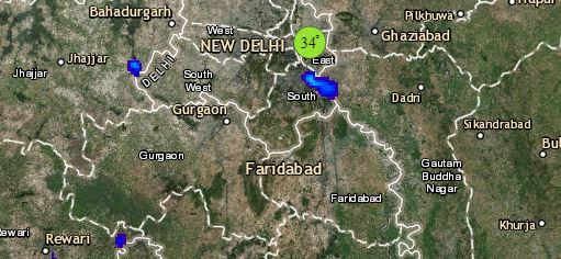
Click the image below to see the live lightning and thunderstorm across IndiaRain in India 

ऊपर उत्तर भारत में, एक कमजोर पश्चिमी विक्षोभ जम्मु-कश्मीर पर बना हुआ है। ये अपने साथ, जम्मु-कश्मीर और हिमाचल प्रदेश में हल्की बारिश देगा। एक प्रेरित चक्रवाती हवाओं का क्षेत्र पश्चिमी राजस्थान पर बना हुआ है। इसके चलते, राजस्थान के पश्चिमी भागों जैसे बीकानेर, जोधपुर, जैसलमर और पाली में तेज़ हवाएँ और धूल भरी आँधी चलने का अनुमान है। इसके अलावा, दक्षिणी हरियाणा, दिल्ली के कुछ भाग और दक्षिणी उत्तर प्रदेश में हीट वेव कि स्थिति बनी रहेगी।

अंत में मध्य भारत की बात करें तो, यहाँ पर मौसम शुष्क और गरम बना रहेगा। राजस्थान, गुजरात, मध्य प्रदेश, छत्तीसगढ़, विदर्भ और उत्तरी महाराष्ट्र में हीट वेव की स्थिति बनी रहने का अनुमान है।

Any information taken from here should be credited to skymetweather.com


Weather Forecast April 28: Depression intensifies into Cyclone Fani, heat wave in North and Central India


Beginning with South India, the Deep Depression has further intensified into a Cyclonic Storm Fani and lies over Southeast Bay of Bengal. It is likely to intensify into a Severe Cyclonic Storm during next 24 hours. This system would give moderate to heavy rain and thundershowers with strong winds over Andaman and Nicobar Islands. This system would move in northwest direction and head towards Tamil Nadu coast and reach the region by April 30. It would then re-curve from there and start moving in North/Northeast direction.

Also, an upper air trough is extending from East Madhya Pradesh to Kerala across Vidarbha and Karnataka. Due to this weather system, light to moderate rain and thundershowers would be affecting some places in Kerala and South Coastal Karnataka while isolated activities will be seen in Tamil Nadu.

The warm and moist southeasterly winds would be affecting Andhra Pradesh and Telangana. Hence, places like Machilipatnam, Kakinada, Vishakhapatnam and Khammam would see light pre-Monsoon rain and thundershowers. Whereas, isolated pockets of Telangana would see heat wave conditions.

Heading towards East and Northeast India, a Cyclonic Circulation is over Sub Himalayan West Bengal and Sikkim and its adjoining region. An upper air trough is extending from this system up to Odisha across Bihar, Jharkhand and West Bengal. Due to the presence of these weather systems, light to moderate rain and thundershowers would be affecting many places in northeastern states like Arunachal Pradesh, Meghalaya, Assam and Nagaland. It would also be affecting some places in West Bengal like Jalpaiguri, Siliguri, Bankura and Purulia. Isolated activities can be witnessed in Koraput, Malkangiri and Rayagada in Odisha. Isolated pockets of Jharkhand might witness heat wave conditions.

Click the image below to see the live lightning and thunderstorm across IndiaRain in India

Up in North, a feeble Western Disturbance as an upper air trough lies over north of Jammu and Kashmir. Hence, light rain might affect the upper reaches of Jammu and Kashmir and Himachal Pradesh. Its induced Cyclonic Circulation is over West Rajasthan. Due to the system, isolated dust storm activity with strong winds might affect the western parts of Rajasthan like Bikaner, Jodhpur, Jaisalmer and Pali. Also, heat wave and heat wave type conditions would be affecting South Haryana, some parts of Delhi and South Uttar Pradesh.

Lastly, in Central India, dry and hot weather conditions would continue here. Heat wave conditions will be prevalent across rest parts of Rajasthan, Gujarat, Madhya Pradesh, Chhattisgarh, Vidarbha and North Maharashtra.

Any information taken from here should be credited to skymetweather.com


[Hindi] चक्रवात फानी, बंगाल की खाड़ी में 1891 के बाद का दूसरा सबसे भयानक तूफ़ान हो सकता है

चक्रवात फ़ानी 2019 में प्री-मॉनसून सीज़न में उठने वाला पहला समुद्री तूफान है। बंगाल की खाड़ी में तूफ़ान फ़ानी शनिवार विकसित हुआ। संभावना है कि रविवार को यह एक भीषण चक्रवाती तूफ़ान का रूप ले सकता है। अगर ऐसा होता है तो बंगाल की खाड़ी में 1891 के बाद यह दूसरा सबसे भयंकर तूफ़ान होगा।

इससे पहले 25 अप्रैल 2006 में आये 'माला चक्रवात' भी बहुत भयानक चक्रवात था। इसके अलावा अप्रैल महीने में सिर्फ 11 चक्रवात देखने को मिले हैं।

मौसम विशेषज्ञों के अनुसार, अप्रैल के शुरूआती आधे महीने में भारतीय समुद्र में बहुत ही कम चक्रवाती तूफ़ान देखने को मिले हैं इसके अलावा आखिरी आधे महीने में भी इन तूफानों की संख्या कम ही रही।
चक्रवात फ़ानी वर्तमान में दक्षिण पूर्वी बंगाल की खाड़ी और इससे सटे हुए हिन्द महासागर में भूमध्य रेखा के ऊपर गहरे है।

वर्तमान में यह सिस्टम 4.9° उत्तरी अक्षांश, 88° पूर्वी दिशा की ओर, श्रीलंका के कोलंबो से करीब 800 किलोमीटर, चेन्नई से 1160 किमी दक्षिण-पूर्वी और मछलीपट्टनम से 1460 किमी दक्षिण-दक्षिण पूर्वी दिशा में बना हुआ है।


Also Read In English: PROBABLE STORM FANI MAY BECOME A SEVERE CYCLONE BY SUNDAY, SECOND SINCE 1891 IN APRIL

यह सिस्टम बेहद अनुकूल मौसम में आगे बढ़ रहा है, जिसके कारण अगले 24 घंटों में चक्रवाती तूफ़ान और प्रभावी होकर भीषण चक्रवात का रूप ले सकता है। पहले यह श्रीलंका और केरल को प्रभावित करेगा उसके बाद देश के पूर्वी तटों पर इसका असर देखने को मिलेगा।

अगले 72 घंटों में यानि 28 से 30 अप्रैल के बीच तूफान फ़ानी के कारण दक्षिण भारत के कुछ भागों बारिश देखने को मिलेगी। खासकर केरल, तटीय तमिलनाडु, पुद्दुचेरी और तटवर्ती आंध्र प्रदेश में हल्की से मध्यम बारिश की संभावना है।

Image Credit: Scroll.in

कृपया ध्यान दें: स्काइमेट की वेबसाइट पर उपलब्ध किसी भी सूचना या लेख को प्रसारित या प्रकाशित करने पर साभार: skymetweather.com अवश्य लिखें

Is Cyclone Lorna restricting strength of Cyclone Fani?

Cyclone Fani has been a slow system, be it in terms of its intensity or its movement. It remained as a low pressure area for quite a long time in Bay of Bengal, gradually intensifying into a depression that too stayed for over 24 hours.

Fani did manage to pick up some pace after it became deep depression and its intensification into a cyclonic storm over Southeast Bay of Bengal and Equatorial Indian Ocean was comparatively much quicker.

Well, the reason behind this slow progress of the system could be linked with another tropical storm brewing in Indian Ocean but on other side of the Equator. Tropical storm Lorna is brewing in Indian Ocean in Southern Hemisphere and is centered at Latitude 12°S and Longitude 90°E. However, it is a much stronger system i.e. of category 1 storm.

Meanwhile, Cyclone Fani is n Southeast Bay of Bengal and Equatorial Indian Ocean in Northern Hemisphere. It is presently centered at Latitude 5.4°N and Longitude 88.5°E, about 870 km east­-southeast of Colombo, Sri Lanka, 1200 km southeast of Chennai and 1440 km south­southeast of Machilipatnam.

According to weathermen, both the tropical storms are aligned on either side of the Equator. Whenever any two powerful systems form in the close proximity, both the systems hold on to each other, making their progress slow, especially when they are in the opposite hemisphere.
Also, during such times, one system gets stronger, while the other one gets consumed.

However, in this scenario both Lorna and Fani are moving in opposite direction and gaining latitude in respective hemispheres. Thus, the distance between them is increasing, which at present is about 1000 km.

In wake of this, both the tropical storms have picked up pace, intensity as well as speed wise. In fact, going further, both the systems would now get more powerful. Thus, we are expecting Fani to be initially become a severe cyclone in next 24 hours and further into a very severe cyclone in subsequent 24 hours.

Image Credit:en.wikipedia.org

Any information taken from here should be credited to skymetweather.com

IPL 2019: RR VS SRH clash to take place amidst hot weather in Jaipur

ipl srh vs rr

The 12th season of IPL is all charged up to host its 45th match today between Rajasthan Royals and Sunrisers Hyderabad at 8 pm. The clash will take place in Rajasthan’s home ground stadium i.e. at Jaipur’s Sawai Man Singh Stadium.

Rajasthan Royals have successfully defeated two-time winner Kolkata Knight Riders at their home ground and the team is all set to take the legacy forward by playing against Sunrisers Hyderabad today.

Weather conditions in Jaipur

According to Skymet, Jaipur will witness dry weather and clear skies, with absolutely no chances of rain. During the match, the temperature will remain between 35℃ and 36℃. The high temperature may be a little troublesome for the players as well as the audience. However, due to light winds from the north and north-east direction, there may be slight relief from heat as the match progresses.

A glance at the IPL statistics

Both the teams have played 10 matches against each other till date. Four out of these have been won by Rajasthan, while six by Sunrisers. Talking about the matches played at Sawai Man Singh Stadium, then both the teams have won one match each.

According to the points table, Sunrisers Hyderabad is in fourth place, after winning five out of 10 matches. On the other hand, Rajasthan is standing at the seventh position by winning four out of 11 matches.

Fans will miss their favourite players

In today’s match, Rajasthan will miss their important players, Ben Stokes and Jofra Archer. Similarly, the fans of Sunrisers Hyderabad will miss their star player Johnny Bairstow.

Talking about last match

In the match played yesterday, Mumbai Indians (MI) defeated Chennai Super Kings (CSK) by 46 runs. Mumbai Indians scored 155 runs for 4 wickets in the first innings. In return, Chennai Super Kings could make only 109 runs in 17.4 overs, by losing all wickets. With this victory, Mumbai has come closer to qualify for play-offs. In the 11 matches played, Mumbai has got 14 points and it has secured number two position after Chennai Supper King in the points table.

Image Credits – Pinterest

Any information taken from here should be credited to Skymet Weather

[Hindi] शुक्रवार को दुनिया के सबसे गर्म 15 शहरों की सूची में सभी शहर भारत के

Top 15 Hottest Cities Of the World

बढ़ रहे तापमान के कारण दुनिया भर में गर्मी अपने चरम पर है। हालात ऐसे हो गए हैं कि लोगों के लिए घरों से निकलना भी मुश्किल हो गया है। इस बीच इससे जुड़ी एक चौंकानेवाली रिपोर्ट सामने आई है। जिसमें खुलासा हुआ है कि इस गर्मी के बढ़ते प्रकोप का सबसे ज्यादा असर भारत पर ही दिख रहा है। दरअसल, शुक्रवार को सबसे गर्म शहरों की एक लिस्ट जारी हुई है। इसमें शुक्रवार को शाम 7.30 बजे के तापमान को पैमाना बनाया गया था। बता दें कि, बीते शुक्रवार को कई भारतीय शहरों में पारा चढ़ा रहा और लोगों को गर्म हवा के झोंकों का सामना करना पड़ा।

अल डोराडो मौसम वेबसाइट की रिपोर्ट के अनुसार दुनिया के 15 सबसे गर्म शहरों की लिस्ट में सभी मध्य भारत और उसके आसपास के क्षेत्र ही शामिल रहे। वहीं, इस लिस्ट में 46.6 डिग्री सेल्सियस तापमान के साथ मध्य प्रदेश का खरगोन शहर पहले स्थान पर रहा।

इस लिस्ट में जो 15 नाम शामिल हैं उसमें से 9 महाराष्ट्र, 3 मध्य प्रदेश, दो उत्तर प्रदेश और एक तेलंगाना का है।इस लिस्ट के मुताबिक नागपुर (45.2 डिग्री) दुनिया के गर्म शहरों में 9 वें नंबर पर रहा। क्षेत्रीय मौसम विज्ञान केंद्र (आरएमसी) ने भी माना कि वहां के लिए यह सीजन का सबसे गर्म दिन था।

इसके अलावा इस लिस्ट में विदर्भ क्षेत्र के कुछ और जगह शामिल हैं जहाँ का तापमान 45 डिग्री के पार रहा। इनमे अमरावती (45.4), ब्रह्मपुरी (45.8), चंद्रपुर (45.6) और वर्धा (45.7) भी शामिल हैं।

स्काईमेट के मौसम वैज्ञानिकों के अनुसार, अगले 2-3 दिनों में मध्य प्रदेश और विदर्भ के कई स्थानों पर दिन का तापमान में बढ़ोतरी के आसार हैं। जो कि बढ़कर 45 से 47 डिग्री सेल्सियस के बीच रहने की उम्मीद है।इसके अलावा, पंजाब, हरियाणा, राजस्थान, गुजरात, छत्तीसगढ़ सहित आंतरिक ओडिशा और तेलंगाना के कुछ हिस्सों में भी तापमान बढ़कर 40 डिग्री के आसपास हो जाने की संभावना है। साथ ही, दिल्ली के लोगों को भी बढ़ रहे तापमान के कारण असहनीय गर्मी का सामना करना पड़ सकता है।

Also Read In English : 15 HOTTEST CITIES OF THE WORLD ON FRIDAY WERE IN INDIA

Image Credit: Times of India

कृपया ध्यान दें: स्काइमेट की वेबसाइट पर उपलब्ध किसी भी सूचना या लेख को प्रसारित या प्रकाशित करने पर साभार: skymetweather.com अवश्य लिखें।

The very interesting process of naming Cyclones

Cyclone and names

Naming of cyclones

Traditionally, cyclones were not named! The trend started with frequent hurricanes hitting the Atlantic Ocean. A basic criteria was set that the tropical storms that sustain wind speed of 39 miles per hour would be given different names. It is quite amazing to know that hurricanes, cyclones and typhoons are all the tropical storms, just called out with the different names in different corners of the world. Thus, storms in the Atlantic are known as ‘Hurricanes’, as ‘Typhoon’ in the Pacific, while ‘Cyclone’ in the Indian Ocean.

Classification of storm

On the basis of wind speed, storms are classified as a hurricane/cyclone/typhoon. Only if the speed of wind reaches 74 mph or above, the storm is classified into the above three categories.

Naming started hundreds of years back!

Storms in the Atlantic were given names hundred years ago. During the initial time, residents of the Caribbean Islands used to name the storm post the saint of the day, according to the Roman Catholic liturgical calendar for that day on which the hurricane or cyclone had popped up.

This trend continued until World War II, wherein the forecasters and meteorologists came up with the idea of identifying the storms by giving them female names. The US weather service liked and adopted this idea and thus in 1953, the company developed a new international phonetic alphabet as per different women’s names starting with letter A up to W. Letters Q,U,X,Y and Z were not included.

However, the idea faced subsequent protests in the 60s and 70s by different women’s liberation bodies. As a result, the naming procedure was changed and started including male names in 1978.

Further, in even-numbered years, odd-numbered storms were given men's names, while in odd-numbered years, odd-numbered storms received women's names.

Also read: DEPRESSION FORMS IN BAY, CYCLONE FANI EXPECTED SHORTLY

Recent phenomenon

Naming of different tropical cyclones is a recent phenomenon, wherein meteorologists from several countries sit together and the naming process is done under the guidance of World Meteorological Organization.

Naming of cyclones began in 2000 for the Indian Ocean region and in 2004, finally a formula was adopted. Eight countries in the region such as Bangladesh, India, Maldives, Myanmar, Oman, Pakistan, Sri Lanka and Thailand suggested a set of names that are assigned a sequence whenever a cyclonic storm pops up.

Since 2004, all the cyclones that have occurred were named as Agni, Akash, Bijli, Jal. The Indian names in the queue are Leher, Megh, Sagar and Vayu.

Why naming is important?

Naming of cyclone avoids confusion as it is difficult to always remember the storm’s number or its longitude and latitude. Also naming is fruitful when more than one storm needs to be tracked.

Naming of very severe storms

The trend is to retire the names of storms that result into widespread damage and deaths. These names are not reused for atleast 10 years and are replaced with new ones of same gender beginning with the same alphabet.

Naming of cyclone ‘Fani’

The very recent cyclone ‘Fani’ has been making a breaking news since the last few days, expected to soon hit Chennai and parts of Tamil Nadu thereby giving heavy rains. The name ‘Fani’ has been taken from the list of names created by south Asian countries. This name was picked up by Bangladesh.

Image Credits – NASA

Any information taken from here should be credited to Skymet Weather



latest news