Skymet weather

Khargone records highest maximum, Madhya Pradesh to reel under heat wave condition

In Madhya Pradesh, most places are experiencing above normal maximum temperatures since April. Weather conditions are almost dry, and temperatures are soaring.

The most effected region of the state is Southwest Madhya Pradesh, especially the district of Khargone which is observing extremely hot conditions. On April 28, Khargone saw the maximum temperature settle at a sizzling 47.5˚C. Moreover, Khargone has remained the hottest city of the country since the last four days.

Many other places in Madhya Pradesh are also recording day temperatures close to 45˚C. Yesterday, Khandwa recorded its maximum temperature at 46.1˚C, followed by Hoshangabad 45.4˚C, Damoh 44.5˚C, Nowgaon 44.5˚C, Khajuraho 44.2˚C, Ratlam 44.1˚C and Betul 44.0˚C.

The reason for this severe heat wave condition in Madhya Pradesh and adjoining parts of Rajasthan and Gujarat  is due to the prolonged dry spell of 10 to 12 days.

Similar weather conditions (dry and heat wave ) are likely to prevail over most parts of Madhya Pradesh. No relief is in sight for the state.

Dry and hot winds from northwest direction will continue to blow over Madhya Pradesh and its adjoining areas. These winds are travelling from Sindh province of Pakistan across Rajasthan, where temperatures are already very high, which is leading to hot weather conditions in India.

Image Credit: Wikipedia

Please Note: Any information picked from here must be attributed to skymetweather.com

[Hindi] अत्यंत भीषण चक्रवात बन सकता है तूफान फ़ानी, पूर्वी तटों पर 30 अप्रैल से देगा बारिश

Cyclone fani current status

Updated on April 29, 2019 at 12:20 PM अत्यंत भीषण चक्रवात बन सकता है तूफान फ़ानी, पूर्वी तटों पर 30 अप्रैल से देगा बारिश

पिछले 24 घंटों के दौरान चक्रवाती तूफान फ़ानी उत्तर-पश्चिमी दिशा में आगे बढ़ा है। चक्रवाती तूफान फ़ानी सोमवार की सुबह भी आगे बढ़ने के बावजूद बंगाल की खाड़ी के दक्षिण-पूर्वी भागों पर है। श्रीलंका के त्रिंकोमली से यह पूर्व-दक्षिण-पूर्व में 600 किलोमीटर दूर था। इसी समय चेन्नई से इसकी दूरी 840 किलोमीटर दक्षिण-पूर्वी में थी जबकि मछलीपट्टनम से यह दक्षिण-दक्षिण पूर्व में 1000 किलोमीटर की दूरी पर था।

चक्रवाती तूफानी फ़ानी की आगे बढ़ने की गति अब काफी कम हो गई है। पिछले कुछ घंटों के दौरान यह 4 से 5 किलोमीटर प्रतिघंटे की रफ्तार से आगे बढ़ा है। इसके कारण इसके और प्रभावी होने की संभावना काफी प्रबल हो गई है। यही नहीं इस समय सैटेलाइट की तस्वीरें स्पष्ट संकेत कर रही हैं यह भीषण चक्रवाती तूफान बन चुका है। तूफान के आसपास बेहद घने बादल बन गए हैं और इसके आसपास की पर्यावरणीय स्थितियाँ इसे और प्रभावी बनाने के लिए अनुकूल बनी हुई हैं।

स्काइमेट के अनुसार चक्रवाती तूफान फ़ानी के भीषण रूप अख़्तियार करने के लिए मौसमी परिदृश्य पूरी तरह से अनुकूल है। समुद्र की सतह का तापमान 30 से 32 डिग्री सेल्सियस के बीच है और वर्टीकल विंड शीयर भी नीचे है। इसके चलते इस बात के पूरे आसार हैं कि अगले 24 घंटों में तूफान फ़ानी अत्यंत भीषण चक्रवाती तूफान बन जाएगा। उसके बाद अगले 24 घंटों में ही यह सिस्टम और भयंकर रूप ले लेगा।

Published on April 28, 2019 at 01:00 PM जल्द भीषण चक्रवात बन सकता है तूफान फ़ानी, भारत के पूर्वी तटों पर देगा बारिश

चक्रवाती तूफान फ़ानी लगातार प्रभावी हो रहा है। बंगाल की खाड़ी में उठा यह तूफान आज दोपहर में भीषण चक्रवात बन सकता है। यह तूफान अभी भी बंगाल की खाड़ी के दक्षिण-पूर्वी भागों के ऊपर है। हालांकि श्रीलंका और भारत के तटों के और करीब आया है। तूफान इन भागों से अभी भी पूर्व-दक्षिण-पूर्व में है। रविवार सुबह तक इसकी श्रीलंका के त्रिंकोमाली से दूरी 740 किलोमीटर थी। जबकि यह चेन्नई से 1000 किलोमीटर और मछलीपट्टनम से 1220 किलोमीटर दूर था।

चक्रवाती तूफान फ़ानी आगे बढ़ते हुए प्रभावी भी होता जा रहा है क्योंकि समुद्र में इसके रास्ते में मौसमी स्थितियाँ काफी अनुकूल हैं। समुद्र की सतह का तापमान 31 डिग्री सेल्सियस के आसपास बना हुआ है और जहां से चक्रवात गुज़र रहा है वहाँ विंड शीयर नीचे। यह सभी मापदंड तूफान फ़ानी को प्रभावित बनाने में मदद करेंगे। मौसम विशेषज्ञों का अनुमान है कि यह पहले भीषण चक्रवात का रूप लेगा उसके बाद बेहद भीषण चक्रवाती तूफान बन जाएगा।

Also read in English: CYCLONE FANI ALL SET TO BECOME SEVERE CYCLONE SHORTLY, VERY SEVERE CYCLONE LIKELY IN 24 HOURS

स्काइमेट का आंकलन है कि तूफान फ़ानी 30 अप्रैल तक उत्तर-उत्तर-पश्चिमी दिशा में ही बढ़ता रहेगा। उसके बाद इसकी दिशा में परिवर्तन की संभावना है। इस दौरान यह तूफान अगले 12 घंटों में भीषण चक्रवात बनेगा उसके बाद अगले 24 घंटों में यह अति भीषण चक्रवाती तूफान का रूप लेगा। अब से 30 अप्रैल तक भारत के पूर्वी तटों के पास समुद्र में हलचल काफी बढ़ गई है। इससे समुद्र में सभी गतिविधियों को बंद करने की चेतावनी जारी कर दी गई है।

भारत के तटीय राज्यों में खासकर केरल, तमिलनाडु, आंध्र प्रदेश, ओड़ीशा और पश्चिम बंगाल में सरकारें अलर्ट पर हैं। राहत एजेंसियों को भी तैयार रखा गया है। अब तक के आंकलन से पता चलता है कि तूफान फ़ानी केरल में 29 और 30 अप्रैल को बारिश देगा। उत्तरी तटीय तमिलनाडु में 30 अप्रैल और 1 मई को इसके कारण बारिश हो सकती है।

आंध्र प्रदेश में तटीय स्थानों पर 1 और 2 मई को, ओड़ीशा में 2 से 4 मई के बीच जबकि पश्चिम बंगाल के गंगीय भागों में 4 और 5 मई को बारिश होने के आसार हैं। इन सभी तटीय राज्यों में जब बारिश शुरू होगी उस दौरान 40 से 50 किलोमीटर प्रतिघण्टे की रफ्तार से हवाएँ चलेंगी। उत्तरी तटीय आंध्र प्रदेश, ओड़ीशा और गंगीय पश्चिम बंगाल में हवा काफी तूफानी हो सकती है।

Image Credit: Cruise Critic

कृपया ध्यान दें: स्काइमेट की वेबसाइट पर उपलब्ध किसी भी सूचना या लेख को प्रसारित या प्रकाशित करने पर साभार: skymetweather.com अवश्य लिखें।

Slow progress and MJO to intensify Cyclone Fani into extremely severe cyclone

Rain in India

Ever since its inception, Cyclone Fani has been surprising weathermen. What was a mere cyclonic circulation turned into a depression despite being so close to the Equator. The system finally became a tropical cyclone in Southeast Bay of Bengal and adjoining Equatorial Indian Ocean.

Cyclonic storm Fani was already a slow moving system but the progress of the cyclone has become extremely sluggish in the last 24 hours. It has been travelling at the speed of 4 kmph - 5 kmph during the last few hours.

Moreover, Fani is travelling in extremely favorable weather conditions. Sea surface temperatures are still in the range of 30°C to 32°C and vertical wind shear is also low. MJO (Madden–Julian oscillation), which is invariably linked with good rains over Indian, is also passing through Indian Ocean in good amplitude. In fact, MJO is likely to stay in the close vicinity for a good amount of time.

Atmospheric conditions and cloud configuration are indicating that it has strengthened into severe cyclonic storm. With its slow movement and conducive sea conditions makes a deadly combination for strengthening of Cyclone Fani.

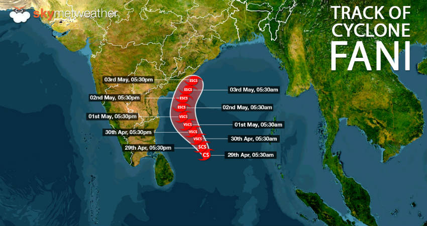
Cyclonic storm Fani is likely to become very severe cyclone in the next 24 hours and thereafter into an extremely severe cyclone in subsequent 24 hours. It would continue to move northwestwards.

Talking about rainfall over Indian mainland, Fani is still faraway in the sea and thus, we do not see any direct impact over the region. However, as the system gets more marked and comes closer, the periphery of Fani would start impacting the weather over South India including Kerala, Tamil Nadu, Andhra Pradesh and some parts of Karnataka.

Till then, majority of rains and high velocity winds would be mainly confined to sea only.

Image Credit: Kolkata24x7

Any information taken from here should be credited to skymetweather.com

[Hindi] कश्मीर, हिमाचल और उत्तराखंड में 30 अप्रैल से बारिश और बर्फ़बारी के आसार

उत्तर भारत की तरफ एक सक्रिय पश्चिमी विक्षोभ आ रहा है। यह सिस्टम इस समय उत्तरी पाकिस्तान और इससे सटे जम्मू-कश्मीर के पास पहुँच गया है। मौसम विशेषज्ञों की मानें तो इस मौसमी सिस्टम के कारण जम्मू-कश्मीर और हिमाचल प्रदेश के अधिकांश भागों पर कल यानि 30 अप्रैल से बारिश होने की संभावना है।

उत्तराखंड में भी यह पश्चिमी विक्षोभ बारिश दे सकता है। राज्य में 1 मई से बारिश वाले बादल आएंगे और कुछ स्थानों पर गरज के साथ बारिश की हल्की फुहारें देखने को मिलेंगी। इस दौरान जम्मू-कश्मीर, हिमाचल प्रदेश और उत्तराखंड के ऊंचे पहाड़ी हिस्सों पर हल्की बर्फ़बारी की संभावना से भी इंकार नहीं किया जा सकता। 

मौसम में इस बदलाव से जम्मू-कश्मीर, हिमाचल प्रदेश और उत्तराखंड में दिन के तापमान में 3 से 4 डिग्री की गिरावट देखने को मिल सकती है। जिससे इन राज्यों में अगले कुछ दिनों के दौरान मौसम थोड़ा ठंडक भरा होने के साथ-साथ सुहावना होने की उम्मीद है।

वैष्णो देवी सहित कटरा में भी गरज के साथ बारिश होने की संभावना है। इसके बावजूद इन तीनों राज्यों में भारी बारिश या बादल फटने की घटनाएं देखने को नहीं मिलेंगी।

संभावित मौसमी हलचल को देखते हुए इस बात की आशंका है कि कुछ रास्ते अवरुद्ध हो जाएंगे, जिससे पहाड़ों की ओर जाने वाले पर्यटकों को मुश्किलों का सामना करना पड़ सकता है। लेकिन इन मौसमी गतिविधियों के कारण भूस्खलन होने का खतरा नहीं है। ज़ाहिर है यातायात बड़े पैमाने पर प्रभावित नहीं होगा।

Also Read In English: KASHMIR, HIMACHAL AND UTTARAKHAND TO WITNESS RAIN AND SNOW BETWEEN APRIL 30 AND MAY 2

स्काइमेट के अनुसार, एक लम्बे अंतराल के बाद एक सक्रिय पश्चिमी विक्षोभ उत्तर भारत के पहाड़ी हिस्सों को प्रभावित करने वाला है। इस सिस्टम का बड़ा असर उत्तर भारत के मैदानी भागों में देखने को नहीं मिलेगा। हालांकि उत्तरी पंजाब और हरियाणा में कहीं-कहीं गरज के साथ हल्की बारिश की गतिविधियां देखने को मिल सकती हैं।

Image Credit: Scroll.in

कृपया ध्यान दें: स्काइमेट की वेबसाइट पर उपलब्ध किसी भी सूचना या लेख को प्रसारित या प्रकाशित करने पर साभार: skymetweather.com अवश्य लिखें।


Kashmir, Himachal and Uttarakhand to witness rain and snow between April 30 and May 2

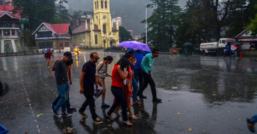
At present, a fresh Western Disturbance is seen over North Pakistan and adjoining parts of Jammu and Kashmir. In the wake of this weather system, rain and thundershower activities are likely to commence over parts of Jammu and Kashmir and Himachal Pradesh tomorrow onward.

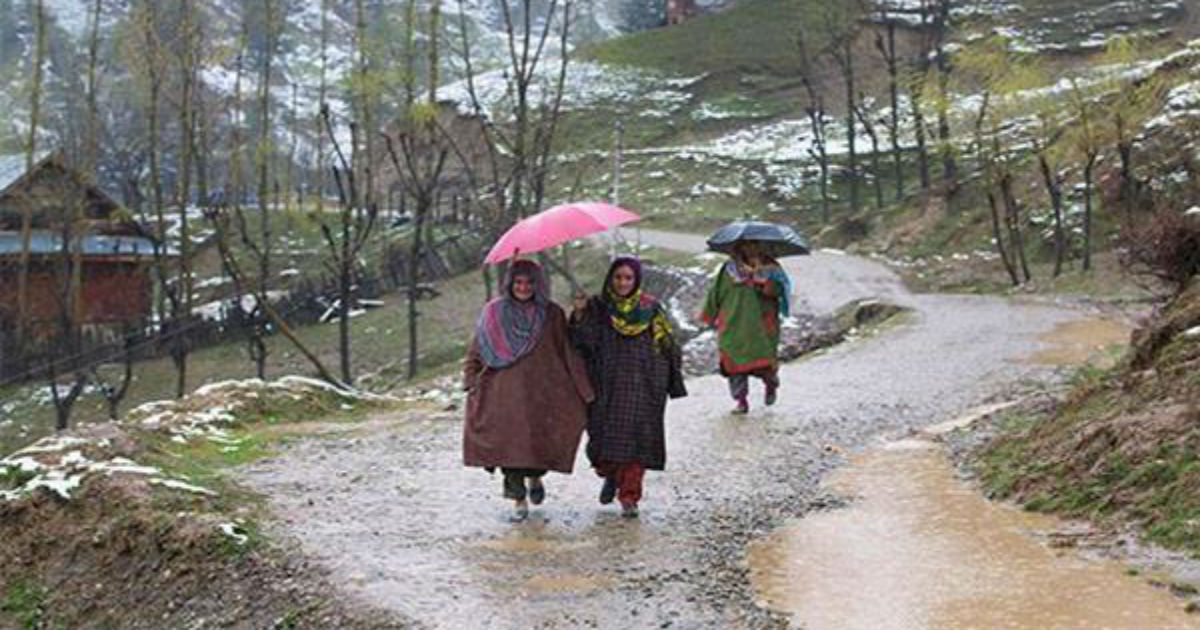
By May 1, parts of Uttarakhand will also start witnessing scattered rain and thundershowers. During this period, all the three hilly states may also observe snowfall activity over the higher reaches.

Thus, we can say that from April 30 to May 2, good spell of rain and thundershower activities along with isolated snowfall is expected over Jammu and Kashmir, Himachal Pradesh and Uttarakhand.

After a prolonged gap, an active Western Disturbance has affected the hills of North India but its effect on the plains of northern India will be minimal by being confined to thunderstorm or thundershower in isolated pockets of North Punjab and Haryana.

Vaishno Devi and Katra will also witness rain and thundershowers. Tourists travelling to the hills may face minor difficulties due to rain. But any chance of land slide or road blockage due to rain is completely ruled out.

Weather in Jammu and Kashmir, Himachal Pradesh and Uttarakhand during this spell of rain will become pleasant and cold as the day temperatures will drop by 3 to 4 degrees Celsius.

Image Credit: Pinterest

Please Note: Any information picked from here must be attributed to skymetweather.com

Heavy pre-Monsoon rains to lash Northeast India during the coming week, disruptions likely

Northeast India rains

The northeastern states of India i.e. Assam, Arunachal Pradesh, Meghalaya, Nagaland, Manipur, Mizoram and Tripura have been observing widespread rain and thundershower activities for the last two days.

In fact, cloudburst accompanied with hailstorm, heavy lightning and thunderstorm activity was recently reported in the Bomdila town in West Kameng district of Arunachal Pradesh.

At present, an anti-cyclone is over North Bay of Bengal which is feeding moisture to the northeastern states. A cyclonic circulation can also be seen persisting over Bangladesh and its adjoining area.

Both these weather systems are likely to act in tandem and give good rain in the region for the coming week.

By May 5 or 6, the remnants of cyclone Fani will reach Northeast India and during this time the intensity of rainfall will increase significantly. Heavy to very heavy spell of rain accompanied with violent lightning strikes and hailstorm will be observed in certain parts of the region.

Such widespread heavy rains will lead to disruption in terms of flash floods, landslides and road blockages over many parts of the northeastern states.

By May 7, the weather systems will move away from Northeast India giving way to clear conditions in the region.

Image Credit: Wikipedia

Please Note: Any information picked from here must be attributed to skymetweather.com

Weather Forecast April 29: Fani to become a Very Severe Cyclonic Strom, heat wave to intensify in Maharashtra, MP

Starting with South India where most of the weather activity seems to be concentrated right now! The Cyclonic Storm Fani has further intensified into a Severe Cyclonic Storm and is likely to become ‘Very Severe’ now. The system will continue to move in Northwest direction during the next 24 hours and would reach close to the Tamil Nadu coast. Thereafter, it is likely to recurve.

Fani is expected to skirt the Indian coast and thus, bringing strong gusty winds over Tamil Nadu coast, Gulf of Mannar and Comorin Area.

Apart from this, a trough is extending from Central India to Southeast Arabian Sea across Karnataka. This will bring rain and thundershower at a few places over South and Central Karnataka and adjoining North Kerala. Places like Bengaluru, Mangalore, Mysore, Kannur and Kozhikode will witness these rains.

Isolated rain and thunderstorm is also possible over North Andhra Pradesh coast.

However, dry and hot weather is likely over Telangana, Rayalaseema and most parts of Tamil Nadu including the cities of Chennai and Hyderabad.

Coming on to North India, here a fresh feeble Western Disturbance is likely to affect North Pakistan and adjoining Jammu and Kashmir. Also, a Cyclonic Circulation can be marked over Central parts of Pakistan and adjoining Rajasthan. These systems will bring rain and thundershower at some places over J&K and Himachal Pradesh. Also, isolated dust storm may make a round over West Punjab and North Rajasthan.

Heat wave will continue to pester over a few parts of Rajasthan.

Talking about East and Northeast India, a Cyclonic Circulation persists over Sub-Himalayan West Bengal. Also, a trough is extending from Northeast Bihar to Andhra Pradesh. This will bring light to moderate rain and thundershower over some places of Andhra Pradesh, Assam, Sub-Himalayan West Bengal and adjoining Sikkim. It might also rain at one or two places over Nagaland, Manipur, Mizoram, Tripura and Meghalaya.

Thunderstorms are likely at a few places over Gangetic West Bengal and Odisha.

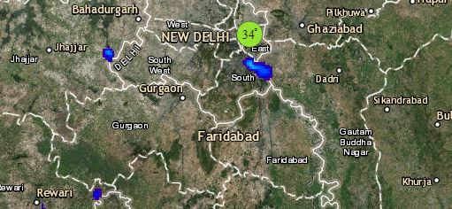
Click the image below to see the live lightning and thunderstorm across IndiaRain in India

Talking about Central India, where a mainly dry and hot weather is likely to continue. Heat wave will prevail over most parts of Madhya Pradesh, Vidarbha, Marathwada, and Gujarat. This will further cover parts of Chhattisgarh and Madhya Maharashtra as well. Cities like Nagpur, Bhopal, Ahmedabad and Ujjain might have to bear the brunt of this hot weather.

Any information taken from here should be credited to skymetweather.com


29 अप्रैल का मौसम पूर्वानुमान: तूफान फ़ानी हो सकता है अति भीषण, 30 अप्रैल पहुंचेगा चेन्नई के पास

शुरुआत दक्षिण भारत के मौसम से...... क्योंकि दक्षिण भारत सीज़न के पहले चक्रवात का जल्द कर सकता है सामना।
चक्रवाती तूफान फोनी भीषण चक्रवाती तूफान बन गया है। हमारा अनुमान है कि यह जल्द ही यह अति भीषण रूप ले लेगा। अगले 24 घंटों तक यह उत्तर-पश्चिमी दिशा में बढ़ेगा और तमिलनाडु के तटीय भागों के पास पहुँच जाएगा।
हालांकि चेन्नई के समानान्तर पहुँचने के बाद यह अपनी दिशा बदलेगा।

हालांकि भारत के पूर्वी तटों को बारिश के लिए 30 अप्रैल तक का इंतज़ार करना होगा।
इस बीच मध्य भारत से दक्षिण भारत तक एक ट्रफ बनी हुई है। इसके प्रभाव से कर्नाटक के दक्षिणी और मध्य भागों के साथ उत्तरी केरल में कुछ स्थानों पर बारिश हो सकती है।
उत्तरी तटीय आंध्र प्रदेश में भी एक-दो स्थानों पर वर्षा के आसार हैं।

रुख उत्तर भारत का करें तो यहाँ एक पश्चिमी विक्षोभ आने वाला है। साथ ही मध्य पाकिस्तान और इससे सटे राजस्थान पर एक चक्रवाती हवाओं का क्षेत्र विकसित हो गया है। इन सिस्टमों के कारण जम्मू कश्मीर में कुछ स्थानों पर और हिमाचल प्रदेश में कहीं-कहीं हल्की बारिश होगी।

पश्चिमी पंजाब और उत्तरी राजस्थान में एक-दो स्थानों पर धूलभरी आँधी चलने की संभावना है।
इसके बावजूद उत्तर भारत के ज़्यादातर शहरों में तापमान सामान्य से ऊपर बना रहेगा। राजस्थान के लगभग सभी इलाकों में लू का प्रकोप देखने को मिल सकता है। राजधानी दिल्ली में भी होगी भीषण गर्मी।

Click the image below to see the live lightning and thunderstorm across IndiaRain in India 

पूर्वी भारत में चलें तो यहाँ पश्चिम बंगाल पर एक चक्रवाती हवाओं का क्षेत्र बना हुआ है और एक ट्रफ रेखा भी सक्रिय है।
इसके चलते हिमालय से सटे पश्चिम बंगाल, सिक्किम, अरुणाचल प्रदेश और असम में कई जगहों पर हल्की से मध्यम बारिश देखने को मिल सकती है। जबकि नागालैंड, मणिपुर, मिज़ोरम, त्रिपुरा और मेघालय में एक-दो स्थानों पर बारिश होने की संभावना है।
ओड़ीशा, झारखंड, बिहार और पूर्वी उत्तर प्रदेश में मौसम शुष्क रहेगा। लू का सामना करना होगा।

मध्य भारत में सभी शहरों में मौसम शुष्क होगा। मध्य प्रदेश, छत्तीसगढ़, महाराष्ट्र और गुजरात में भोपाल, उज्जैन, नागपुर, अहमदाबाद सहित सभी शहरों पर कसेगा लू का शिकंजा।

Any information taken from here should be credited to skymetweather.com


Himachal, Jammu and Kashmir gear up for rains, Delhi, Punjab and Rajasthan to remain dry

A feeble Western Disturbance is likely to approach during the next 24 hours over North Himalayan region. Also, an induced Cyclonic Circulation would form over Central Pakistan and adjoining West Rajasthan in the lower levels. This disturbance may cause light rain and thundershower activities over some parts of Jammu and Kashmir and over a few pockets of East and Himachal Pradesh. Temperatures would drop over the region marginally. Night temperatures may rise, however.

Uttarakhand on the other hand will remain mainly dry. Marginal rise in temperatures is expected over the hilly areas.

Over the plains, Rajasthan will continue to remain the hottest belt, with a few places experiencing heat wave conditions (especially the western and northern parts).

Heat wave may develop in parts of Southwest Haryana and some parts of West Uttar Pradesh.

Isolated dust storm activity (mainly light) may occur in parts of West Punjab, and extreme North Rajasthan. Delhi will continue with very hot weather conditions. Morning will be comfortable with light dust and haze around. As the day progresses, it will be very hot and uneasy. Very light winds would prevail during the day.

Image Credits – wpnature.com 

Any information taken from here should be credited to Skymet Weather

[Hindi] पूर्वोत्तर भारत में जारी रहेगी बारिश, ओड़ीशा और पश्चिम बंगाल में भी 2 से 5 मई के बीच वर्षा के आसार

पूर्वोत्तर भारत और उप-हिमालयी पश्चिम बंगाल के अधिकांश भागों में बीते 24 घंटों के दौरान गरज के साथ मध्यम बारिश दर्ज की गई। इसके अलावा एक-दो स्थानों पर तेज़ बारिश भी देखने को मिली।

उपलब्ध आंकड़ों के अनुसार, पिछले 24 घंटों के दौरान असम के धुबरी में 39.7 मिलीमीटर, गोलाघाट में 11.6 मिलीमीटर, गुवाहाटी में 26.6 मिलीमीटर और मेघालय के चेरापूंजी में 25.2 मिलीमीटर बारिश दर्ज की गयी है।

मौसमी सिस्टम की बात करें तो पूर्वी उत्तर प्रदेश के ऊपर बनी ट्रफ अब उत्तर-पूर्वी बिहार से उप-हिमालयी पश्चिम बंगाल से होते हुए मणिपुर तक पहुँच गई है। इस ट्रफ के कारण अगले 24 घंटों के दौरान अरुणाचल प्रदेश, असम, मेघालय, नागालैंड, मणिपुर, मिजोरम, त्रिपुरा और उप हिमालयी पश्चिम बंगाल के अधिकांश इलाकों में बारिश की होने की संभावना है।

जबकि ओडिशा, गंगीय पश्चिम बंगाल, बिहार, झारखंड और पूर्वी उत्तर प्रदेश में आने वाले 24 से 48 घंटों के दौरान मौसम शुष्क रहेगा। दोनों राज्यों में कई स्थानों पर लू का प्रकोप भी देखने को मिल सकता है।

Also Read In English: ANOTHER RAINY DAY FOR NORTHEAST INDIA, RAINS TO COMMENCE OVER EAST INDIA FROM MAY 2

हालांकि 1 मई तक चक्रवाती तूफ़ान "फोनी" के कारण हवा की दिशा में बदलाव देखने को मिल सकता है। इस सिस्टम के ओडिशा के तटीय भाग की ओर बढ़ने के साथ ही ओडिशा और गंगीय पश्चिम बंगाल के अधिकांश इलाकों में आसमान में बादल बढ़ जाएंगे और बारिश 2 मई से शुरू हो सकती है।

मौसम विशेषज्ञों के अनुसार, 2 से 5 मई के दौरान गोपालपुर, पुरी, भुवनेश्वर, बालासोर, बारीपदा, मेदिनीपुर, कोलकाता और 24 परगना जैसे स्थानों पर तेज़ हवाओं और गरज के साथ बारिश होने की उम्मीद है।

दूसरी ओर रांची, जमशेदपुर, धनबाद, पटना, गया, वाराणसी, प्रयागराज, मिर्ज़ापुर सहित झारखंड, बिहार और पूर्वी उत्तर प्रदेश में तूफान फ़ानी बारिश नहीं देने वाला। इन भागों में इस सप्ताह मौसम शुष्क ही बना रहेगा।

Image Credit: South Asia Views

कृपया ध्यान दें: स्काइमेट की वेबसाइट पर उपलब्ध किसी भी सूचना या लेख को प्रसारित या प्रकाशित करने पर साभार: skymetweather.com अवश्य लिखें।

IPL 2019: Kolkata Knight Riders vs Mumbai Indians clash to take place amidst hot and humid weather in Kolkata

mi vs kkr

The 47th match of the 12th season of IPL will be between Kolkata Knight Riders and Mumbai Indians today. This match will begin from 08:00 at Eden Gardens in Kolkata.

Fans have great hopes from the Kolkata team playing in their home ground today. At the same time, Mumbai Indians will do their best to win the battle. It will be interesting to see Kolkata breaking the monotony of its defeat today.

Weather of Kolkata during the match

During the match today, Kolkata's weather is expected to be very hot and humid. There is a possibility of 75 to 80% moisture in the weather. Also the temperature is likely to remain between 30℃ and 31℃.

Apart from this, winds will continue to blow at a speed of 15 to 20 kmph. Due to these winds, the players and the audience will get a slight relief from the heat.

Also read: आईपीएल 2019: कोलकाता में नाइट राइडर्स और मुंबई इंडियंस के मुक़ाबले में गर्मी और उमस भी होंगे प्रतिद्वंदी

IPL statistics

Both the teams have played 23 matches against each other in IPL so far, 18 won by Mumbai Indians while 5 by Knight Riders. Of these 9 matches were played in Mumbai, 7 of them won by Mumbai and 2 matches by Kolkata. Out of 9 matches played in Kolkata, Mumbai got victory over 8 matches, while Kolkata managed to register only 1 victory.

In the beginning of this season, Kolkata had performed well. However, they had to face defeat in the last 5 matches.

The Kolkata team has managed to register victory over just 4 out of 11 matches played in this season. The team stands at the seventh position on the points table.

The scenario is completely opposite for Mumbai Indians. The team has won 7 out of 11 matches this season, standing second on points table.

It will be interesting to see if Kolkata Knight Riders wins over Mumbai Indians today.

Image Credits – Pinterest

Any information taken from here should be credited to Skymet Weather

[Hindi] आईपीएल 2019: कोलकाता में नाइट राइडर्स और मुंबई इंडियंस के मुक़ाबले में गर्मी और उमस भी होंगे प्रतिद्वंदी

आईपीएल के 12वें सीज़न का 47वां मैच आज कोलकाता में खेला जाएगा। रविवार का यह दूसरा मैच कोलकाता नाइट राइडर्स और मुंबई इंडियंस के बीच रात 08:00 बजे से इडेन गार्डन मैदान पर होगा।

अपने घरेलू मैदान में खेल रही कोलकाता की टीम से फैंस को काफी उम्मीदें रहेंगी। वहीं मुंबई इंडियंस अपनी हार को दोहराने से बचने की पूरी कोशिश करेगी।

मैच के समय कोलकाता का मौसम

आज मैच के दौरान कोलकाता का मौसम बहुत गर्म और उमसभरा होगा। जब खेल शुरू होगा उस समय दिन का तापमान भले ही घटकर 31 और 30 डिग्री के आसपास आ जाएगा लेकिन खिलाड़ियों और दर्शकों को राहत नहीं मिलेगी क्योंकि आर्द्रता 75 से 80 प्रतिशत के स्तर पर बनी रहेगी। इसके चलते गर्मी का फील फ़ैक्टर 35 डिग्री का होगा

इसमें थोड़ी राहत इसलिए मिल सकती है क्योंकि हवा काफी तेज़ होगी। मौसमी विशेषज्ञों के अनुसार कोलकाता में रात 8 बजे भी 15 से 20 किमी प्रतिघंटे की रफ्तार से हवाएं चलेंगी। हवा के कारण खिलाडियों और दर्शकों को कुछ सुकून मिल सकता है।

बात आंकड़ों की

आईपीएल में अब तक मुंबई इंडियंस और कोलकाता नाईट राइडर्स के बीच 23 मुक़ाबले हुए हैं। जिनमे से 18 मैच मुंबई इंडियंस ने अपने नाम किये वहीं नाईट राइडर्स को 5 बार जीत मिली। इनमे से 9 मुक़ाबले मुंबई में हुए जिनमे से 7 मैच मुंबई ने जीते और 2 मैच कोलकाता ने जीते। और कोलकाता में हुए 9 में से 8 मैच मुंबई ने जीते और कोलकाता को सिर्फ 1 मैच में सफलता मिली। इन आंकड़ों के हिसाब से मुंबई का पलड़ा भारी दिख रहा है।

इस सीज़न की शुरुआत में कोलकाता ने अच्छा प्रदर्शन किया था लेकिन फिर उनके पैर लड़खड़ा गए और पिछले 5 मैचों से लगातार हार का सामना करना पड़ा है। कोलकाता की टीम इस सीज़न में खेले गए अपने 11 में 4 जीत ही दर्ज कर पायी है। जिसके कारण वह अंकतालिका में सातवें स्थान पर है।

वहीं मुंबई इंडियंस इसके बिलकुल उलट है। मुंबई इंडियंस इस सीज़न में 11 में से 7 मैच जीत कर अंकतलिका में दूसरे स्थान पर है।

ऐसे में यह देखना दिलचस्प रहेगा कि क्या कोलकाता नाईट राइडर्स अपनी हार का सिलसिला तोड़ पाती है या फिर आंकड़ों के मुताबिक मुंबई जीत अपने नाम करती है।

Image Credit: deccanchronicle.com

कृपया ध्यान दें: स्काइमेट की वेबसाइट पर उपलब्ध किसी भी सूचना या लेख को प्रसारित या प्रकाशित करने पर साभार: skymetweather.com अवश्य लिखें।


latest news