
Skymet weather

Cyclone Fani Latest News And Update: Fani to give rains in parts of West Bengal, Death toll rises to 16

Cyclone Fani update

Updated on May 5, 2019 1:45 PM: Rains in parts of West Bengal, Kolkata to remain dry

Even after weakening, cyclone Fani managed to give light to moderate rain and thundershower activities over parts of West Bengal during the last 24 hours. Berhampore recorded 11 mm of rain, followed by Darjeeling 7 mm, Kalaikunda 4.1 mm, Jalpaiguri 3.7 mm and Malda 3.4 mm, till yesterday. Weather in Kolkata remained almost dry with partly cloudy to cloudy sky conditions. The maximum temperature recorded by the city was 29.1˚C, which was 6 degrees below normal. Mainly dry weather conditions will prevail and as time progresses Gangetic West Bengal will start observing hot weather conditions. Moreover, as clouding will decrease, day temperatures over most parts of West Bengal including Kolkata will rise rapidly.

Read in detail: Light rains in parts of West Bengal, Kolkata to remain dry

Updated on May 5, 2019 12:30 PM: Death toll rises to 16, restoration work begins

According to media reports, the death toll due to Cyclone Fani in Odisha has gone up to 16. The toll that stood at 9 on Friday, climbed to 16 yesterday. Four deaths were reported from Mayurbhanj district alone, while 3 each were reported from Puri, Bhubaneswar and Jajpur. One each from Keonjhargarh, Nayagarh and Kendrapara.

Read in detail: Death toll rises to 16, restoration work begins

Updated on May 5, 2019 12:15 PM: Fani to give widespread rains over the northeastern states of India

In the wake of cyclone Fani, the northeastern states of India i.e. Assam, Arunachal Pradesh, Meghalaya, Manipur, Mizoram, Tripura and Nagaland witnessed heavy to very heavy rainfall activity accompanied with strong winds during the last 24 hours.

Such widespread weather activities occurred due to northeastward movement of cyclonic storm Fani.

This weather system would be moving further eastwards and becoming insignificant for the northeastern states of India after the next 6 to 12 hours. In fact, as the system is moving away, weather conditions will also start improving in Northeast India.

Read in detail: Fani to give widespread rains over the northeastern states of India

Updated on May 4, 2019 6:00 PM: Cyclone Fani weakens into Deep Depression

The Cyclone Storm Fani has weakened into Deep Depression and is likely to weaken gradually and would move further northeastwards. Due to movement of Cyclone Fani, most parts of Odisha have witnessed extreme bad weather conditions mainly over the coast and northern parts of the Odisha. Cyclone Fani has also affected most parts of West Bengal with slashing winds reaching up to 90 kmph and heavy to very heavy rains in some parts.

Updated on May 4, 2019 4:00 PM: Temperatures drop in Bihar and Jharkhand due to Cyclone Fani

Due to Cyclone Fani, most parts of South Jharkhand experienced heavy to very heavy rains with very strong winds/squalls reaching 60-70 kmph. While, some parts of East and South Bihar, rest of Jharkhand witnessed light to moderate rain and thundershowers. In the last 24 hours, from 8:30 am on Friday Farbesganj, Purnia, Bhagalpur and Chapra witnessed 33.4 mm, 15.1 mm, 31.8 mm and 13.4 mm of rains, respectively.

While in Jharkhand, Jamshedpur witnessed the day temperature settling at 27.2°C, which is a drop of almost 12 degrees. It also recorded 64.2 mm of good rain.

May 5 onward, most parts of Bihar would see normal pattern of wind flow. Hence, gradual rise in temperatures are expected. Jharkhand would see dry weather conditions with rise in temperature from today itself.

Read in detail: Temperatures drop in Bihar and Jharkhand due to Cyclone Fani

Updated on May 4, 2019 2:00 PM: After Fani disrupts life in Odisha, dry weather ahead for the state

After being hit by the Extremely Severe Cyclone Fani and facing a huge loss to life and property, the coastal state of Odisha is now going to experience some relief in terms of weather.

Currently, the intensity of the storm has reduced significantly as it has moved away in an eastward direction. Presently, the Cyclonic Storm is lying over Northwest Bangladesh as a Deep Depression.

South Odisha will witness mainly dry weather condition. A significant rise in the day temperatures will be witnessed. However, in North Odisha the weather will remain partly cloudy, with chances of light rains over few places.

Over the next 24 hours, normal pattern of winds are likely to blow which will gradually lead to rise in temperatures and humid weather along the coastal stations.

Read in detail: After Fani disrupts life in Odisha, dry weather ahead for the state

Updated on May 4, 2019 1:00 PM: Torrential rains to hit Cooch Behar, Jalpaiguri and Siliguri in the wake of Cyclone Fani

In the past 24 hours, heavy to extremely heavy rains have occurred over many parts of Gangetic West Bengal especially over Bankura, Purulia and Alipore. Malda too witnessed moderate to heavy rain and thundershowers. The Severe Cyclonic Storm Fani over Gangetic West Bengal moved further north-northeastwards with a speed of about 29 kmph in last six hours and gradually weakening into a Cyclonic Storm.

As per the experts, the intensity of rains would increase over the central districts and as well as over Sub Himalayan West Bengal and Sikkim. Places like Burdhman, Malda, North Dinajpur, South Dinajpur, Cooch Behar, Jalpaiguri, Siliguri would receive moderate to heavy rains. With time, the intensity is expected to reduce over Gangetic West Bengal but for next 24 hours, fairly widespread rain and thundershowers would continue. Thereafter, the system will move further towards Northeast India due to which the intensity of rain will reduce in the region.

Read in detail: Torrential rains to hit Cooch Behar, Jalpaiguri and Siliguri in the wake of Cyclone Fani

Updated on May 4, 2019 11:00 AM: After wreaking havoc in India, Cyclone Fani to make an arrival in Bangladesh

After making landfall in India Friday morning, Cyclone Fani is now headed in the east-northeast direction towards Bangladesh and is likely to hit the coastal country of Bangladesh today. However, by this time, the system would have weakened further due to lack of enough moisture content.

Already, necessary control rooms have been opened in 19 coastal districts of the country.

People living in the coastal areas where Cyclone Fani is going to impact have been asked to remain watchful. A total of 56,000 volunteers have been kept on hold.

Read in detail: After wreaking havoc in India, Cyclone Fani to make an arrival in Bangladesh

Updated on May 3, 2019 5:00 PM: Cyclone Fani wreaks havoc in Odisha and its adjoining areas

Several coastal areas of Odisha including parts of north coastal Andhra Pradesh received heavy rainfall at the time of Cyclone Fani making landfall. Severe inundation was reported from several areas in the region.

Strong winds associated with Cyclone Fani lead to uprooting of trees, electricity poles, hoardings and ransacking window panes. Thatched structures were destroyed completely at some places including the capital Bhubaneswar.

Read in detail: Cyclone Fani to trigger heavy rains and strong winds in Bihar and Jharkhand today

Updated on May 3, 2019 3:00 PM: After Odisha, West Bengal gears up for very heavy rains and stormy weather

It has already started raining heavily in South Bengal. Places like Digha, Diamond Harbour and Kolkata are already under the influence of storm Fani. The wind speed at present is 25 kmph.

Places like Bankura, Purulia, Jhargaon, Midnapore, Hugli, Howrah, Kolkata and 24 Parganas will be the majorly affected districts in West Bengal in wake of Cyclone Fani.

Read in detail: After Odisha, West Bengal gears up for very heavy rains and stormy weather

Updated on May 3, 2019 2:00 PM: Cyclone Fani, the most powerful storm in India after Super Cyclone in 1999

Cyclone Fani is now the strongest cyclonic storm since the Super Cyclone that had struck India in 1999. It had also made landfall at Puri that had claimed about 10,000 lives.

The cyclone is likely to affect around 10,000 villages and more than 50 towns in its path. More than 140 trains have been cancelled so far keeping in view the cyclone’s trail. All flights from Bhubaneswar had been cancelled since yesterday midnight.

Read in detail: Cyclone Fani, the most powerful storm in India after Super Cyclone in 1999

Updated on May 3, 2019 9:30 AM: Cyclone Fani makes landfall in Puri, wind speed reaching 200 kmph

As expected, Cyclone Fani has made landfall at Puri, Odisha at 8:40 am on Friday. The eye of the storm has entered the land mass, triggering torrential rains and damaging winds.

At present, wind speed is around 180-190 kmph gusting up to 200-220 kmph. It would be almost two hours long process, as the system passes through land. Since the system would be now travelling inland, it also expected to weaken.

Read in detail: Cyclone Fani makes landfall in Puri, wind speed reaching 200 kmph

Updated on May 2, 2019 6:45 PM: Checkout the districts on alert in Andhra Pradesh, Odisha, West Bengal

Since cyclone Fani is travelling very close to the coast, we can now expect heavy to extremely heavy rains across Andhra Pradesh, Odisha and West Bengal from May 2-4 in a similar order. Andhra Pradesh has already started reporting heavy rains in the coastal areas.

Around 8 Lakhs have been evacuated so far and several trains are either cancelled or rerouted.

Following is the list of the districts which are likely on the bigger risk across these three states as Extremely Severe Cyclonic Storm Fani prepares to cross the coast:
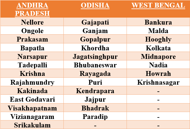
Districts on alert

Read in detail: Cyclone Fani: Checkout the districts on alert in Andhra Pradesh, Odisha, West Bengal

Updated on May 2, 2019 1:00 PM: Extremely severe cyclone Fani Set to hit Puri on May 3, Odisha evacuates people

In Odisha, Andhra Pradesh and West Bengal at least 19 districts are expected to get affected by the extremely severe cyclonic storm Fani, which is likely to cross Odisha Coast between Gopalpur and Chandbali, around Puri during May 3 afternoon.

The cyclone will pass through Jagatsinghpur, Kendrapara, Bhadrak and Balasore in Odisha before reaching West Bengal with a maximum sustained wind speed of 170-180 kmph gusting to 200 kmph.

The government of Odisha has set up 900 cyclone shelters to house the evacuees and has requested for two helicopters to be stationed in the state for emergency food distribution.

In addition to this, troops of the Indian Navy and the Indian Coast Guard as well as 78 teams of the National Disaster Response Force (NDRF) have been requested for deployment as well. The country's top body to handle an emergency situation, NCMC has also reviewed the preparations for Fani.

The NDRF has deployed 12 teams in Andhra Pradesh, 28 in Odisha and 6 in West Bengal. Additionally, 32 teams remain on standby, equipped with boats, tree cutters and telecom equipment.

Read in detail: Extremely severe cyclone Fani Set to hit Puri on May 3, Odisha evacuates people

Updated on May 2, 2019 11:10 AM: 103 trains cancelled, 2 diverted in wake of Cyclone Fani

In wake of the Cyclone Fani, a total of 103 trains have been cancelled while 2 have been diverted.

According to the sources, the whole section between Bhadrak-Bhubaneswar-Puri-Visakhapatnam will be cleared so that there will be no train in the section during the extreme situation, keeping in view the safety of trains and passengers amidst the arising storm.

The decision comes in the wake of the upcoming Cyclone Fani that is about to wreak havoc over the eastern coastline affecting Odisha and Andhra Pradesh most of all.

Cyclone Fani is likely to affect a total of 19 districts in the states of Odisha, Andhra Pradesh and West Bengal. State and national authorities have already put Odisha on alert against inclement weather conditions, particularly in 12 districts of Ganjam, Gajapati, Gopalpur, Khurda, Bhubaneswar, Puri, Jagatsinghpur, Rayagada, Kendrapara, Bhadrak, Jajpur, Paradip and Balasore.

Read in detail: 103 trains cancelled, 2 diverted in wake of Cyclone Fani

Updated on May 1, 2019 7:00 PM: Extremely Severe Cyclone Fani to bring very heavy rains in Odisha, Andhra Pradesh, sea conditions to be very rough

At present, the extremely severe cyclone Fani is seen over North Coastal Andhra Pradesh and adjoining Odisha Coast. Therefore, we expect heavy to very heavy rains over north coastal parts of Andhra Pradesh and South Coastal Odisha. Isolated places may even witness extremely heavy rains. Sea conditions will be rough to very rough. Strong winds of 100 to 150 kmph gusting up 180 kmph are possible.

Rains in South India will reduce. However, scattered rains are expected over South Coastal Andhra Pradesh, South Karnataka, Interior Tamil Nadu and Kerala. The weather of Telangana and Rayalaseema will remain cloudy with chances of light rain in few parts.

Read in detail: Extremely Severe Cyclone Fani to bring very heavy rains in Odisha, Andhra Pradesh, sea conditions to be very rough

Updated on May 1, 2019 4:00 PM: Extremely Severe Cyclone Fani to give rains in Bengaluru, Karnataka today, weather to go dry by May 2

The state of Karnataka has been observing dry weather conditions from the last many days. however, during the last 24 hours, scattered light to moderate rain and thundershower activity was witnessed in parts of Karnataka including Bengaluru. All thanks to the extremely severe cyclone Fani in West Central and adjoining southwest Bay of Bengal.

In the last 24 hours from 08:30 am on Tuesday, Sampangiramnagar in Bengaluru recorded 152 mm of rain.

Read in detail: Extremely Severe Cyclone Fani to give rains in Bengaluru, Karnataka today, weather to go dry by May 2

Read in detail: 10 Latest Developments on Extremely Severe Cyclone Fani

Updated on April 30, 2019 6:45 PM: Torrential rains alert for Andhra Pradesh on May 2 as Very Severe Cyclone Fani nears the coast

Very severe cyclonic storm Fani is brewing over Southwest and adjoining Southeast Bay of Bengal, moving north-northwest towards the Indian coast.

Though Andhra Pradesh is not directly in the firing range of Fani, but would have to brave heavy rains and some inclement weather conditions in the coming days.

The system would travelling parallel to the Indian coast but would maintain a fair distance from the coast. The rains would commence over parts of Andhra Pradesh on May 1. Wind speed would also start increasing, in order of 60 kmph -70 kmph, gusting 80 kmph-90 kmph.

By May 2, very severe cyclone Fani would have moved north and would be near north coastal Andhra Pradesh. During this time, we expect heavy to extremely heavy rains in north coastal Andhra Pradesh, places like Srikakulam, Visakhapatnam, Vizianagaram and Kakinada will be a sight to the same. Meanwhile, light to moderate rainfall are likely over south coastal Andhra Pradesh. Damaging winds to the tune of 80 kmph-90 kmph, gusting up to 100 kmph-120 kmph would be seen all along the coast.

Read in detail: Torrential rains alert for Andhra Pradesh on May 2 as Very Severe Cyclone Fani nears the coast

Updated on April 29, 2019 1:30 PM: Heavy rains and strong winds to lash Sri Lanka, advisory issued

Cyclone Fani at present is located nearly 600 km east of Trincomalee, Sri Lanka. In fact, the system has already started controlling the weather over Sri Lanka that has been witnessing light to moderate rain and thundershowers since yesterday. Till now, Katunayake has recorded extremely heavy rains to the tune of 111.8 mm. This was followed by Galle that has received 19 mm of rains, Monaragala 4.7mm, Ratnapura 4.5 mm, Anuradhapura 3.3 mm, Kurunegala 3 mm and Katugastota 12 mm.

Read in detail: Cyclone Fani: Heavy rains and strong winds to lash Sri Lanka, advisory issued

IPL 2019: Humid Mumbai to host do or die clash between MI and KKR

MI v KKRThe Indian Premier League will have its last match played before the playoffs begin and only four teams will be able to reach to the top. CSK and DC have already qualified and CSK seems to be having a major advantage if they end up winning today’s game as well.

Today, two games will be played. The first is between the KXIP and the CSK in Mohali while the other which we will be talking about is a clash between MI and KKR and will be the decider as to whether KKR will be able to reach the playoffs or not.

Weather wise, temperatures in Mumbai will settle between 28 and 29 degrees Celsius. In fact, dry weather in Mumbai will continue and rainfall activity will not be seen. On the other hand, humidity will continue to be between 75 to 85 percent which may cause some discomfort to the players.

Team wise, Mumbai Indians have already qualified to the playoffs and if they do win this one, there will be heading towards an advantage in the game. Meanwhile, if KKR lose this game, their one chance of reaching the playoffs will be taken away by the Mumbai Indians. It will be interesting to see who bends the knee.

Image Credit:


Cyclone Fani Live Update: Rains in parts of West Bengal, Kolkata to remain dry

Cyclone Fani live update

Updated on May 5, 2019 1:20 PM: Fani to give light rains in parts of West Bengal, Kolkata to remain dry

Even after weakening, cyclone Fani managed to give light to moderate rain and thundershower activities accompanied with strong winds over parts of West Bengal during the last 24 hours. In the last 24 hours from 08:30 am on Saturday, Berhampore recorded 11 mm of rain, followed by Darjeeling 7 mm, Kalaikunda 4.1 mm, Jalpaiguri 3.7 mm and Malda 3.4 mm. All these weather conditions occurred in association with cyclone Fani’s northeastwards movement. However, weather in Kolkata remained almost dry with partly cloudy to cloudy sky conditions. The maximum temperature recorded by the city was 29.1˚C, which was 6 degrees below normal. The minimum temperature was also 2 degree below normal at 24.2˚C.

Updated on May 5, 2019 11:55 AM: Fani to give widespread rains over the northeastern India

In the wake of cyclone Fani, the northeastern states of India i.e. Assam, Arunachal Pradesh, Meghalaya, Manipur, Mizoram, Tripura and Nagaland witnessed heavy to very heavy rainfall activity accompanied with strong winds during the last 24 hours.

In the last 24 hours from 08:30 am on Saturday, Cherrapunji recorded 276 mm of rain, followed by Shillong 127 mm, Barapani 88 mm, Guwahati 83 mm, Tezpur 58 mm, Goalpara 52 mm, Mazbat 51 mm, North Lakhimpur 49 mm, Pet Jorhat 38 mm, Dhubri 30 mm, Silchar 29 mm, Dibrugarh 28 mm, Kohima 26 mm, Kailashahar and Lumding 25 mm.

Such widespread weather activities occurred due to northeastward movement of cyclonic storm Fani. At present, the same system has weakened into a low-pressure area and lies over eastern parts of Nagaland, Upper Assam, Arunachal Pradesh and adjoining North Myanmar.

This weather system would be moving further eastwards and becoming insignificant for the northeastern states of India after the next 6 to 12 hours. In fact, as the system is moving away, weather conditions will also start improving in Northeast India.

Updated on May 5, 2019 10:00 AM: Cyclone Fani weakens into a trough

The Depression over Bangladesh has become insignificant and now lies as an upper air trough from Arunachal Pradesh to North Bengal. The rain intensity is expected to decrease significantly over the northeastern states. However, light to moderate rains would continue over Arunachal Pradesh, Assam and Meghalaya. While, light rains would be a sight over rest of the northeastern states and Sub Himalayan West Bengal and Sikkim with light to moderate winds tagged along. Isolated thunderstorm and rain is a possibility over Coastal parts of Odisha. Odisha too would witness rise in temperature.

Updated on May 4, 2019 7:00 PM: Temperatures drop in Bihar and Jharkhand due to Cyclone Fani

Due to Cyclone Fani, last night most parts of South Jharkhand experienced heavy to very heavy rains with very strong winds/squalls reaching 60-70 kmph. While, some parts of East and South Bihar, rest of Jharkhand witnessed light to moderate rain and thundershowers. In the last 24 hours, from 8:30 am on Friday Farbesganj, Purnia, Bhagalpur and Chapra witnessed 33.4 mm, 15.1 mm, 31.8 mm and 13.4 mm of rains, respectively.

While in Jharkhand, Jamshedpur witnessed the day temperature settling at 27.2°C, which is a drop of almost 12 degrees. It also recorded 64.2 mm of good rain.

May 5 onward, most parts of Bihar would see normal pattern of wind flow. Hence, gradual rise in temperatures are expected. Jharkhand would see dry weather conditions with rise in temperature from today itself. There is possibility of light thunderstorm activity on May 5 due to the remnants of Cyclone Fani.

Updated on May 4, 2019 5:00 PM: After Fani disrupts life in Odisha, dry weather ahead for the state

After being hit by the Extremely Severe Cyclone Fani and facing a huge loss to life and property, the coastal state of Odisha is now going to experience some relief in terms of weather.

Currently, the intensity of the storm has reduced significantly as it has moved away in an eastward direction. Presently, the Cyclonic Storm is lying over Northwest Bangladesh as a Deep Depression.

South Odisha will witness mainly dry weather condition. In North Odisha the weather will remain partly cloudy, with chances of light rains over few places.

Over the next 24 hours, normal pattern of winds are likely to blow which will gradually lead to rise in temperatures and humid weather along the coastal stations.

Updated on May 4, 2019 2:00 PM: Torrential rains to hit Cooch Behar, Jalpaiguri and Siliguri in the wake of Cyclone Fani

In the past 24 hours, heavy to extremely heavy rains have occurred over many parts of Gangetic West Bengal especially over Bankura, Purulia and Alipore. The Severe Cyclonic Storm Fani over Gangetic West Bengal moved further north-northeastwards with a speed of about 29 kmph in last six hours and gradually weakening into a Cyclonic Storm.

As per the experts, the intensity of rains would increase over the central districts and as well as over Sub Himalayan West Bengal and Sikkim. Places like Burdhman, Malda, North Dinajpur, South Dinajpur, Cooch Behar, Jalpaiguri, Siliguri would receive moderate to heavy rains. With time, the intensity is expected to reduce over Gangetic West Bengal but for next 24 hours, fairly widespread rain and thundershowers would continue.

Updated on May 4, 2019 11:00 AM: After wreaking havoc in India, Cyclone Fani to make an arrival in Bangladesh

After making landfall in India Friday morning, Cyclone Fani is now headed in the east-northeast direction towards Bangladesh and is likely to hit the coastal country of Bangladesh today. However, by this time, the system would have weakened further due to lack of enough moisture content.

Already, necessary control rooms have been opened in 19 coastal districts of the country.

People living in the coastal areas where Cyclone Fani is going to impact have been asked to remain watchful. A total of 56,000 volunteers have been kept on hold.

Updated on May 3, 2019 7:30 PM: Cyclone Fani: Kolkata, West Bengal witness heavy rain with squally winds

Due to the land interaction, now the intensity of Cyclone Fani would eventually keep weakening because the moisture feed from the sea has now reduced drastically. This system is expected to keep moving in northeast direction along the coastal districts of Odisha.

It has already started raining heavily in South Bengal. Places like Digha, Diamond Harbour and Kolkata are already under the influence of storm Fani. The wind speed at present is 25 kmph.

Places like Bankura, Purulia, Jhargaon, Midnapore, Hugli, Howrah, Kolkata and 24 Parganas will be the majorly affected districts in West Bengal in wake of Cyclone Fani.

Updated on May 3, 2019 11:30 AM: Cyclone Fani hits Puri: One dead in Puri, Millions of people evacuated

As Cyclone Fani made landfall over Puri near Odisha Coast, One person died due to the uprooting of trees in Sakhigopal area in Puri and some houses got damaged due to strong winds and heavy rain . Over 1 Million peopless have been shifted to temporary shelters in Odisha as the most severe Cyclone Fani has made landafall over Puri, Odisha.

Updated on May 3, 2019 9: 10 AM: Cyclone Fani hits Puri, Odisha, triggers torrential rains, winds over 200 kmph

Cyclone Fani makes landfall at Puri near Odisha Coast. The eye of the storm has entered the land mass, triggering torrential rains and damaging winds. Presently, winds speed is around 180-190 kmph gusting up to 200-220 kmph. It will almost last for two hours, as the system passes through the land. System is expected to weaken, as it is now travelling inland.

Updated on May 3, 2019 8:30 AM: Cyclone Fani to cross Puri, Odisha anytime

Cyclone Fani is all set to make landfall at Puri coast in Odisha any time now. Fani is about 40 km far away from the coast.Extremely heavy rains with squally winds have already started lashing the coastal parts of Odisha.

Next two to three hours will remain very crucial for Odisha, due to extreme weather conditions in terms of torrential rains, damaging winds, flooding uprooting of trees, snapping of communication and electricity poles.

Updated on May 2, 2019 7:30 PM: Cyclone Fani to make landfall near Puri, Heavy rain in Odisha, West Bengal and Andhra Pradesh

Cyclone Fani is expected to cross Odisha Coast by or before forenoon of May 3. Just before striking the coast, it would weaken slightly and make landfall as a very severe cyclonic storm near Puri.

Therefore, we expect extremely heavy rains over Coastal Odisha. Light to moderate are likely over North Coastal Andhra Pradesh and rest of Odisha. By late afternoon, rain belt will cover Gangetic West Bengal, many parts of Jharkhand and East Bihar. These areas will also witness moderate to heavy rains.

However, rains will reduce over Arunachal Pradesh, East Assam, Nagaland and Manipur. While, Meghalaya, Tripura and West Assam will receive good rains.

Updated on May 2, 2019 11:10 AM: In the wake of Cyclone Fani 103 Trains got cancelled, 2 got diverted

As Cyclone Fani is nearing over Odisha and Andhra Pradesh coasts, a total of 103 trains have been cancelled while 2 have been diverted. Some of the major trains which have been cancelled include Howrah-Chennai Central Coromandal Express, Patna-Eranakulam Express, New Delhi-Bhubaneswar Rajdhani Express, Howrah-Hyderabad East Coast Express, and Bhubaneswar-Rameswaram Express.

Cyclone Fani is likely to affect a total of 19 districts in the states of Odisha, Andhra Pradesh and West Bengal. State and national authorities have already put Odisha on alert against inclement weather conditions, particularly in 12 districts of Ganjam, Gajapati, Gopalpur, Khurda, Bhubaneswar, Puri, Jagatsinghpur, Rayagada, Kendrapara, Bhadrak, Jajpur, Paradip and Balasore.

Updated on May 1, 2019 7:00 PM: Cyclone Fani to bring very heavy rains over Odisha, Andhra Pradesh, Sea conditions will be rough to very rough
At present, the extremely severe cyclone Fani is nearing North Coastal Andhra Pradesh and adjoining Odisha Coast. Therefore, parts of Andhra Pradesh and Odisha is expected to witness heavy to extremely heavy rains. Sea conditions will be rough to very rough.

Updated on May 1, 2019 6:30 PM:As Cyclone Fani will cross West Bengal, Heavy rains will be witnessed by the states on May 3-4
With Extremely Severe Cyclone Fani gearing up for landfall at Odisha coast, West Bengal has also started bracing up for facing the brunt. By that time cyclone Fani would reach West Bengal, it would have weakened into a cyclonic storm only.

Intensity of Rain will be on lower side on May 2. By May 3 states of West Bengal such as Medinipur, 24 South Parganas, Kolkata, Howrah, Bankura, Hooghly and Bardhaman is expected to witness heavy to very heavy rains.

Updated On May 1, 2019 5:30 PM: Extremely Severe Cyclone Fani to hit Puri on May 3, Heavy rains, damaging winds are expected
The Extremely Severe Cyclone Fani is gradually coming closer to the coast and is all set to make landfall over the Odisha coast on May 3. Cyclone Fani is expected to cross Odisha coast near Satpada and Balukhand area in Puri district around afternoon of May 3.

Odisha is now gearing up for heavy to extremely heavy rains accompanied with damaging winds during the during next 2 days. State and national authorities have put Odisha on alert against weather conditions, particularly in the following districts of Ganjam, Gajapati, Gopalpur, Khurda, Bhubaneswar, Puri, Jagatsinghpur, Rayagada, Kendrapara, Bhadrak, Jajpur, Paradip and Balasore.

Updated On May 1, 2019 3:00 PM: Extremely Severe cyclone Fani to effect Northeast states, heavy rains, strong winds are expected by May 5

The northeastern states have been witnessing moderate to heavy rains since the last three to four days. A Cyclonic Circulation is persisting over Assam and adjoining areas. Thus, rains have increased over the areas and good rains would continue till May 2. Thereafter, there can be a slight dip in the intensity of rains as Extremely Severe Cyclone Fani would move over North Bay of Bengal.

However, on May 5, heavy to very heavy rains will be seen over many parts of the northeastern states as the remnants of Cyclone Fani would reach northeastern parts of the country bringing along heavy rains. During this time, lightning strikes, flash floods and strong winds cannot be ruled out.

[Hindi] तूफान फ़ानी: मृतकों की संख्या बढ़कर 16 हुई, हालात का जायज़ा लेने पीएम मोदी जा सकते हैं ओडिशा

भीषण चक्रवाती तूफान फ़ानी भारत के पूर्वी तटों पर आने वाले तूफानों में वर्ष 1999 के बाद का सबसे ख़तरनाक चक्रवाती तूफान था। इसकी क्षमता को देखते हुए सरकार की सभी एजेंसियां मुस्तैद थीं और प्रभावित होने वाली जगहों से लगभग 12 लाख लोगों को सुरक्षित स्थानों पर पहुंचा दिया गया था जिसके चलते इस बार जान और माल के बड़े नुकसान को टाला जा सका। इसके बावजूद तूफान फ़ानी के कारण हुई दुर्घटनाओं में 16 लोग मारे गए हैं।

सबसे ज़्यादा प्रभावित तटीय और उत्तरी ओड़ीशा के ज़िले हुए थे जिनमें मयूरभंज ज़िले में 4 लोग मारे गए। जबकि पुरी, भुवनेश्वर, जाजपुर में 3-3 और क्योंझारगढ़, नयागढ़ और केंद्रपाड़ा में 1-1 लोगों की मौत की खबर है। यही वो ज़िले भी हैं जहां तूफान फ़ानी ने भीषण तबाही मचाई है। जगह-जगह घर गिरे हुए हैं, कच्चे मकान और झोपड़े भी तबाह हो गए हैं। रेलवे स्टेशनों समेत कई स्थानों पर टीन शेड गायब है केवल ढाँचा बचा हुआ है।

मीडिया में आ रही खबरों के अनुसार सरकार ने स्थिति को दुरुस्त करने के लिए व्यापक अभियान चलाने की तैयारी की है। तूफान के कारण ओड़ीशा में 10,000 गावों और 52 कस्बों में सबसे अधिक नुकसान का आंकलन है।

प्रधानमंत्री नरेंद्र मोदी स्वयं तूफान के बाद की स्थिति का जायज़ा लेने के लिए ओड़ीशा जा सकते हैं। प्रधानमंत्री ने ओड़ीशा के मुख्यमंत्री नवीन पटनायक से बात कर जन-जीवन को सामान्य करने में राज्य सरकार को हर संभव मदद मुहैया कराने का आश्वासन दिया है।

फ़ानी ने अत्यंत भीषण चक्रवाती तूफान की क्षमता में 3 मई को ओड़ीशा में पुरी के रास्ते दस्तक दी थी। जब तूफान ओड़ीशा पहुंचा था उस वक़्त 190 से 220 किलोमीटर प्रतिघण्टे की रफ्तार से हवा चल रही थी। ओड़ीशा से आए विडियो और तस्वीरों में देखकर ऐसा लग रहा था जैसे यह हवा सब कुछ उड़ा ले जाना चाह रही हो। 1999 के बाद फ़ानी चक्रवात सबसे ख़तरनाक बताया जा रहा है। इसके लैंडफाल के दौरान ओड़ीशा के तटीय भागों के साथ-साथ पश्चिम बंगाल के भी कुछ भागों में नुकसान पहुंचा था।

लेकिन अब चक्रवाती तूफान बेहद कमजोर हो गया है और निम्न दबाव के क्षेत्र के रूप में पूर्वोत्तर भारत के राज्यों पर है। ओड़ीशा में मौसम साफ होने से राहत, बचाव और पुनर्निर्माण कार्यों को तेज़ी से पूरा करने में मदद मिल रही है।

इतने भीषण तूफान के बावजूद जान और माल के नुकसान को व्यापक रूप में कम किए जाने की दुनिया भर में प्रशंसा हो रही है। संयुक्त राष्ट्र संघ ने भी भारत की तारीफ की है।

यह भी पढ़ें: तूफ़ान फ़ानी का ताज़ा अपडेट, जानिए देश के किन भागों को करेगा प्रभावित

Image Credit:

कृपया ध्यान दें: स्काइमेट की वेबसाइट पर उपलब्ध किसी भी सूचना या लेख को प्रसारित या प्रकाशित करने पर साभार: skymetweather.com अवश्य लिखें।


Rain in Bengaluru, parts of Karnataka likely

Rain in BengaluruCyclone Fani had wreaked havoc over many parts, throttling the state of Odisha with very heavy rains and strong winds. In fact, several trains of the South Western Railways also had to be cancelled. However, the city of Bengaluru remained dry even during the time Fani crossed the east coast.

Moreover, during the last 24 hours also, dry weather persisted over the state of Karnataka. At present, an upper air trough is extending from Telangana to South Interior Karnataka. In fact, another Trough is also seen extending from Comorin to South Interior Karnataka.

Warm and moist winds from the Bay of Bengal are also reaching these areas. Due to these weather systems and features, parts of South Interior Karnataka will be seeing some rainfall activities. In fact, the city of Bengaluru will be seeing rainfall. Rains will remain on the lighter side for the state capital

Meanwhile, North Interior Karnataka will continue to see dry weather conditions. Weather will remain hot as well over this region. Talking about South Interior Karnataka, temperatures will continue to remain the same and no change is expected as these rains will be scattered as well as not very intense in nature.

Image Credit:

Please Note: Any information picked from here must be attributed to skymetweather.com

Rain in Chennai, Tamil Nadu and Kerala around May 7, maximums to drop

With severe cyclonic storm Fani, causing devastation in the states of Andhra Pradesh, Odisha and West Bengal, the weather conditions in Tamil Nadu and Kerala remained almost dry. In fact, Chennai city observed dry and hot weather conditions during the last 24 hours.

Even though few parts of Tamil Nadu witnessed light rainfall activity. In the last 24 hours from 08:30 am on Saturday, Thiruthani recorded 12 mm of rain.

At present, an upper air trough is extending from Comorin area to Karnataka and adjoining parts of Rayalaseema. Further, we expect this trough to strengthen.

Due to presence of this system, during the next 24 hours, parts of Tamil Nadu and Kerala are likely to witness scattered rain and thundershower activities. However, the eastern parts of both these states will remain almost dry with high day temperatures.

But after 24 hours, around May 7, due to the strengthening to the trough, rain intensity and spread will also increase and during that time most parts of Kerala and Tamil Nadu including Chennai will observe rain and thundershower activities.

Due to these rains, day temperatures in most parts of Kerala and Tamil Nadu will drop and settle below normal. This will bring some relief from the ongoing hot weather conditions in South India.

Image Credit: Wikipedia

Please Note: Any information picked from here must be attributed to skymetweather.com


IPL 2019: KXIP v CSK clash all set amidst warm weather in Mohali

KXIP v CSKThe Indian Premier League is all set to go into the playoffs stage wherein only four out of the eight teams will be playing. RCB and RR have already lost their chance of winning while KXIP still may have very little chance if the others really perform poorly.

Today, the last day before the playoffs, two games will be played. The first game will be played between the Kings XI Punjab and the already qualified Chennai Super Kings at 4:00 PM at the Punjab Cricket Association in Mohali.

Weather wise, temperatures in Mohali will settle between 29 degrees Celsius and 36 degrees Celsius. Moreover, dry weather in Mohali will prevail and rains will remain far away. Humidity levels will also remain on the lower side only due to which discomfort will not be to a greater extent.

Team wise, Chennai Super Kings have already qualified to the playoffs and if they do win this one, there is a sure shot chance that they will remain on the top of the points table getting a massive advantage. On the other hand, there is a very slight chance that the Kings XI Punjab will be able to make it to the playoffs. However, it will be interesting to see how KXIP play today.

Image Credit: hindustan times

Fani to give light rains in parts of West Bengal, Kolkata to remain dry

Even after weakening, cyclone Fani managed to give light to moderate rain and thundershower activities accompanied with strong winds over parts of West Bengal during the last 24 hours. In fact, the sky in most parts of the state remained cloudy.

In the last 24 hours from 08:30 am on Saturday, Berhampore recorded 11 mm of rain, followed by Darjeeling 7 mm, Kalaikunda 4.1 mm, Jalpaiguri 3.7 mm and Malda 3.4 mm. All these weather conditions occurred in association with cyclone Fani’s northeastwards movement.

However, weather in Kolkata remained almost dry with partly cloudy to cloudy sky conditions. The maximum temperature recorded by the city was 29.1˚C, which was 6 degrees below normal. The minimum temperature was also 2 degree below normal at 24.2˚C.

Now during the coming days, as Fani will be moving away towards Northeast India and weakening, the weather conditions in West Bengal including the capital city Kolkata will start improving.

Mainly dry weather conditions will prevail and as time progresses Gangetic West Bengal will start observing hot weather conditions. Moreover, as clouding will decrease, day temperatures over most parts of West Bengal including Kolkata will rise rapidly.

Image Credit: Times Now

Please Note: Any information picked from here must be attributed to skymetweather.com

Orange alert was raised along Bay of Bengal amidst Fani, and what it signified 

As Cyclone Fani made a landfall at Odisha coast the Indian Government had issued an ‘Orange’ alert along the coastline districts of three states of Odisha, West Bengal and Andhra Pradesh.

But ever wondered what did it actually mean? And, when are these different color alerts issued? Let's find out!

There are different colors that are used to issue weather warnings. Weather alerts are applied in cases of adverse weather conditions including extreme temperatures, heavy snow and ice and flooding.

There are four colors used to indicate the alert category depending on weather’s intensity. Let’s give you a brief-

Green (All is well): No advisory is issued.

Yellow (Be aware): Yellow alert makes people aware that their location is at risk though, it does not pose an immediate threat to the general population. Yellow means that you should plan ahead thinking about possible travel delays, or the disruption of your day-to-day activities.

Orange (Be prepared): The orange alert is issued as a warning of extremely bad weather with the potential of disruption in commute with road and rail closures, and interruption of power supply. The sounding of the orange alert is a sign for people to prepare for evacuation, keep food packets ready and protect themselves and their family from bad weather.

Red (Take action): Extremely bad weather is expected. Red alert is the highest warning that is issued and implies that immediate action needs to be taken. This could mean shifting families to a safe zone, advising them to remain indoors among others. Widespread damage, travel and power disruption and risk to life is likely.

So, this was your brief introduction to different weather alerts. Next time you see an alert coming, you know what to do!

Image Credits – Clare FM 

Any information taken from here should be credited to Skymet Weather

UN praises the efforts made by India that saved millions of lives amidst Cyclone Fani

As the fierce Cyclonic Storm Fani just passed, praises came gushing for India’s rapid response to the disaster and saving a million lives. The United Nations on Saturday praised India’s efforts for its early warning systems, rapid evacuation of nearly 1.2 million people and other measures taken in Odisha to minimize the loss of life from Cyclone Fani, which had approached the state's coastal areas on Friday.

The Bhubaneswar Airport has already re-opened after being closed when the storm approached. Rail services are set to resume today on ward. 

About 1.2 million people were rescued from the coastal districts of Odisha on Thursday, a day prior to the cyclone. A total of 45,000 volunteers had came in to join the efforts by the authorities.

And not just Odisha, the Northeast India is also bearing a brunt of the cyclone where torrential rains have led to localized flooding and landslides.

About a 59 flights have been diverted from Guwahati already.

As of now, the coastal hit town Puri, still remains cut-off with internet and network services still down.

Now the death toll has risen to 14, as per the recent data.

On a contrast, the super cyclone of 1999, which had battered Odisha for 30 hours with wave surges reaching 20 km inland, had killed 10,000 people.

Image CreditsJammu Links News

All information taken from here should be attributed to Skymet Weather

Cyclone Fani: Death toll rises to 16, restoration work begins

Cyclone Fani and Impact of voting on West Bengal

According to media reports, the death toll due to Cyclone Fani in Odisha has gone up to 16. The toll that stood at 9 on Friday, climbed to 16 yesterday. Four deaths were reported from Mayurbhanj district alone, while 3 each were reported from Puri, Bhubaneswar and Jajpur. One each from Keonjhargarh, Nayagarh and Kendrapara.

Fani made landfall as an extremely severe cyclone in Puri at Odisha coast on May 3 with wind speed close to 190 kmph, gusting at 220 kmph. It caused large scale destruction along coastal Odisha and parts of West Bengal when it mad made landfall. Fani was the strongest cyclone to hit India after 1999.

However, Cyclone Fani has weakened and moved away from Odisha coast giving an opportunity to government agencies to begin restoration work in the affected areas of the state.

According to media reports, the government has started a massive restoration work across 10,000 villages and 52 urban areas devastated by the storm.

Prime Minister Narendra Modi is likely to visit Odisha to take stock of the matter. He spoke to Chief Minister Naveen Patnaik and assured him of all possible help from the Centre in bringing normal life back on track in cyclone-affected areas of the state.

Image Credit: Wikipedia

Please Note: Any information picked from here must be attributed to skymetweather.com

Dry and hot weather ahead for Delhi, Punjab, Haryana, North Rajasthan and West UP

The northern plains of Delhi, Punjab, Haryana, North Rajasthan and West Uttar Pradesh observed dry and hot weather with clear sky conditions during the last 24 hours. Surface winds were light to moderate.

Now as the feeble Western Disturbance moving across the higher altitudes will be moving away, weather conditions will continue to remain dry during the next 24 hours as well.

In the wake of dry weather conditions, day temperatures will continue to increase continuously. In fact, few places in the Northwest India may witness heat wave like condition after 24 to 36 hours.

Since the Western Disturbance will be moving away, light winds will be prevailing during the night hours over all the states of Northwest India. The surface winds will also continue to remain light to moderate.

Thus, we can say that during the night, weather conditions will remain pleasant. But after 24 hours, night temperatures will also start rising.

Talking about the pollution levels of Delhi and NCR, are currently under moderate to satisfactory category. However, during the coming days, the AQI of these areas will drop and come under poor level.

Dry and hot weather is ahead for Delhi, Punjab, Haryana, North Rajasthan and West Uttar Pradesh during the next four to five days i.e. Till May 9. Thereafter, spell of dust storm and thundershowers may affect the region.

Image Credit: Pinterest

Please Note: Any information picked from here must be attributed to skymetweather.com


latest news