The Northern Limit of Monsoon continues to pass through Car Nicobar. Southwest Monsoon remains active under the influence of a cyclonic circulation present of South Andaman Sea. Conditions are further favorable for the advancement of Monsoon in the coming two to three days.
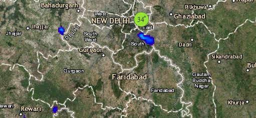
To begin with North India, the Western Disturbance lies over North Jammu and Kashmir. Its induced cyclonic circulation lies over North Rajasthan and adjoining Punjab. Therefore, light to moderate rains are likely over Jammu and Kashmir, Himachal Pradesh and Uttarakhand. Snowfall may occur over higher reaches of these states. Dust storm and thundershowers will occur in parts of Punjab, Haryana, Delhi, Rajasthan and West Uttar Pradesh.
Weather in most parts of Gujarat, Madhya Pradesh, Maharashtra and Chhattisgarh will remain dry and hot. In fact, isolated places in Gujarat, Marathwada and Vidarbha may even witness heat wave conditions. Thunderstorm in isolated pockets of Northwest Madhya Pradesh and North Chhattisgarh cannot be ruled out.
In East/Northeast India, a cyclonic circulation lies over foothills of Bihar and another cyclonic circulation is seen over Assam and Meghalaya. Thus, widespread rain and thundershower activities will continue over the northeastern states, Sikkim and Sub-Himalayan West Bengal. East India will remain dry mostly dry but thunderstorm in isolated areas of Bihar and Jharkhand is possible.
Click the image below to see the live lightning and thunderstorm across India
In South India, heat wave conditions may occur in parts of Telangana. A trough is extending across parts of Telangana, Andhra Pradesh, South Interior Karnataka and Tamil Nadu. Therefore, rain and thundershowers will continue Rayalaseema, South Karnataka, Kerala and Tamil Nadu. Rest of Andhra Pradesh and North Interior Karnataka will remain dry and hot.
Any information taken from here should be credited to skymetweather.com


