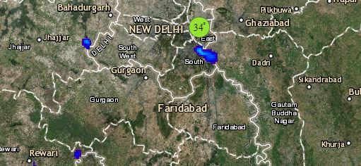
At present, the Western Disturbance is over Jammu and Kashmir and its induced Cyclonic Circulation now lies over Punjab and adjoining areas. Srinagar, Qazigund, Kullu, Manali, Shimla, Dharamshala might witness light to moderate rain and snow, whereas, Dehradun, Rishikesh, Haridwar, Nainital would witness intense rain and thundershowers. Good rains over Katra and Vaishno Devi also cannot be ruled out.
Rain and thundershower activities are also possible over Amritsar, Gurdaspur, Patiala, Chandigarh, Ambala, Bareilly, Moradabad, Saharanpur, Sri Ganganagar, Hanumangarh, Churu and Pilani. Delhi and adjoining areas like Gurugram, Faridabad, Ghaziabad, Noida might witness one or two short yet intense spells.
In Central India, a trough is seen running from southeast Uttar Pradesh to Gangetic West Bengal across Chhattisgarh and Jharkhand. Thus, light to moderate rain and thundershower activities with chances of hailstorm at one or two places of northeast Madhya Pradesh and North Chhattisgarh also seems to be a possibility. Weather of West Madhya Pradesh, Gujarat and most parts of Maharashtra would be dry and sunny.
Whereas in East and Northeast India, a Cyclonic Circulation is seen over Assam, which would only bring light rain at one or two places over Arunachal Pradesh and Assam. Further in east, Daltonganj, Ranchi, Jamshedpur, Bankura, Midnapore, Jharsuguda and Sambalpur might witness scattered rain and thundershower activities. Squally winds accompanied with lightning strikes are also possible over these areas.
Also, districts of southern Bihar like Gaya, Aurangabad might witness isolated rains.
Click the image below to see the live lightning and thunderstorm across India
Down South, an Anti-Cyclone is seen over central parts of Bay of Bengal, infusing moisture over Coastal Tamil Nadu and Andhra Pradesh. Some local development might give some isolated rains but chances are bleak. However, minimums are expected to rise by a couple of degrees. Weather over rest of southern peninsula will remain dry.
Any information taken from here should be credited to skymetweather.com


