Beginning with North, a fresh Western Disturbance is now over Jammu and Kashmir with its induced Cyclonic Circulation is over West Rajasthan and adjoining Pakistan. A trough is seen extending from this system up till southwest Uttar Pradesh. Another branch of trough is extending up till Maharashtra across East Rajasthan and Madhya Pradesh.
Thus, the new system would once again give rain and snow at many places of Jammu and Kashmir, Himachal Pradesh and few places of Uttarakhand. Places like Srinagar, Kashmir, Qazigund, Banihal, Kullu, Manali, Shimla, Rudraprayag, Keylong would be a witness to this.
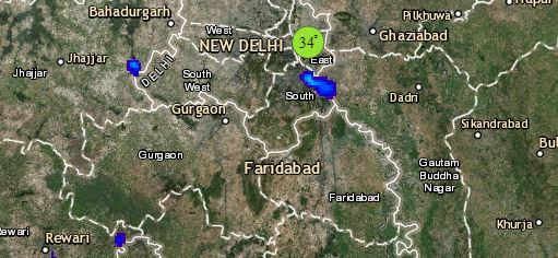
Also, rain and thundershower activities with hailstorm are expected over many places of Punjab, Haryana and West Uttar Pradesh, whereas scattered rains would be a sight over Rajasthan and Delhi. Chandigarh, Amritsar, Ludhiana, Ambala, Karnal, Hisar, Meerut, Bareilly, Saharanpur would witness few wet spells.
Scattered rain and thundershower activities are a possibility over Madhya Pradesh and Vidarbha. Places like Betul, Khandwa, Amravati, Akola, Nagpur and Gondia would witness rain. Whereas, isolated rains might be seen over Kutch region of Gujarat. Weather of Konkan and Goa, Madhya Maharashtra and Marathwada would be dry. Isolated hailstorm might be seen over South Madhya Pradesh and Vidarbha.
Click the image below to see the live lightning and thunderstorm across India
Weather of East and Northeast India would be dry. Minimums of Odisha and Gangetic West Bengal might increase marginally by 1°C-2°C. The day temperatures of northeastern states might rise due to clear sky and bright sunshine.
Down South, isolated light rains might occur over Coastal Andhra Pradesh and Interior Tamil Nadu. Weather of Bengaluru, Chennai and Hyderabad would be dry and warm.
Any information taken from here should be credited to skymetweather.com


