It has been ferociously raining and snowing in Jammu and Kashmir since last two days. All thanks to the Western Disturbance over Jammu and Kashmir, while its induced Cyclonic Circulation is over West Punjab and adjoining areas. A trough is also seen extending from this system up till Central Uttar Pradesh across Haryana and Delhi.
Thus, we expect more moderate rain and snow with few heavy to very heavy spells over Jammu and Kashmir, Himachal Pradesh and parts of Uttarakhand.
Fairly widespread rain and thundershower activities, light to moderate in nature with one or two heavy spells are also expected over Punjab, Haryana, Delhi, West and Central Uttar Pradesh. Not only this, scattered rains are also expected over West Rajasthan. These rains would also be accompanied with hailstorms.
Due to prevailing south-westerlies over Central India, the minimums of South Rajasthan, Gujarat, Madhya Pradesh and Maharashtra would remain above normal and may rise further. Isolated rain activities are possible over Northeast Madhya Pradesh and adjoining parts of North Chhattisgarh by the late night of January 22.
Click the image below to see the live lightning and thunderstorm across India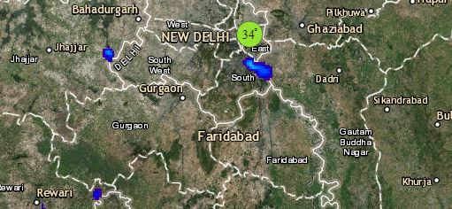
In East and Northeast India, a Cyclonic Circulation is seen over Meghalaya and its adjoining areas, leading to humid easterly winds over the northeastern states. With this, day and night temperatures might rise marginally, while weather of rest East India would be dry.
Down South, sky conditions over Tamil Nadu and Kerala might be partly cloudy to cloudy with medium to high clouds sans any weather activity. Weather over the states of Karnataka, Telangana and Andhra Pradesh would be dry whereas, isolated rains might occur over Andaman and Nicobar Islands.
Any information taken from here should be credited to skymetweather.com


