A Western Disturbance is over Jammu and Kashmir. Another Western Disturbance is over North Afghanistan. Its induced Cyclonic Circulation is over East Central Pakistan. We expect, scattered rain and snow in Jammu and Kashmir, Ladakh and parts of Himachal Pradesh. Isolated rain is likely in Uttarakhand. On the other hand, the weather of northern plains will remain dry. However, minimums may increase by a couple of degrees in Punjab, Haryana, Delhi and West Uttar Pradesh. Delhi pollution will be in poor to very poor category. Isolated pockets may even come under severe category due to decreased wind speed.
In East and Northeast India, a Cyclonic Circulation is over Sub Himalayan West Bengal. Humid winds from the Bay of Bengal are increasing moisture in Northeast India. Therefore, rain and snow may occur in Arunachal Pradesh and in one or two parts of Sikkim. Scattered showers are likely in Assam, parts of Nagaland and Meghalaya. However, the weather of East Uttar Pradesh ,Bihar, Jharkhand , Odisha and West Bengal may remain dry. Kolkata will be warm and humid.
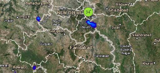
Click the image below to see the live lightning and thunderstorm across India
Dry weather conditions may continue in entire Central India. Day will be sunny and very warm in Gujarat, Rajasthan, Madhya Pradesh and Chhattisgarh. The temperatures of Mumbai and Konkan and Goa will drop by 2-3 degrees Celsius.
Talking about South India, an Anti-Cyclone is over the Arabian Sea, therefore, we expect the day temperatures of Kerala and Karnataka to remain hot in the range of 36 to 38 degrees. However, humid winds from the Arabian Sea will keep the day temperature of Coastal Andhra Pradesh and Coastal Tamil Nadu in the lower 30s. We do not expect any weather activity in Chennai, Bengaluru and Hyderabad.
Any information taken from here should be credited to skymetweather.com


