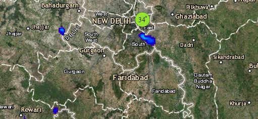
To begin with North India, the Western Disturbance is over Jammu and Kashmir and it’s induced cyclonic circulation is now over North Rajasthan and adjoining Punjab and Haryana. The systems will continue to give rain and snow at many places over Jammu and Kashmir, Himachal Pradesh and a few places of Uttarakhand. Scattered rains can be witnessed over Rajasthan, Punjab and Haryana.
Delhi may receive light to very light rain at one or two places and they won’t be of any help in subsiding pollution. Western parts of Uttar Pradesh will continue to witness dry weather and minimums are expected to rise marginally over northwest plains.
Moving to Central India, a trough is extending from Jharkhand up till Karnataka across Odisha, South Chhattisgarh and Telangana. Thus, rains can be seen over few places over Chhattisgarh, East Madhya Pradesh and one or two places of Vidarbha. Rest regions of Gujarat, Maharashtra and Madhya Pradesh will remain dry.
Click the image below to see the live lightning and thunderstorm across India
In South India, the low-pressure area persisting over southcentral Bay of Bengal will gradually intensify into a well-marked low-pressure area by December 13. This can give good rains over Andaman and Nicobar Islands. Kerala may receive isolated light rains and scattered rains can be seen over Telangana. Weather of Karnataka, Andhra Pradesh and Tamil Nadu will remain dry.
Lastly in east/northeast India, because of the trough isolated light rains are possible over Jharkhand. Odisha may receive rain over few places. Weather of East Uttar Pradesh, Bihar and West Bengal will remain dry. Arunachal Pradesh along with Northeast Assam may receive light rain at one or two places. Rest will remain dry.
Any information taken from here should be credited to skymetweather.com


