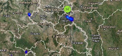
The Western Disturbance now lies over East Jammu and Kashmir. Its induced cyclonic circulation is seen over Punjab and adjoining areas. And a trough is extending from this system up to Southeast Uttar Pradesh across Haryana. Therefore, light to moderate rain and thundershowers will continue over the hills of North India. Uttarakhand may receive one or two heavy spells of rain. Punjab, Haryana and West Uttar Pradesh will also witness good rain and thundershowers with isolated dust storm and hailstorm activities. One or two spells of rain are also expected in Delhi-NCR and East Rajasthan.
Weather of Gujarat and West Madhya Pradesh will become dry. Whereas, scattered rain and thundershowers will continue over East Madhya Pradesh, Chhattisgarh and Vidarbha. Day temperatures will rise over South Rajasthan, Gujarat and West Madhya Pradesh.
In East/Northeast India, East Uttar Pradesh, Bihar and Jharkhand will receive scattered rain and thundershowers. Isolated rains are possible over Gangetic West Bengal and Odisha. Due to the cyclonic circulation over Assam, good rains will continue over Sub-Himalayan West Bengal, Sikkim, Assam, Meghalaya and Nagaland.
Click the image below to see the live lightning and thunderstorm across India
Lastly in South India, due to the trough running across Telangana and Interior Karnataka, we expect isolated rains over Telangana, Coastal Andhra Pradesh, Karnataka and Kerala. Tamil Nadu will remain almost dry.
Any information taken from here should be credited to skymetweather.com


