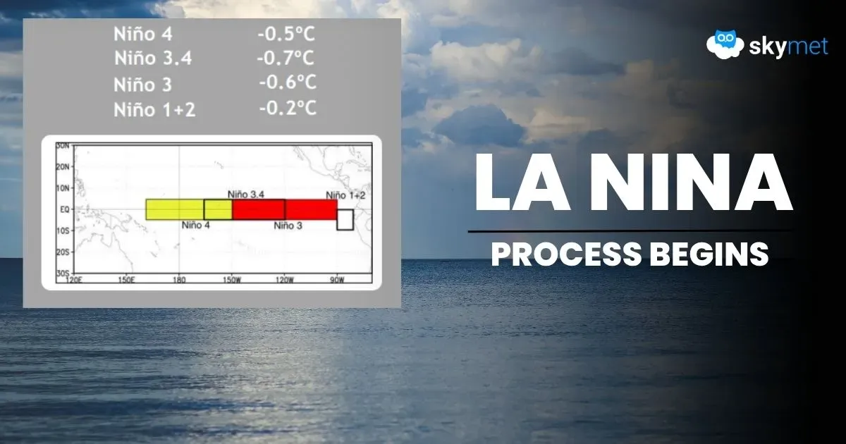
ONI Reach Threshold Mark: La Nina Process Begins

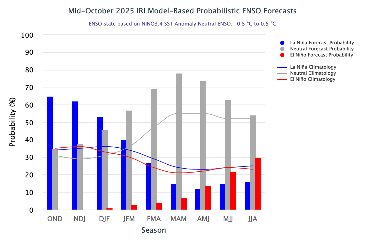
Latest data shared by the World Meteorological Organization (WMO) indicate a 55% likelihood that sea surface temperatures in the equatorial Pacific will cool to La Niña levels from September to November 2025. For October to December, the probability of La Niña conditions slightly increases to about 60%. There is little chance of El Niño developing during September to December.
About 90% of the excess heat from global warming is stored in the ocean, making ocean heat content a critical indicator of climatology, WMO said in an update. Though the cooling climate phenomenon La Niña could return by November, it will not halt the trend of warmer global temperatures caused by human activity. While La Niña and El Niño strongly influence climate by altering ocean surface temperatures and driving changes in winds, pressure, and rainfall patterns, human-induced climate change is still increasing global temperatures, intensifying extreme weather, and impacting seasonal rainfall and temperature patterns, WMO noted. The year 2024 has been adjudged the hottest so far, with the global average surface temperature 1.55°C above the 1850–1900 average.
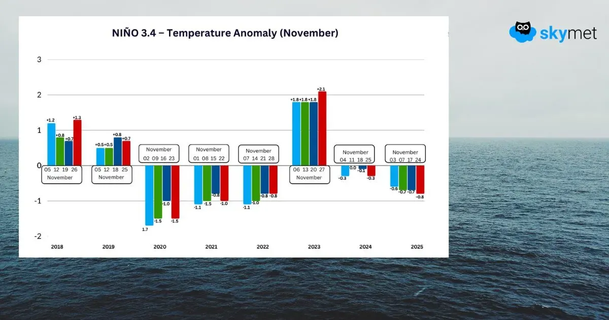
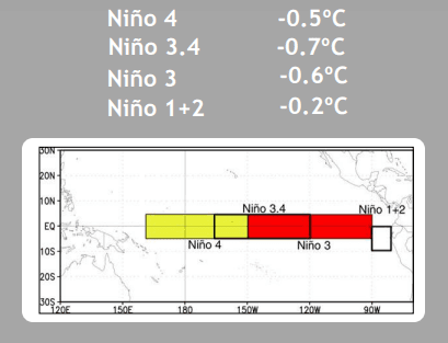
ENSO: Sea surface temperature anomalies in the central equatorial Pacific reflect a clear cooling trend, indicating that cold conditions are gradually developing in the Niño region. The IRI’s definition of La Niña, similar to NOAA/Climate Prediction Center’s, requires that the monthly SST anomaly in the Niño 3.4 region (5°S–5°N; 170°W–120°W) exceed –0.5°C, meaning the anomaly must be colder than –0.5°C. Borderline negative anomalies have prevailed for the last four weeks. There is no sharp drop over the sea surface or the subsurface. Overall, current conditions continue to reflect an ENSO-neutral state, and La Niña advisory remains in vogue.
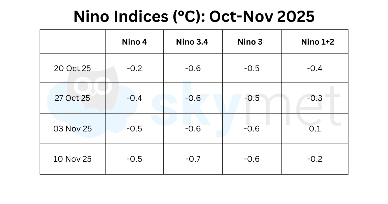
The Niño 3.4 index, the marker for ONI, has lowered further. The latest weekly value as on 10 Nov 2025 was –0.7°C, the lowest so far since January 2025. As estimated earlier, the ONI for the season Aug–Sep–Oct has reached the threshold mark of –0.5°C. It may be construed that the La Niña process has just begun, yet there is a long way to go for the event to fully establish.
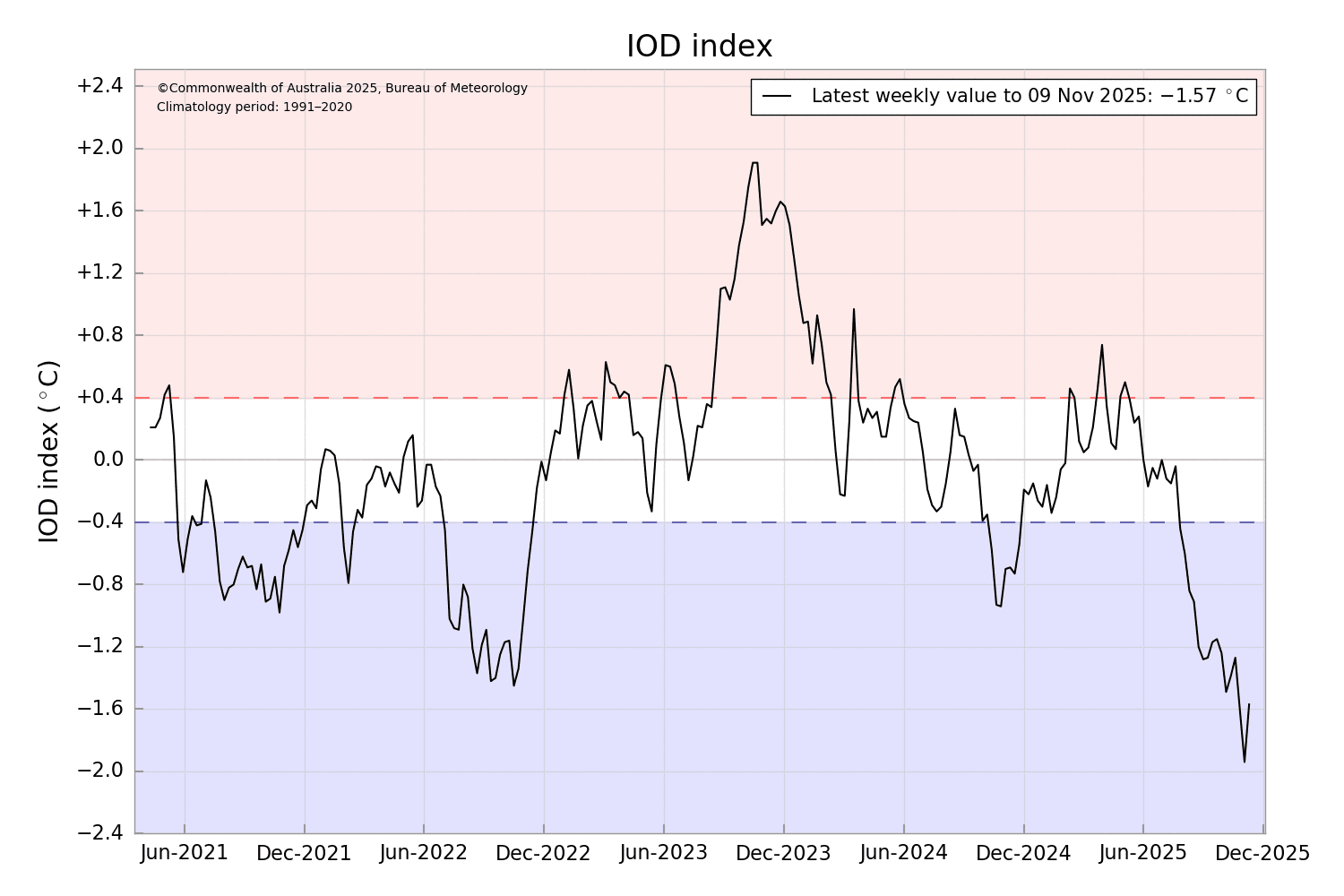
IOD: Sea surface temperature analysis for the week ending 09 Nov 2025 shows warmer-than-average waters across most of the Australian region. The intensity of the Dipole Mode Index (DMI) is represented by the anomalous SST gradient between the western equatorial Indian Ocean (50°–70°E / 10°S–10°N) and the southeastern equatorial Indian Ocean (90°–110°E / 10°S–10°N). IOD is a coupled ocean-atmosphere phenomenon and can also be represented using pressure, outgoing longwave radiation (OLR), or even sea-surface height. The negative Indian Ocean Dipole event remains active. The latest index value for the week ending 09 Nov 2025 was –1.57°C. The Bureau’s models predict that the negative IOD will weaken during November and return to neutral in December, consistent with most international models and with the typical IOD life cycle.
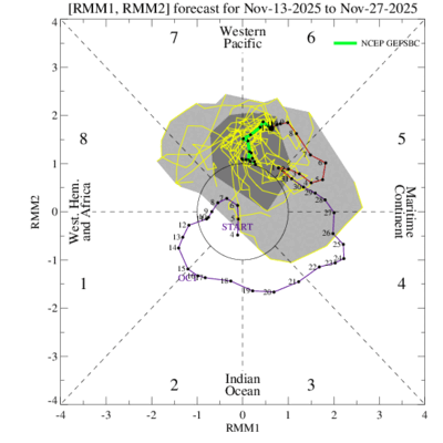
MJO: The Madden–Julian Oscillation is currently over the Western Pacific in Phase 6. It is likely to meander over that region for the next two weeks. Earlier, the signal showed signs of weakening with some westward retrogression under the influence of emerging La Niña in the Pacific. However, the pulse has resumed its normal eastward propagation and may remain over the West Pacific for the rest of November. It is expected to stay active during this period. The peak of the West Pacific typhoon season is from August to October, though activity can be strong from June to November. Recently, two super typhoons, Kalmaegi and Fung-Wong, tracked over warm Pacific waters, ravaging the Philippines and Taiwan. Another tropical storm is likely in the Western Pacific during the last week of November. The Bay of Bengal also appears favourable for convective activity, with potential formation of an active weather system anytime after 20 Nov 2025.
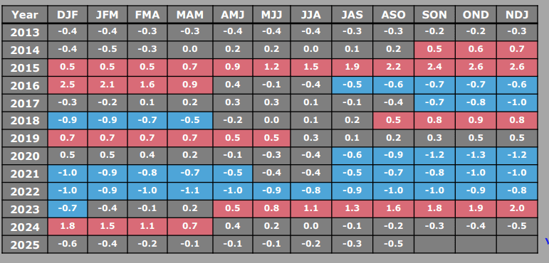
The temperature anomaly in the Niño 3.4 region has consistently breached the threshold mark of –0.5°C for the last four weeks. The moderate fall in sea-surface temperatures during this period has initiated the onset of La Niña. The SST anomaly is likely to remain between –0.5°C and –1°C until mid-December 2025.
Skymet is India’s most accurate private weather forecasting and climate intelligence company, providing reliable weather data, monsoon updates, and agri-risk management solutions across the country.