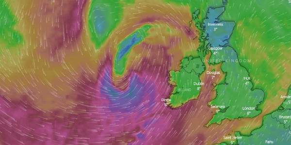
Storm Erik is all set to batter Ireland, Scotland and adjoining areas with rains and ferocious winds gusting up to about a 100 kmph. A yellow warning has been issued on Friday as well as some part of Saturday. Moreover, there is likely to be traffic chaos resulting in road, rail, ferry, air delay to quite an extent.
Not only this, there is a possibility of large waves in coastal areas, power cuts, fallen trees, along with a risk of flying debris. The Irish weather service, which has also named the storm, has issued an orange warning for Galway, Mayo and Donegal counties.
Storm Erik will be reaching Ireland soon bringing damaging winds to the country along with many other parts of the United Kingdom. The system is expected to rapidly deepen as it reaches close to Northwest Scotland and Ireland.
This is called rapid cyclogenesis, an explosive cyclogenesis or even a weather bomb at times as the centre of the low drops at a fast pace over a very short time, causing the storm to intensify at a very rapid speed. Rainfall activity is expected to remain heavy for the rest of the day and may spill over tomorrow as well. In fact, residents have been warned of remaining cautious as wind speed may be as fierce as possible.
Image Credit: windyty


